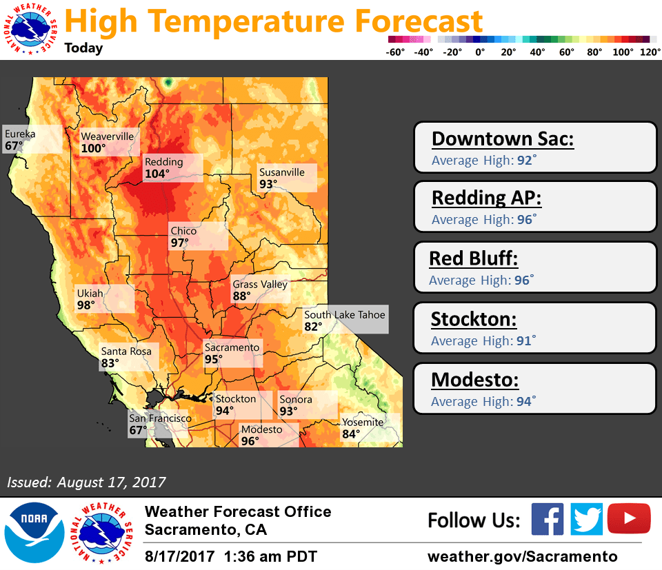
August 17, 2017 – Temperatures near to slightly above normal with a threat of late-day mountain thunderstorms.
Discussion (Today through Saturday)
Strong Delta breeze early this morning with marine layer about 2000 ft deep per Ft. Ord profiler. Fog product imagery showing coastal stratus extending inland to near Cordelia attm. Patchy stratus may pop up around the Sacramento area around sunrise but will be short lived.
Some warming expected today over Interior NorCal as high pressure in the EPAC builds inland. Max temps this afternoon forecast to be around 3 to 7 degrees above normal. Elevated instability progs point to the potential for deep moist convection over the higher terrain of the Sierra Nevada, mainly south of Highway 50, this afternoon.
Slight warming continues over Interior NorCal Friday under increased subsidence, shallower marine layer, and weaker Delta breeze. Higher levels of 700-500 MB MU CAPE and TT values exceeding 30 progged over the higher terrain of the Sierra Nevada again tomorrow, but also over the Coastal range for a threat of afternoon to early evening thunderstorms there as well.
Heights/thicknesses trend down over Interior NorCal through the weekend as upper troughing deepens over the area. As a result, onshore flow increases along with depth of marine layer. High temperatures trend down to near normal by Sunday. Afternoon thunderstorms again possible over the higher terrain of the Sierra Nevada Saturday, expanding to increase the NE and N mountains Sunday.
Extended discussion (Monday through Thursday)
An upper level low will be setting up off the coast of SoCal to start the extended period. This will push moisture north into NorCal and bring a chance for Mountain t-storms during the afternoon and evening both Sunday and Monday. Of course Monday is a day you will want minimal cloud cover to see the eclipse. It does look like there will be enough moisture to see some clouds in the valley but not expecting widespread cloud cover.
Not as much moisture is expected on Tuesday and that should limit the thunderstorm chances but still could see some activity mainly over the coastal range of Tehama and Shasta Counties.
On Wednesday the upper level low pushes east as a trough drops south out of the Gulf of Alaska. This will bring troughing for the end of the period but mountain thunderstorm chances look limited. Overall temperatures will be seasonal throughout the period to maybe a few degrees below normal on Tuesday.