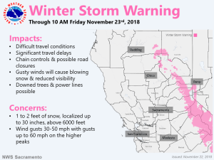
November 22, 2018 – Active weather pattern continues for next few days with wind, rain, and snow. Risk for ash/debris flows will continue in newly burned areas. Snow over the higher elevations of the Sierra will make travel difficult for the Thanksgiving travel period.
Discussion
Short-wave trough moving through early this morning with showers and a few thunderstorms across interior NorCal at this time. Currently, the heaviest concentration of showers is across Butte County and between Sacramento and Stockton. 1 hour rainfall amounts of around 1/4 to 1/3 of an inch have been observed so far as these heavier showers have passed. Snow continues across the higher elevations of the northern Sierra.
Brief lull expected across much of the area after sunrise until later this afternoon when wind and precipitation will begin to increase as the next wave of the storm moves in. With a wide swath of available deep moisture (TPW of 1 to 1.25 inches), a nearly stationary frontal zone overhead, and orographically favorable southwest flow of 35-50 kts at 700 mbs, periods of heavy precipitation are likely across the foothills and west slopes of the northern Sierra Nevada/southern Cascade Range.
The Central Valley will be shadowed somewhat, though most areas will see rainfall in excess of a third of an inch. Enhanced convergence at the north end of the Sacramento Valley, and across the Sacramento region may lead to an inch or more for those areas.
Only minor adjustments to QPF, snow amount and wind have been made.
Upper ridging expected to bring a return of quieter weather over the weekend.
Extended Discussion (Monday through Thursday)
Dry conditions and seasonal temperatures expected on Monday. A return of precipitation is likely during the second half of next as a strong moist westerly flow develops. However, model uncertainty remains evident in terms of precipitation amounts, and timing, with the 00z GFS run showing a slower progression compared to the 00z ECMWF run. Despite model differences, widespread precipitation, locally gusty winds, and cooler temperatures could be possible as several systems move across the region. At this point, the first system is anticipated to move across interior NorCal Tuesday into Wednesday. This system could be followed by a potentially wetter system around Thursday, but confidence remains low. A gradual cooling trend is expected during the extended period, with Valley highs in the 50s, and 40s to 50s over the mountains.

