February 1, 2021 – A winter storm will move across NorCal late Monday into Wednesday with mountain travel impacts. Dry weather should return by Thursday and continue through the weekend with periods of increased north to east winds.
Discussion
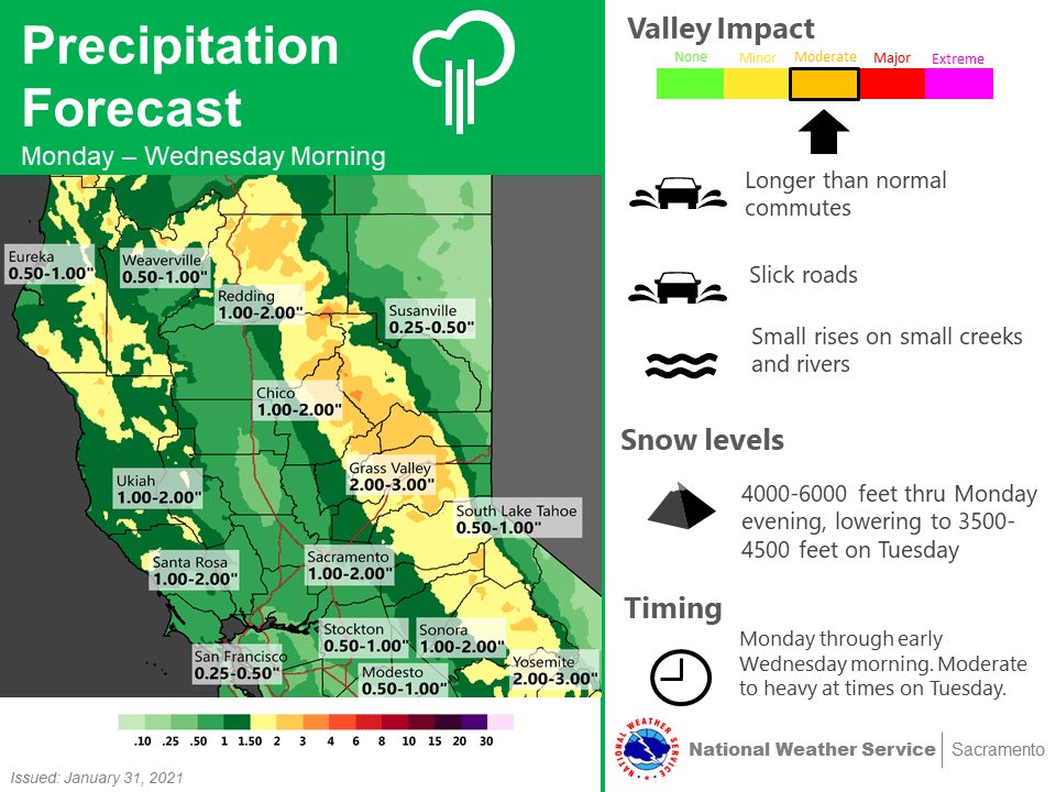
GEFS ensemble shows trough to approach the west coast Monday and swing through northern California Tuesday and Tuesday night. Main moisture plume ahead of the trough will impact the area Monday night and Tuesday. Then transition to more of a showery pattern Wednesday and Wednesday night on the back side of the trough. The trend has been slower and with less precip with each forecast run. Still, a moderate precip event looks likely, especially over higher elevations.

Have upgraded winter storm watch to a warning Monday night into early Wednesday, as WPC winter storm index is indicating a brief period of moderate winter storm impacts at pass level Tuesday morning into the afternoon. Currently expecting 10 to 18 inches with locally 2 feet of snow for storm totals above 5000 feet. Snow levels will start off near 6000 feet Monday night and fall to 4000 feet Tuesday afternoon. Sref ensembles are indicating storm total 4 to 8 inches at Blue Canyon(5280 feet).
Atmosphere will also turn a bit convective Tuesday afternoon, as indicated by 200-300j/kg of cape over the Sacramento Valley, slight thunderstorm chances look possible Redding to Sacramento. Valley Rainfall amounts are expected to range from 0.50 to 1.00 inches with 1 to 2 inches over the foothills.
Winds don’t appear to be a major impact with this system, but could see a few south gusts to 30 mph over the northern Sacramento Valley late this afternoon and again Wednesday.
Ensembles and clusters are in agreement with trough shifting east into plains Thursday with eastern Pacific high building east into California. This will bring a drying and warming trend.
Extended discussion (Friday through Monday)
Strong upper high off the West Coast will result in dry weather through the extended forecast period with above normal daytime temperatures. Locally breezy north to east wind possible at times becoming stronger and more widespread early next week.