Archive of the Mosquito Fire from September 6, 2022 through September 18, 2022.
September 18, 2022 at 7:08 PM
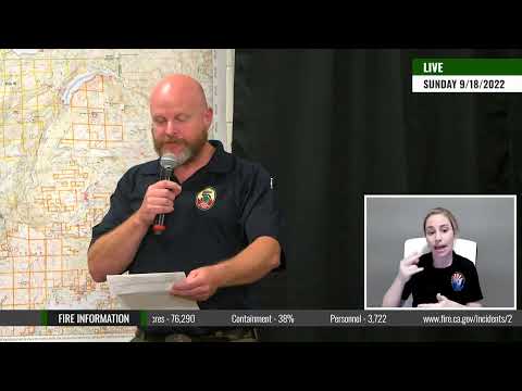
Fire Behavior Analyst Jonathan Pangburn reports: “Well, as you can see outside, it’s been raining a little bit today and you heard from our meteorologist, we can expect quite a bit more of that in the near future. However, I do want to remind you that we just heard from our operations section chief Dave that they were able to do some firefighting out here, including some firing operations. And so I just wanted to remind our folks out there, when it’s raining and you’re still able to do a firing operation, it just goes to show how critically dry the fuels have been in this area. We experienced record breaking heat and we had record breaking dry fuels. So that is the challenge facing our firefighters. The rain of course, is going to keep the fire relatively in place. Where it is, we’re not expecting any rapid growth, in fact, we’re not expecting any real growth of the perimeter at all right now. However, our firefighters still have a challenging job in some very rough terrain to make sure that we get really extensive mop up and extinguish those heats so that when that temperature does rise and the heat air starts to dry, as you heard from Eric, that is going to occur starting in this weekend that we have a safe area that is not going to extend any further.”
September 18, 2022 at 6:58 PM
The evening briefing will start at 7:00 pm.
September 18, 2022 at 6:57 PM
With the significant increase in containment and tireless work by firefighters and cooperators to ensure that communities would be safe for repopulation, a large number of Mosquito Fire evacuees were allowed back home today. Both the Placer and El Dorado County Sheriff Offices downgraded many of the Evacuation Orders and Warnings in their perspective counties this afternoon.
Rain showers covered most of the fire area throughout the day. The cooler temperatures, higher humidity, and wet conditions subdued fire activity around the fire. Firefighters took advantage of these slower fire conditions to construct direct control lines along portions of the fire’s edge on the eastern flank. Firefighters with hand tools and heavy equipment, such as dozers, were out in force constructing these control lines. Crews worked in the area of the North Fork of the Middle Fork of the American River as well as the Interbay Road. Despite the rain showers, crews were able to successfully conduct firing operations along the Interbay Road and connecting control lines due to the sustained dry fuel moisture in the vegetation. Firefighters were able to continue strengthening and holding control lines around the southeast corner near Stumpy Meadows.
A majority of the aircraft assigned to the incident was able to be used throughout the day. Aircraft primarily focused on assisting the ground crews on the eastern flank of the fire. Helicopters were actively engaged in both water and retardant dropping missions. These air operations are a great resource for ground crews to knock down hot spots and reinforce control lines with retardant to the stop the fire’s progression.
Heavier rains and continued southwest winds are forecasted overnight and into Monday. A possibility of scattered thunderstorms may occur Tuesday. Firefighters will continue direct and indirect line construction along the eastern flank of the fire. Crews will patrol and mop up all existing containment lines along the southern and western flanks to ensure there are no threats to life and property in those communities.
September 18, 2022 at 6:11 PM
Minimal fire behavior with precipitation occurring over the fire.
Approximately 40 PG&E customers remain without power.
Both Placer County and El Dorado County Sheriffs reduced Evacuation Orders in several areas from Mandatory to Warning. 8,290 people remain evacuated.
Containment has reduced risk, but a threat remains for: Foresthill, Baker Ranch, Todd Valley, Georgetown, Stumpy Meadows, Michigan Bluff, Chickenhawk Ridge, Volcanoville, Quintet, and Todd Valley.
September 18, 2022 at 2:33 PM
Order to Warning: Cannon Creek
This is the El Dorado County Sheriff’s Office of Emergency Services with an important message for your community. The following areas will be placed back into an evacuation warning, allowing you to return to your property:
This includes the area north of the intersection of Spanish Dry Diggins Road and Sliger Mine Road and North of the intersection of Spanish Dry Diggins and Reservoir Road.
Be aware this is still an active fire and your area could return to an evacuation order if the fire and conditions change. Please drive safely as there are emergency responders and utility workers still working in your area.
Order to Warning: Bottle Hill
This is the El Dorado County Sheriff’s Office of Emergency Services with an important message for your community. The following areas will be placed back into an evacuation warning, allowing you to return to your property:
This includes the community north of the intersection of Wentworth Springs Road and Breedlove Road and South of Bottle Hill Road.
Be aware this is still an active fire and your area could return to an evacuation order if the fire and conditions change. Please drive safely as there are emergency responders and utility workers still working in your area.
Order to Warning: Grey Eagle
This is the El Dorado County Sheriff’s Office of Emergency Services with an important message for your community. The following areas will be placed back into an evacuation warning, allowing you to return to your property:
This includes the area west of Kings Meadow, East of the intersection of Wentworth Springs Road and Breedlove, South of Wentworth Springs and North of Bald Mountain Canyon.
The area North of Wentworth Springs will remain in an evacuation order.
Be aware this is still an active fire and your area could return to an evacuation order if the fire and conditions change. Please drive safely as there are emergency responders and utility workers still working in your area.
Voluntary Lifted- Cool
This is the El Dorado County Sheriff’s Office with an important message. The evacuation warnings for the Mosquito Fire have been lifted for all homes in the Cool area.
This includes the area East of Highway 49, South of the County Line, North of Highway 49/Coloma Road, and West of Greenwood Road.
Emergency personnel could still be working in the area, so please drive safely.
Voluntary Lifted- Garden Valley
This is the El Dorado County Sheriff’s Office with an important message. The evacuation warnings for the Mosquito Fire have been lifted for all homes in the Garden Valley area.
This includes the area East of Lichen Creek, South of Greenwood Road, North of Highway 49, and West of Rock Creek Road.
The National Forest is still closed by Forest Order. Emergency personnel could still be working in the area, so please drive safely.
Voluntary Lifted- Georgetown Proper
This is the El Dorado County Sheriff’s Office with an important message. The evacuation warnings for the Mosquito Fire have been lifted for all homes in the Georgetown Proper area.
This includes the area West of the intersection of Breedlove Road and Wentworth Springs Road, East of Greenwood, South of the Bottle Hill Road, and North of Meadow Brooke Road.
The National Forest is still closed by Forest Order. Emergency personnel could still be working in the area, so please drive safely.
Voluntary Lifted- Swansboro
This is the El Dorado County Sheriff’s Office with an important message. The evacuation warnings for the Mosquito Fire have been lifted for all homes in the Swansboro area.
This includes the area East of Garden Valley, South of Sand Mountain, North of the Mosquito Bridge and West of Traverse Creek.
The National Forest is still closed by Forest Order. Emergency personnel could still be working in the area, so please drive safely.
September 18, 2022 at 1:48 PM
Flash Flood Watch for the Mosquito burn scar in effect from Tuesday afternoon through Tuesday evening.
WHAT: Ash and debris flows caused by thunderstorms are possible over the Mosquito burn scar.
WHERE: A portion of northern California, including the following areas, Motherlode and West Slope Northern Sierra Nevada.
WHEN: From Tuesday afternoon through Tuesday evening.
IMPACTS: Thunderstorm threat with possible heavy rainfall over the Mosquito burn scar is expected during the period of the watch. Residents near the Mosquito burn scar should prepare for potential ash and debris flow impacts. Be sure to stay up to date with information from local authorities. Areas with steep terrain will be especially at a higher risk for ash and debris flows.
September 18, 2022 at 1:00 PM
Per Placer County Sheriff: We continue to monitor and evaluate repopulation for affected residents of the Mosquito Fire, and are now lifting the evacuation order for zones 8, 9, 10, and 11A to an evacuation warning. Repopulation of these areas may now occur.
Zone 7 has been split into 7A and 7B. 7A includes Patent Road, and 7B includes Todd Valley: East of McKeon-Ponderosa, west of Jarvis Rd, south of Foresthill Rd, north of the canyon rim of the Middle Fork of the American River. Zone 7A remains under an evacuation order and zone 7B has been lifted to an evacuation warning. Repopulation of the 7B area may now occur.
Zones 15, 12, and 26 have been lifted from an evacuation warning and are now open. Repopulation of these areas may now occur.
As a result of today’s repopulation effort, 3,701 residents will be able to return to 1,608 structures. As residents return home, we ask they remain aware of their surroundings as public safety personnel continue to work in the area. Areas still under an evacuation order will continue to be patrolled and monitored by deputies and other law enforcement. We will continue to keep the community updated with new information and thank everyone for their patience and understanding as we monitor the current conditions to determine when it is safest for residents to return home. You can access important information about returning home after a fire here: https://www.placer.ca.gov/8266/Returning-Home
Traffic control points:
- Foresthill Rd is closed just east of Todd Valley Rd
- Yankee Jims Rd is closed at Adam Pit Rd
- Elliott Ranch Rd/Giant Gap Rd is closed at Iowa Hill Rd
- Finning Mill Rd and Sugar Pine Rd are closed at Iowa Hill Rd
- Patent Rd is closed at Todd Valley Rd/Jarvis Rd
- Soda Springs Rd is closed at the North Fork of the American River
- McKinney Rubicon Springs
September 18, 2022 at 11:14 AM
The Placer County Animal Services Center and Gold Country Fairgrounds will be open today until 8 p.m. for residents to pick up their animals that have been sheltered due to the Mosquito Fire. Please contact Animal Services at 530-886-5541 if you need additional information.
September 18, 2022 at 9:57 AM
TNF Air Attack 17 is over the fire for a recon flight.
September 18, 2022 at 8:28 AM
NWS Sacramento Incident Meteorologist (IMET) Eric Kurth provides a weather update for Sunday September 18th on the Mosquito Fire.

September 18, 2022 at 8:26 AM
Operations Section Chief Donald Fregulia gives us our daily Operational Update for Sunday, September 18th, 2022 on the Mosquito Fire.

September 18, 2022 at 7:50 AM
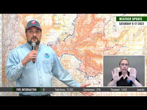
Colder temperatures, good humidity recovery, and precipitation arrived overnight with the forecasted storm system. Rain showers are expected to continue throughout the day and become heavier this evening and into Monday. Southwest winds are predicted to become stronger midday with 24-28 mph gusts over the ridges. Higher humidity and temperatures in the 50s are expected for the fire area today.
Firefighters worked throughout the night to patrol, hold, and improve existing containment lines around the fire’s perimeter, especially along the impacted communities on the south and western flanks. On the north end of the fire, crews continued to monitor and hold the control lines on Deadwood Road as there had been increased pockets of heat below those lines on Friday. Firefighters continued suppressing fire activity and secured the slop over along the eastern front between the Middle Fork of the American River and French Meadows Road. Crews successfully continued firing operations overnight along the Interbay Road until precipitation arrived early this morning. These operations continue to aid firefighters in stopping the fire’s spread eastward. Day shift firefighters will work to tie in control lines coming down from the Eleven Pines Road through Devil’s Peak to the rim of the Rubicon River. Control lines consisting of dozer and hand lines connect the dots around the southeast corner back to Stumpy Meadows and Wentworth Springs Road.
As rain showers are forecasted to continue through the day and become heavier overnight, crews will look for opportunities to make containment progress as it is safe to do so. Firefighters will continue shoring up the corners of the fire and ensure the southern and western flanks hold along the communities.
Firefighters will also continue the process of backhauling unneeded hose, tools, and equipment from areas where they are no longer needed. Each day, operations section chiefs, law enforcement officials, and cooperators continue reevaluating the evacuation status of communities as they work towards safely repopulating these areas.
September 18, 2022 at 7:03 AM
Fire behavior Saturday night was minimal, consisting primarily of creeping and smoldering. Light precipitation occurred across the fire area Saturday night.
Saturday evening, southwest winds ahead of the approaching storm system were gusty over ridges. After 7 PM, winds diminished shifted to the southeast on ridges and light downcanyon. An inversion developed around midnight, blanketing the fire with heavy smoke. Temperatures dropped to 40–50 degrees with relative humidity rising to 75–90%. Light rain showers passed through in the early morning hours Sunday.
As the storm system moves inland Sunday, southwest winds will increase in the afternoon and early evening, gusting up to 28 mph over ridges. Temperatures will trend cooler and humidity higher. Wetting rain expected late afternoon Saturday, continuing into Monday. Tuesday could also see isolated thunderstorms, with lingering showers through Wednesday. More than an inch of rain is expected. Drier and warmer weather returns Thursday.

September 17, 2022 at 9:36 PM
As anticipated, increased southwest winds arrived today ahead of the approaching storm system with gusts of 20-25 mph along the ridgelines. Increased cloud cover and cooler afternoon temperatures moderated some of the fire activity today. Portions along the eastern flank of the Mosquito Fire remained active this afternoon as the fire continues burning in areas with dry fuels. A spot fire occurred just outside the fire’s main eastern edge in the area of French Meadows Road and crews are actively working to contain it. This spot fire is still within contingency lines that have been constructed on the eastern side of the fire. Firefighters continue to make good progress holding the fire along the Eleven Pines Road and other control lines along the eastern flank moving south towards the Rubicon River drainage. Crews were able to successfully engage in strategic firing operations to continue building a buffer along these control lines. Firefighters have been continuing to patrol the southern and western flanks of the fire to aggressively mop up any remaining hot spots anywhere near control lines. These crews are ensuring that the burned areas along containment lines are completely extinguished with no threat of escape.
Tonight, firefighters will patrol, mop up, and secure all established control and containment lines in an effort to ensure the fire remains within these existing lines while being tested by this wind event. Crews continue to monitor and hold portions of active fire along Deadwood Road and the eastern flank. Night flying helicopters will assist ground crews tonight with reconnaissance and water-dropping missions. Winds are forecasted to diminish overnight, with precipitation starting tomorrow and becoming heavier into Sunday night. The wetting rain is predicted to continue through Wednesday with totals forecasted to be close to 1” by the storm’s end. Firefighters are looking at this wet weather as a speed bump for the fire growth, where they can take advantage of the decreased fire activity and make good progress in increasing containment.
September 17, 2022 at 7:08 PM
Placer County Sheriff announces repopulation of Zone 12: Foresthill Rd from Foresthill Bridge to Drivers Flat, Old Foresthill Rd/Old Auburn Foresthill Rd from Hwy 49 to Foresthill Rd, all roads off of Foresthill Rd within this stretch.
Fire behavior Saturday was moderate, consisting primarily of creeping, uphill runs, and isolated torching. Better ventilation cleared the thick smoke layer today. Fire areas exposed to the wind saw an increase in fire behavior. Fuel moistures lowered quickly in response to the air movement and sun exposure. Moderate humidity and cooler temperatures did not impede fuels from burning well in terrain with alignment to the wind. The fire made uphill runs in the North Fork of the Middle Fork of the American river. Isolated torching occurred in a few locations on the eastern portion of the fire. Surface vegetation experienced creeping fire.
Fire activity is expected to be minimal overnight Saturday. However, windy conditions will continue through the night and will keep vegetation ready to burn until the arrival of possible showers early Sunday morning.
September 17, 2022 at 7:08 PM
Current situation on the fire here today. Starting down in the Middle Fort and coming up towards Todd Valley before his Hill area. It was real smoky in the morning. Got crews down in there, started mopping up along the fires edge and working in and I was asked to explain what mopping up is and just the short answer would be that’s like we asked you to do with your campfires, get in there, drown it, stir it, feel it, make sure that it’s cold and it’s out. And so they’re doing that for miles up out of this area down here and they’re doing it about 100ft in right now and working on getting even further than that. That mop up continued all the way up towards the Forest Hill Road and then out all the way through Forest Hill, out towards Michigan Bluff and out to the Deadwood Road and driving that road looks really good. There’s not a lot of smoke showing and when that smoke started blowing out with the winds this afternoon you weren’t even seen any new smokes down here low. So looking really good all the way across here coming up into the northern end of the fire. We keep working on our plan and our indirect fire line out to the east and bringing it down to the south. Did have a pocket of heat. Start putting up a lot of smoke in the afternoon around two or three in the afternoon. Didn’t move much, didn’t burn out much. Just looked impressive from a distance. At the same time as we were working on these outside lines we had folks in close to the fire working with dozers and with hand crews trying to get that thing down into the middle fork of the river and then on the south side of the middle fork of the river. I’m really glad to say today, even with those winds and even with the fire behavior, a bunch of crews were able to get down in there and start coming up from the river to the south. Gotten a really good firefight down in there holding the line where they couldn’t use dozers. They just pulled out the hand tools and the chainsaws and they just started working their way to the east along the fire’s edge for a few miles until they could tie that into French Meadows Road and then continue coming south and tie that in with those hand tools and going direct all the way over to eleven piles down in this area and then that road that they’ve been in a firefight the last couple of days holding onto it. They kept holding on to that and they were able to turn a corner off of that and start coming south. There’s a little pocket where they couldn’t get in close to the fire. But as soon as they could they took that opportunity. Come back out to that fire’s edge and keep working that with their hand tools. With their chainsaws. With dozers whatever tools they could use to get in there and corral this fire all the way down to the rim of the Rubicon River where they just couldn’t get in any further safely. Didn’t want to get anybody hurt. Just an amazing piece of firefighter all through this southeast corner of the fire today and we’ll see as they mop that up and as the wind continues to press, that how things go. But right now looking really good in there. Once you come across the Rubicon and you come down in that Stumpy Meadows area that’s kind of been like it has been for the last several days, they’re mopping up along the road systems and their line coming across into Quintet out to Volcano Bell. Things are really quiet, looking really good and that line hasn’t moved in several days now, so looking really confident in there and then when you start coming out Volcanoville towards Buckeye Point where did the firing operation five, six days ago now continuing to mop up and secure that edge and like I was saying was looking down in there this afternoon, it was looking really good. Thank you for listening.
September 17, 2022 at 6:54 PM
The evening briefing will start at 7:00 pm.

September 17, 2022 at 6:49 PM
Helicopters are moving off the fire, shutdown time is approaching.
September 17, 2022 at 6:01 PM
73,381 acres, mapped by FIRIS. Per the damage assessment team, 1 community water tank was damaged. Currently 2,676 PG&E customers remain without power.
September 17, 2022 at 3:42 PM
The column is on the north side of Last Chance, coming out from the bottom. Once the fire hits the top, activity should slow – in about 2 hours.
September 17, 2022 at 3:26 PM
Spot fire near one of the crew buggies in Division M, about a 100 by 100 spot becoming established. FIRIS is over the fire for a new mapping mission.

September 17, 2022 at 3:18 PM
Air Attack ordering two Type 1 helicopters for Division J.
September 17, 2022 at 2:58 PM
Fire has jumped a line in Division M near the powerline and the penstock at Ramsey Crossing. Spotting into the American Fire scar.

September 17, 2022 at 11:57 AM
Fire activity is starting to pick up with the lifting of the inversion. TNF Air Attack 17 is over the fire, as are several helicopters.

September 17, 2022 at 11:33 AM
The fire was mapped at 72,129 acres at 10:00 am.
September 17, 2022 at 8:58 AM
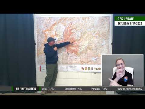
Operations Section Chief Donald Fregulia gives us our daily Operational Update for Saturday, September 17th, 2022 on the Mosquito Fire.
September 17, 2022 at 8:57 AM
NWS Sacramento IMET (Incident Meteorologist) Eric Kurth provides a weather update for Saturday September 17th on the Mosquito Fire.
September 17, 2022 at 8:10 AM
Pursuant to 16 U.S.C. § 551 and 36 C.F.R. § 261.50(a) and (b), and to provide for public safety, the following acts are prohibited within the Truckee Ranger District of the Tahoe National Forest (TNF), and the Lake Tahoe Basin Management Unit (LTBMU). This Order is effective beginning at 5:00 p.m., Pacific Daylight Time, on September 16, 2022, through December 31, 2022.
- Being on National Forest System Road 14N34 (LTBMU) and 16E75 (TNF), also known as the Rubicon Jeep Trail, or McKinney-Rubicon Road, or McKinney Creek-Rubicon Springs Road, as shown on Exhibit A. 36 C.F.R. § 261.54(e).
- Being on a National Forest System Trail 16E75 (TNF) and 14N34 (LTBMU), also known as the Rubicon Jeep Trail, or McKinney-Rubicon Road, or McKinney Creek- Rubicon Springs Road, as shown on Exhibit A. 36 C.F.R. § 261.55(a).

September 17, 2022 at 8:06 AM
Overnight, firefighters continued patrolling and securing control lines in anticipation of increased gusty winds coming into the fire area today ahead of the advancing storm system. Winds are forecasted to peak midafternoon with 20-25 mph gusts along the ridges. These winds will test containment lines and have the potential to spread embers and start spot fires ahead of the eastern flank.
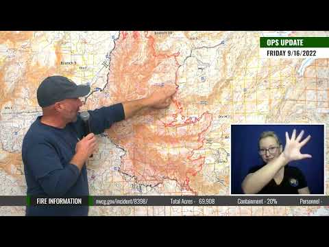
With the moderated fire behavior on Friday and last night due to the smoke inversion, crews and equipment continued constructing direct and indirect control lines to the north and east of the Mosquito Fire. Firefighters face challenging terrain in the North and Middle Forks of the American River to the east of the oncoming fire front. Crews have been successful in their operations to cut off the west and north corners, with the southeast corner fire growth slowing on its own as it burns into the King Fire scar. The burn operation in Middle Fork drainage below Todd Valley has been completed, and crews will continue to monitor and hold their control lines.
The weather changes will be the biggest challenge for firefighters over the next several days. Increased gusty southwest winds will arrive Saturday, with the main weather front and the first round of precipitation forecasted to begin early Sunday. Rainfall is predicted to last through Wednesday, with wetting rain totals nearing 1” by the end of the system. While the rain will help moderate and slow the fire’s growth, it is not forecasted to be a season-ending event. With the critically dry fuels and warmer weather back in the forecast for later next week, firefighters will use this weather system as an opportunity to make significant progress in containing the fire.
September 17, 2022 at 7:12 AM
Projected incident activity: On Saturday, the incoming weather system will bring wind gusts that could spread fire and produce spotting, especially along the ridgelines. Most of the fire will be subdued, though, due to the cooler temperatures and higher humidity.
September 17, 2022 at 6:55 AM
Today’s operations map for the fire. 71,292 acres and 21% contained. 78 structures destroyed, 13 structures damaged as a result of the fire across both counties.
Friday night was cloudless, but heavy smoke did cover the fire area. In the evening, light ridgetop winds were southwest, switching to southeast overnight (2–5 mph). Downcanyon winds were also light (4–7 mph). An inversion developed around midnight; temperatures were cool (around 50 degrees) and humidity recovery was moderate (60–70%). Smoke settled into drainages below the inversion.
Saturday, winds will increase ahead of a cold storm system, gusting up to 25 mph over ridges in the afternoon and early evening. Temperatures will trend cooler and humidity slightly higher. From Sunday into early Wednesday, rain showers are expected, bringing from 0.25–1.0 inches of precipitation. Drier and warmer weather returns Thursday.

September 16, 2022 at 8:02 PM
Cooler temperatures and higher humidity under the smoke layer kept fire behavior substantially lower today. A thick layer of smoke remained over most of the fire area. In eastern areas where the smoke inversion did clear this afternoon, isolated areas of torching and burning occurred. The fire continues to steadily grow on its eastern front primarily near Ramsey Crossing and in the Middle Fork of the American River drainage due to the extremely dry fuels.
Firefighters completed the strategic firing operations along control lines below the community of Todd Valley, securing the fire’s edge into the American River. A small amount of remaining vegetation is slowly burning in the interior of this area. These operations have helped secure the southwest corner of the fire and firefighters will continue to monitor and hold these control lines. Crews continued similar holding operations on the north corner of the fire along Deadwood Road, while crews and heavy equipment took advantage of the moderated fire activity and started constructing direct control lines along portions of the fire’s eastern flank. Great progress continues holding the fire along the Eleven Pines Road. There was no new growth on the southeast corner where the fire has bumped up against the King Fire burn scar.
With the forecast of strong winds coming into the area tomorrow ahead of the incoming weather system, firefighters are completing the critical mission of patrolling and mopping up all hot spots while eliminating any issues that may cause the fire to jump containment lines. In anticipation of the weather, the U.S. Forest Service has responded with two night flying helicopters to assist with reconnaissance and water-dropping capabilities.
September 16, 2022 at 7:31 PM
Matt Jedra, Acting Tahoe National Forest Supervisor: Currently the Placer Grove Big Trees is about three to 4 miles from the edge of the fire. This is the northernmost grove of giant sequoias we have in California. We’ve done a tremendous amount of work over the past couple of days to get this area prepped. We’re looking at doing some prescribed fire through this and doing some raking and some thinning around there. So if fire were to come through there at some point, the trees would be protected at that point and also provide a good defense. Like I said, a lot of resources in there over the past couple of days, and they’re going to be in there until we end up getting this fire front, should it come to that point, to have those trees protected.
September 16, 2022 at 7:10 PM
Fire Behavior Specialist Jonathan Pangburn: “I want to bring up any concerns about the communities Qintette, Volcanoville, Todd Valley, Foresthill, Georgetown and beyond. I do not see any threat to those areas. I do not see any fire progression going there. One, the wind is certainly not in alignment, and two, the firefighting and control efforts have been fantastic out there.”
September 16, 2022 at 6:56 PM
Evening briefing will start at 7:00 pm, you can watch live here.

September 16, 2022 at 6:10 PM
71,292 acres and 20% contained. Repopulation of the Georgetown area is underway.
Currently 2,676 PG&E customers remain without power.
Critical Infrastructure Threat: PG&E Transmission Middle Fork-Gold Hill-230kV and structures, PG&E Transmission Middle Fork #1 60 kV and structures, PG&E Distribution Foresthill 1101 and structures, PG&E Weimar #1-60kV and structures, PG&E Distribution Placerville 2106 and structures, PG&E Distribution Mountain Quarries 2101 and structures, PG&E Asset Roads, Placer County Water Agency Middle Fork Powerhouse, microwave transmission tower, cell towers, radio repeaters, Forest Service Seed Orchard, Placer County Big Trees Grove of Giant Sequoia’s, Grouse Falls, and UC Berkeley’s Blodgett Experimental Forest.
Historical and Cultural Resources: Threat to significant cultural and heritage sites. Historic Western States Trail, Historic Town of Deadwood, Michigan Bluff, Big Gun Diggings, Last Chance, and Westville historical areas.
Watersheds: North Fork American River & Middle Fork American River. The North Fork of the American River is a designated Wild and Scenic River.
Airshed: Placer County APCD & El Dorado County AQMD
Class 1 Airsheds: Hoover Wilderness, Yosemite NP, Emigrant Wilderness, Desolation Wilderness, Lassen-Volcanic NP, Caribou Wilderness
September 16, 2022 at 6:03 PM
Fire behavior Thursday night was moderate. South of Foresthill, crews had a very productive night as they conducted a successful firing operation to secure the southwest side of the fire. In the Chicken Hawk area, they extinguished hotspots along the fireline. Night Operations Chief Don Fregulia reported seeing “no glows” when he patrolled the area early Friday morning. The fireline along the Deadwood Road is also holding nicely. He complimented day-shift firefighters at this morning’s crew briefing: “The direct-suppression work at the head of the fire is evident at night, and we’re very appreciative. You have made up a ton of ground on the east side. While not all the dots connect up just yet, there’s excellent work going on, and it’s really slowing down the progression of the fire to the north and the east.” From the southeast corner westward along the entire southern side, crews patrolled and mopped up hotspots as they encountered them.
September 16, 2022 at 4:56 PM
Per Placer County Sheriff: The Damage Inspections Report (DINS) for Placer County is now complete. The report highlights the results of the inspection of every structure within the perimeter of the fire on the Placer County side.
September 16, 2022 at 4:33 PM
Caltrans update: SR-193 has reopened to traffic between Windwalker Trail and Pilgrim Court in El Dorado County. Please keep in mind that there may still be local road closures in the area
September 16, 2022 at 4:05 PM
Per El Dorado County Sheriff: Effective immediately, portions of Georgetown have been changed to an Evacuation Warning status and repopulation of this area may now occur.
The area west of Wentworth Springs Road at Citabria Lane, North of Greenwood Road and Graybar Mine Road, East of Highway 193 at Sliger Mine Road, and south of Bottle Hill Road and Snow Cap Road. This does not include Sliger Mine Road north of Loriel Drive and Spanish Dry Diggins Road north of Odyssey Falls Drive.
Please be safe when returning home. Be aware of your surroundings as fire and emergency work continue within the county. Also, remember that this is still considered an Evacuation Warning area. This means that there is still threat of fire danger and you should remain prepared to evacuate if the need arises. Those who require extra time to evacuate should remain out of the areas.
The remaining areas under Evacuation Order will continue to have Traffic Control Points and increased security patrols by EDSO and mutual aid. We appreciate your patience during this incident.
Traffic Control Points:
Spanish Dry Diggins Road/ Reservoir Road
Sliger Mine Road/ north of Loriel Drive
Wentworth Springs Road/ Citabria Road
September 16, 2022 at 3:42 PM
An early-season atmospheric river (AR) associated with a cutoff low is forecast to bring precipitation to Northern California and potentially help firefighting efforts at the Mosquito Fire, which has burned nearly 70,000 acres.
Forecast models show the potential for an AR 1 (based on the Ralph et al. 2019 AR Scale) in the foothills of Northern CA near the location of the Mosquito Fire, but there is still uncertainty in the magnitude and duration of AR conditions
GFS and ECMWF ensemble forecasts are showing mean areal precipitation (MAP) over the North Fork American watershed around 1 inch over the next 10 days with considerable spread among individual ensemble members


September 16, 2022 at 3:16 PM
Placer County Health and Human Services and the Placer County Air Pollution Control District have extended the joint air quality advisory through Monday, September 19, 2022, to notify the public of continued poor air quality conditions from smoke from the Mosquito Fire burning in both Placer and El Dorado counties. On Sunday and in the coming days, rain is expected to reduce — but not entirely eliminate — smoke, depending on fire activity.
El Departamento de Salud y Servicios Humanos del Condado de Placer y el Distrito de Control de la Contaminación del Aire del Condado de Placer han extendido el aviso conjunto sobre la calidad del aire hasta el lunes, 19 de septiembre de 2022, para avisar al público sobre las condiciones deficientes del aire debido al humo causado por el incendio Mosquito quemando en los condados de Placer y El Dorado. Se anticipa lluvia en los días que vienen cual reducirá – pero no eliminará – el humo, dependiendo en el nivel de actividad del incendio.
September 16, 2022 at 2:14 PM
No air operations over the fire due to the lingering smoke. Firefighters are continuing to mop up around homes, build and reinforce existing lines in anticipation of tomorrow’s wind event.
September 16, 2022 at 10:45 AM
Still very smoky conditions in Foresthill as of 10:45 am.

September 16, 2022 at 9:13 AM
Fire Behavior Specialist Jonathan Pangburn provides a fire behavior update for Friday, September, 16th, 2022 and an outlook on tomorrow’s forecasted wind and rain event.

September 16, 2022 at 9:12 AM
Operations Section Chief Donald Fregulia gives us our daily Operational Update for September 16th, 2022 on the Mosquito Fire.
September 16, 2022 at 7:38 AM
Firefighters continued to hold the Mosquito Fire within existing control lines along its western and southern flanks. The aggressive work of firefighters has minimized damage and further spread into affected communities along the fire’s edge. With the threat of stronger winds in the coming days due to an incoming cold front, crews will relentlessly patrol the fire’s perimeter for heat, smoke, and any potential issues that could cause the fire to jump containment lines. On September 13th, firefighters and the public saw firsthand how quickly a spot fire could jump control lines and threaten the communities again with little to no time to escape.
On Thursday, the fire’s eastern flank remained active with steady growth towards the Ramsey Crossing area. There, crews are using defensive firing operations along the Eleven Pines Road and control lines running south through Devil’s Peak to stop the fire’s growth towards McCulloh. Firefighters have continued work to hook the fire around the southeast corner by constructing control lines and using strategic firing operations when possible in the Stumpy Meadows area. Crews plan to utilize the Wentworth Springs Road as well as hand and dozer lines moving north across the Rubicon River drainage. With increased smoke shading on the northern portion of the fire, firefighters have made progress in holding their control lines along Deadwood Road.
The persistent southwest winds will continue and become even stronger as the approaching cold front arrives this weekend. Cooler temperatures, higher humidity, and wetting rains are forecasted for Sunday and lasting into early next week. Firefighters will welcome precipitation, but the stronger winds have the potential to cast embers farther out in front of the fire. Crews will continue the difficult work of constructing primary and contingency lines ahead of the north and eastern portions of the fire. With multiple steep and rugged river drainages to navigate, creating contingency lines will provide firefighters and communities with a secondary safety net should the fire jump primary control lines.
People Evacuated: 11,277
Structures Threatened: 9,236
Total Structures Destroyed: 73
Total Structures Damaged: 13
Total Personnel: 3,873
September 16, 2022 at 7:33 AM
Today, southwest winds continue but decrease in intensity from 4 to 7 mph with gusts to 13 mph. Temperatures and humidity levels remain similar to previous days. A cold system will bring increased southwest winds on Saturday, gusting up to 25 mph over ridges. Temperatures will trend cooler and humidity higher. There is a chance of rain showers starting Sunday into mid-week, with wetting rain expected. Over 0.25″ total is possible.
Weak ridging Friday will lead to a bit more air stability, warming of surface temperatures a few degrees, and a little drying. Heavy smoke will continue to influence fire behavior. Areas shaded by smoke will stay cooler and dampen fire activity. Fire behavior today is expected to be similar to Thursday’s.
September 16, 2022 at 5:53 AM
Today’s ops map, useful for following along in briefing or if listening to radio traffic. Note the substantial increase in completed line on the west side. Moderate fire behavior with backing, flanking, and creeping observed overnight.

September 15, 2022 at 7:15 PM
Fire Behavior Analyst (FBAN) report during the virtual briefing:
In advance of an upcoming trough or slightly colder and wetter system coming in, we’re going to have some stronger winds. Tomorrow is a little bit similar to today. And then starting Saturday we’re going to have a stronger wind system but increased humidity and lower temperatures. It’s going to get much colder as the system comes in from the Gulf of Alaska and comes down into continental United States and really changes the system for us here. Somewhere around Saturday night to Sunday morning, we should be seeing some precipitation, some measurable wedding rains through Tuesday, possibly into Wednesday period, there’s about an 80% chance of at least a quarter inch. And at this point the weather service is forecasting about a 50% chance of possibly greater than an inch of rain. But that is of course, over multiple days. So it’s a little bit of showers here and then a break and a little bit of showers again. So it’s not all one large rain event. And that’s a bit of a mixed blessing here.
The increased winds are certainly not going to be favorable. That is going to continue to have the possibility to throw more embers in front of this fire and create spot fires, which would not be helpful. But on the other hand, of course, the moisture is a welcome relief for all of us in drought stricken California.
So how does that affect fire behavior? Well. First and foremost before that system comes. This area in the northeast, so kind of the Deadwood and Chicken Hawk and out Foresthill Road into the Northeast. We’re seeing a lot of smoke impacts where the wind is pushing the smoke over another part of the fire and it’s starting to settle that down. Which is helping the firefighters with some more of their mop up activity for those lines you heard discussed that are going to be really important for taking any seam out of it if it tries to make a run past Foresthill Road.
The smoke is coming from this area down here though in the Ramsey Crossing down to Devil’s Peak and not quite the Stumpy Meadows, but really more of this Devil’s Peak/Ramsey Crossing area that right there is creating the greatest amount of growth on the fire.
If you’re looking especially from down the hill and you see some plumes of smoke start to rise above the general rest of the haze that’s generally these areas right here developing the most. It’s growing about maybe half mile a day and it’s starting to chunk in front of itself.
I just want to address something that I mentioned before. The fuels are very dry. As you know, we’ve been in the drought and we had a record heat wave and so the cooler temperatures and the lighter winds are certainly helpful for not spreading the fire as fast as it had been traveling. But the difficulty of control out in the heavier fuel loading in this particular area is going to continue to create a challenge. And that’s why you just heard the plan for not only one line coming down here, but multiple redundancies and secondary contingencies to make sure that we have a good opportunity to stop the fire.
And then, of course, I want to address the primary concern in communities from Quintette, the Georgetown Divide, Volcano Area, Volcanoville, Foresthill, Todd Valley, all of those no movement expected. The piece that is still being burned in here next to Todd Valley estate is going very, very well. That’s been backing down the hill and has been quite a successful operation to this point.
September 15, 2022 at 6:56 PM
Evening briefing starting at 7:00 pm

September 15, 2022 at 6:54 PM
The official evening update:
Firefighters focused on securing the west corner of the fire down in the Middle Fork of the American River below the communities of Todd Valley and Foresthill. Crews are finishing the last remaining portions of firing operations along the control lines that tie into the river. Unmanned Aerial Systems (UAS) are assisting ground resources with aerial ignitions to strategically burn remaining vegetation inside control lines to secure.
Firefighters are working diligently along the western edge of the fire along the Foresthill Road corridor to mop up and secure all control lines to mitigate any threats of slop overs. On the north corner of the fire, crews worked throughout the day to hold and secure the control lines along the Foresthill Divide the Deadwood Roads where strategic firing operations took place last night. These actions are crucial in holding the fire south of Westville. Critically dry fuels continue to fuel the Mosquito Fire’s steady growth to the east. Crews, dozers, and heavy equipment continue the dangerous and grueling task of building indirect control lines in steep and rugged terrain. Crews are also utilizing existing roads systems, such as the Eleven Pines Road, to assist in building a solid control line to hold advancing fire. Crews are constructing a combination of dozer and hand lines from Wentworth Springs Road north towards Devil’s Peak in the effort of holding fire in the Rubicon River drainage. Firefighters continue to mop up remaining hot spots and patrol the southern edge of the fire along Volcanoville Road. Cooperators and utility companies continue work in these areas to assess and start needed infrastructure repair with the goal of repopulating the communities as soon as it becomes safe to do so.
An incoming weather system is forecasted to bring increased winds and precipitation into the fire area starting Saturday and into early next week. Firefighters will continue to strengthen and secure all control lines in preparation for these changing conditions.
September 15, 2022 at 6:22 PM
The fire was mapped at 67,668 acres at 4pm. Most active today in the Stumpy Meadows and the firing operations in the Westville area where Foresthill Road and Deadwood Road are joining.
September 15, 2022 at 6:11 PM
Additional scooper drops on the north side of the Rubicon and Ramsey Crossing, aided by helicopters.
September 15, 2022 at 6:08 PM
September 15, 2022 at 6:05 PM
Tankers are reinforcing the dozer and handline along Foresthill Road on the northeastern point of the fire near Westville.
September 15, 2022 at 1:24 PM
No drone sightings within the last 30 minutes. Air operations will resume.
September 15, 2022 at 12:54 PM
Drone sighting near the Georgetown Mobile Retardant Base, law enforcement is in the area now. Drone incursions mean suspending air operations in the area.

September 15, 2022 at 12:08 PM
The firing operation at the north point of the fire is proceeding – not ideal burn conditions with higher relative humidity and cooler temperatures.

September 15, 2022 at 12:06 PM
Ira Graves from Air Operations provides an overview of equipment including the following: Air Tankers DC-10, MD-107, RJ-85, Helicopters S-70I, Lakota UH-72A, Scooper CL-415, UAS / Drone Type 3 – M600, Type 4 – Mavic Pro

September 15, 2022 at 11:16 AM
The public operations briefing

September 15, 2022 at 8:49 AM
A few photos taken near the Foresthill transfer station this morning.


September 15, 2022 at 7:35 AM
Today’s priorities remain securing each of the three corners of the fire. Firefighters have been very successful in holding the control lines along the communities of Todd Valley and Foresthill despite challenging fire conditions on Tuesday. Crews will continue extensive mop-up operations in those areas, the Foresthill Road corridor, and on the portions of line to the north of Volcanoville. Southwest winds have been favorable for the communities along Volcanoville Road, but firefighters remain in the areas to ensure the fire does not spot across containment lines. These mop-up operations include firefighters using hose lines, water, and hand tools to thoroughly extinguish or remove remaining burning material well inside the fire’s edge. This is to ensure that no smoldering debris will roll, fall, or fly over the containment lines and start a spot fire. With the critically dry fuels in the area, it only takes a small ember to start a spot fire and spread rapidly in the steep terrain.
September 15, 2022 at 7:35 AM
Overnight, smoke settled back into drainages due to easing winds, with a majority of the fire area seeing good humidity recovery. Firefighters continued working throughout the night, patrolling, mopping up, and securing control lines around the south and east sides of the fire. Crews and heavy equipment, including a large number of dozers, continued constructing indirect lines adjacent to steep and rugged terrain to the east of the main firefront.
Firefighters remain engaged on the north side of the fire near Deadwood Road. Crews continued bringing strategic firing operations down the Deadwood Road from the Foresthill Divide Road with the intention of stopping the fire’s northern spread. Firefighters were conducting similar operations on the southeast corner of the fire near Stumpy Meadows by constructing control lines and utilizing firing operations to secure them.
September 15, 2022 at 6:51 AM
Weather forecast: Onshore flow continues today with lighter southwest ridge winds for the afternoon. Mostly sunny conditions and good ventilation will bring quite a lot of sun on the fuels, except for areas shaded by smoke. Temperatures will be cool again today and will be below normal for mid-September. Humidity values will trend higher with continued onshore flow, but these features will likely be offset by the increased sunshine, early inversion break and increased southwesterly ridgetop winds.
Outlook for Friday: Southwest ridgetop winds with gusts to 1 O mph. Temperatures will be seasonably cool in the 60s and lower 70s. Afternoon humidity 28-45% with moderate night time recovery to around 60%.
Cooler weather is expected Saturday, with highs in the 60s and increasing southwest ridge winds gusting to 20 mph. Periods of rain showers are possible late Saturday night into early next week and could potentially bring wetting rain.
Fire behavior separated by two distinct zones:
Clear air: group torching and upslope/ridgeline runs; smolder under smoke.
Air operations: Clear air in the south; smoke impacts in the north.
September 15, 2022 at 6:15 AM
Today’s briefing map

September 14, 2022 at 7:31 PM
Operations update from the briefing: “I’d like to start down here in the Quintet area. We’ve had really good success with our containment line, getting in there, mopping them up, getting in there, really feeling stirring and drowning and putting out that fire all along here, coming out to Volcanoville, along the Volcanoville Road and then out and down into the Middle Fork of the American River. When we start getting down into this area of the Middle Fork, there’s still a lot of work to be done down in that river canyon, getting in there, reinforcing that line, mopping that up and really making sure that fire is controlled. And then coming up out of the Middle Fork towards Forest Hill and then out the Forest Hill Road to the east and out towards Michigan Bluff Road, same thing. Getting in there, making sure that this fire is really out and that this containment line is going to hold. And that’s a high priority for us because that’s how we’re going to be able to give our thumbs up and say it’s safe to the sheriffs that we’re working with for you to get back in there. And so we’re daily working with those sheriffs, coordinating what’s going on on the ground so that we can work towards that end. When you start getting out past Michigan Bluff Road in the Chicken Hawk Ridge area in the seed orchard, we’re still working with an active fire edge across the entire eastern edge of the fire. What we’re doing out here is a combination of efforts where we’re using what’s called a tactical firing operation and we’re putting fire down to create a wider fire break then we could just with Dozers or with a hand crew. So if the fire strikes coming out of these creeks or the river drainage down there has something to run into, loose and see and not cross the road. Where we’re really working out right now is where we’re going to be coming around out by Robinson Flat and down south towards French Meadows Reservoir, getting that prepared, giving ourselves plenty of time to be successful in keeping this fire as small as possible. When you come down from French Meadows, one of the biggest obstacles we’ve got is the North Fork of the Middle Fork of the American River. Steep, rocky, nasty terrain. It’s just not safe to put people in and we just don’t have the time with the fire spread to really get in there safely and effectively and get that done. Right now we’re looking at opportunities in the American Hill area to tighten that up. But when you get right down to it, right now we’re having to look out here, coming down into here, we start getting into the Middle Fork of the American River and being able to bring that down on the south side of the river in here. We’ve been coordinating with SPI we’ve got a lot of firefighters out there finding ways to start bringing this fire line together. Having a really good plan, bringing it down towards the Rubicon River and done some really good work down here in the Rubicon. Found a very improbable place where we’re anticipating this success. Several miles further to the west than we initially anticipated in getting across that river with our line and expecting it to hold and then tying that into wet worth brings road into something better. Thank you.”

September 14, 2022 at 6:56 PM
The virtual evening briefing will start at 7:00 pm.
Firefighters continue to hold the Mosquito Fire inside established control lines with the help of cooler temperatures and higher humidity. Throughout the day, crews continued to patrol, mop up and secure control lines along the Foresthill Road corridor, with a heavy focus on the area where yesterday’s spot fire made an aggressive run towards the community. Aerial reconnaissance shows very little smoke production in the areas below the communities of Foresthill and Michigan Bluff. Successful firing operations continue to take place along Deadwood Road to cut off the fire’s growth to the north.
The Mosquito Fire’s eastern front continues to steadily grow with active fire behavior into dense forested areas with critically dry fuels and little fire history. A majority of the fire’s smoke column today was produced by the fire activity in the Middle Fork of the American River on the east side. Dozers and heavy equipment worked throughout the day to continue expanding control lines to stop the fire’s eastwardly growth. On the southeast corner of the fire near Stumpy Meadows, crews constructed control lines in an effort to cut off the fire in the Rubicon River drainage. The southern portion of the fire continues to hold with firefighters constantly patrolling all portions of these control lines and mopping up hot spots well into the interior of the fire perimeter to ensure there is no threat of escape.
Today’s southwesterly winds were lighter than Tuesday, but still provided the needed air mixing to push the smoke inversion out of the fire area. With this clearer air, aircraft assigned to the incident were able to be used heavily for various operations around the fire. Helicopters have been busy throughout the day conducting water and retardant dropping missions in order to assist ground crews in extinguishing hot spots and preventing fire growth. Multiple mobile retardant bases are located around the fire to assist helicopters with quick refilling of fire retardant. Multiple Unmanned Aerial Systems (UAS) are being used to assist with reconnaissance, mapping, and infrared capabilities to assist firefighters in locating hot spots near the fire’s edge.
September 14, 2022 at 6:17 PM
11,277 people remain evacuated, no additional evacuations today and no injuries to firefighters reported.
September 14, 2022 at 5:52 PM
Air Attack talking to the ground resources above Stumpy Meadows, Super Scoopers are returning to Lake Tahoe for the evening. No active flame visible in their mission area.
September 14, 2022 at 5:38 PM
Latest FIRIS mapping has the fire at 63,427 acres, growth was mostly to the southeast between French Meadows Road and Blacksmith Flat and the eastern portion of the fire.
September 14, 2022 at 4:27 PM
The Super Scoopers are back, dipping out of Union Valley Reservoir and dropping above Stumpy Meadows. The southeast corner of the fire is one of today’s priorities.
September 14, 2022 at 3:52 PM
FIRIS mapping plane has arrived, joining the airshow over the fire. TNF Air Attack 17 has handed the fire over to CAL FIRE AA 230 and is returning to Grass Valley after being on the fire since early this morning.
September 14, 2022 at 2:23 PM

Tankers are accelerating retardant drops in the Middle Fork below Todd Valley, some reburn occcuring.
September 14, 2022 at 1:28 PM
Missions are proceeding as assigned on the fire today. While activity is picking up, Foresthill Road is holding and work in the Stumpy Meadows area is progressing.
September 14, 2022 at 12:04 PM
The two Super Scoopers 261 and 263 are assigned to the fire and dipping out of Union Valley Reservoir. They are dropping above Stumpy Meadows.
September 14, 2022 at 10:49 AM
Air operations update
September 14, 2022 at 9:15 AM
Air Attack is over the fire and reports everything looks good on Foresthill Road, nothing on the north side of the road. Firefighters are stretched out along Todd Valley and mopping up, doing great work on that line.
September 14, 2022 at 8:55 AM
Overnight, firefighters successfully held the fire within control lines along the southern edge of Foresthill and Todd Valley. On the northwest corner, crews were able to continue strategic firing operations along control lines from the Foresthill Divide Road to Deadwood Road. This four-mile stretch of line is crucial for helping hook and stop the fire’s northern spread. A large number of dozers and heavy equipment continued to work through the night in the areas to the east of the fire to build indirect control lines ahead of the advancing fire front. The fire remains active on this eastern front, steadily burning and advancing in heavy unburned fuels.
Today’s number one priority remains strengthening and securing the southwest corner of the fire to protect and defend the communities of Foresthill and Todd Valley. Firefighters are prepared to actively engage in structure defense along the edges of these communities should the fire make similar runs as it did on Tuesday. Weather conditions are forecasted to be the same today with continued southwest winds, which will lead to clear skies and better ventilation for fire growth.
September 14, 2022 at 7:39 AM
The fire was active Tuesday night into Wednesday morning, particularly on the northeast side. Night-shift crews completed firing operations on the north side from Forks House Trailhead to the Deadwood Road. On the west side, south of Foresthill where the fire spotted over the Middle Fork of the American River Tuesday afternoon, fire activity did moderate overnight. The mission-critical priority for firefighters Wednesday is the west side of the fire; they will focus on protecting structures in the Foresthill and Todd Valley areas and increasing containment of the fireline to prevent further westward and northward spread. The southeast corner is also a priority as crews strive to halt the fire’s progression toward Stumpy Meadows. Numerous aircraft are supporting ground crews, conducting water and retardant drops during both day and night shifts.
September 14, 2022 at 7:33 AM
FIRIS mapping the fire at 61,012 acres this morning.
September 14, 2022 at 7:31 AM
Everything looks good at Worton’s Market on Foresthill Road this morning.

September 14, 2022 at 7:03 AM
Containment has decreased to 20%. Fire behavior Tuesday night was active, consisting of backing, uphill runs, and group-tree torching. The fire remained active throughout the night into Wednesday morning. Conditions facilitated the firing operations that necessary to secure several miles of containment line.
September 14, 2022 at 6:39 AM
Updated perimeter might be coming soon, FIRIS is over the incident again.
A weak weather system will exit the area today bringing continued breezy southwest winds for the afternoon. This should break the inversion early and ventilate the fire after 1300 hours. Mostly sunny conditions and good ventilation will bring quite a lot of sun on the fuels. Temperatures will cool further today and will be below normal for mid-September. Humidity values will trend higher with continued onshore flow, but these features will likely be offset by the increased sunshine, early inversion break and increased southwesterly ridgetop winds.
Weather outlook for Thursday: A dry cold front on Wednesday will bring breezy Southwest ridgetop winds with gusts 20-25 mph possible. The stronger winds and cooling aloft should allow the inversion to break early with a longer afternoon burn period. Temperatures will be seasonably cool in the 70s and lower 80s. Afternoon humidity 25-35% with moderate night time recovery to around 60%.
September 14, 2022 at 5:10 AM
The fire was mapped overnight at 58,544 acres.

September 13, 2022 at 8:08 PM
Latest FIRIS mapping puts the fire at 57,999 acres.
September 13, 2022 at 7:42 PM
Fire activity increased as anticipated Tuesday, particularly on the southeast side near Buckeye Point and the northeast and east sides. The fire remains south of Foresthill Road. However, the twists and turns of the American River near Buckeye Point channeled and swirled the winds in such a way that burning embers were caught up and carried in the wind across the river and ignited a spot fire. As of Tuesday evening, the incident management team has received NO reports of spot fires on the north side of Foresthill Road. Clear skies allowed aircraft to fly numerous missions today as they assisted ground crews in the firefight.
Light downcanyon winds early into the evening may be problematic for the spot fire on the southwest side near Buckeye Point.
Smoke will settle into the drainages overnight Tuesday. Humidity recovery will be around 70% with low temperatures in the mid 50s to around 60. Southwest evening winds will turn light downcanyon overnight. On Wednesday, breezy southwest winds return in the afternoon with gusts to 15 to 20 mph. High temperatures should be about 5 degrees cooler, and humidity will trend up.
September 13, 2022 at 7:23 PM
Fire behavior analyst at the briefing: “We still have the winds out of the southwest pushing to the northeast. They’re not dramatically strong, but they’re strong enough to give clear air. What that means is that it’s going to continue to have potential for progression out in this northeastern portion of the area of the fire. As we move down on the southern end of the Middle Fork of the American River and out toward the Rubicon River, we’re really seeing the effects of that wind as well, pushing it away from Stumpy Meadows Reservoir. Thankfully, I know a lot of firefighters are in there trying to make sure to stop the southward expansion to more values at risk and the wind is helping with that in terms of the containment toward the south and helping to drive it into more of the forested area where they are again trying to turn the corner. And I want to finally touch on the communities to the south, Quintette, Volcanoville and past the Georgetown Divide and into Georgetown and beyond into El Dorado County. Two things are happening there. One, we have a lot of firefighting going on, trying to make sure to take the heat out of any of the fire that had been in this area southwestern portion of the fire. And two, the wind is thankfully in our favor, again, trying to push away from there. “
September 13, 2022 at 7:11 PM
Today’s slightly stronger southwest winds aloft broke up the smoke inversion that has been hanging over the Mosquito Fire for the past several days. With the smoke inversion clearing out by midday, the fire actively increased significantly this afternoon due to the increased ventilation and available oxygen to support burning.
This afternoon, a spot fire jumped the Middle Fork of the American River on the west corner of the fire’s perimeter in the Pond Creek Drainage. Due to the critically dry fuels, steep terrain, and increased ventilation, the spot fire grew rapidly towards the community of Foresthill. Firefighters and resources from around the fire have been diverted to assist with holding this corner of the fire at the contingency lines that have been put in place by crews over the past week below the community. Firefighters and a large aircraft contingency, including both fixed and rotor wing aircraft, have been engaging in active structure defense, defensive firing operations, and working to hold the advancing spot fire at control lines and protect the surrounding communities.
The fire also remained active on the north corner of the fire just north of Chicken Hawk Road. Crews continue to actively construct control lines and utilize strategic firing operations when possible in an effort to hook this corner and cut off its growth to the north. The Mosquito Fire continues to advance steadily to the east in heavily forested areas with extremely dry vegetation. Crews continue to construct indirect lines and utilize existing road systems ahead of the advancing fire to cut off the fire’s growth to the east. On the southeast corner of the fire, the fire’s edge continues to move towards Stumpy Meadows where firefighters are being challenged with difficult terrain and opportunities to stop the fire in the Rubicon River drainage.
Southwest winds and cooler temperatures continue to be forecasted for the next several days which should create similar weather conditions as seen on Tuesday, thus clearing the smoke inversion earlier in the day.
September 13, 2022 at 6:55 PM
Virtual meeting starts at 7:00 pm.
September 13, 2022 at 6:49 PM
The firing operation and the incessant retardant drops held the fire at Foresthill Road.

September 13, 2022 at 6:26 PM
FIRIS is over the fire again, mapping the east side of the fire now. Containment is up to 25%. 3,052 firefighters assigned. Closures remain for Foresthill Union and Black Oak Unified school districts.
September 13, 2022 at 5:54 PM
Structure protection on Foresthill Road.

September 13, 2022 at 5:40 PM
Firefighters are holding it at Baltimore Mine and Foresthill Road.


September 13, 2022 at 5:30 PM
Backfiring behind Worton’s Market now. Updated total acreage is now 50,330.


September 13, 2022 at 5:24 PM
Additional resources to the Foresthill Mobile Home Park, 3 engines engaged, additional engines and a dozer dispatched.
September 13, 2022 at 5:11 PM
Firefighters at the end of Isabell Lane in Todd Valley report no spotting in the area.
Zone 26 is now under an evacuation warning (downgrade): South of Iowa Hill Rd at Mineral Bar, west of Elliott Ranch Rd, north of Big Dipper, east of the North Fork of the American River/Camels Hump
September 13, 2022 at 5:01 PM
Firefighters are holding the fire at Foresthill Road, nine LATs are working the spot now. Helicopters will use the “square dip” which is the town’s water supply.

September 13, 2022 at 4:55 PM
Some vehicles and a structure now fully involved on Baltimore Mine Road, requesting helicopters to cool down the area for firefighters.
September 13, 2022 at 4:53 PM
Foresthill Road and the dozer line next to it looking towards Baltimore Mine Road. Firing operations progressing as planned.


September 13, 2022 at 4:45 PM
Firing operations continue, structure group catching spots.

September 13, 2022 at 4:39 PM
Spotting reported across the dozerline on Baltimore Mine Road and Foresthill Road.
September 13, 2022 at 4:28 PM
On Baltimore Mine Road, right now.

September 13, 2022 at 4:23 PM
Firing operation has begun, firing off Foresthill Road down from Worton’s Market and the Foresthill School. Watching for spots across Foresthill Road, structure protection is the priority.
September 13, 2022 at 4:13 PM
Zone 11A : Mandatory Evacuation
Active Date/Time: 9/13/2022 3:30 PM
Yankee Jims Rd to the American River to Kings Hill Rd to Big Dipper Rd to Iowa Hill Rd south to Yankee Jims Rd
September 13, 2022 at 4:07 PM
Additional drop between Worton’s Market and Baltimore Mine Rd. Foresthill structure protection group has formed up.

September 13, 2022 at 4:03 PM
September 13, 2022 at 3:58 PM
Multiple retardant drops on the head of the 300+ acre spot fire, as seen from Worton’s Market.

September 13, 2022 at 3:43 PM
Spot fire now mapped by FIRIS at 302.57 acres.

September 13, 2022 at 3:37 PM
Three VLATS arriving over the fire.
September 13, 2022 at 3:15 PM
Spot fire below Todd Valley mapped at 93.5 acres at 2:52 pm.
September 13, 2022 at 2:55 PM
Making a run, no divert on tankers.

September 13, 2022 at 2:51 PM
Power secured all the way from upper Todd Valley to Michigan bluff.
September 13, 2022 at 2:45 PM
Structure protection group for Foresthill, assembling at Foresthill Fire Dept.
September 13, 2022 at 2:43 PM
20 additional engines requested immediate need.
September 13, 2022 at 2:38 PM
Soon, there will be an immediate structure threat in the area of Worton’s Market. VLAT requested.
September 13, 2022 at 2:32 PM
Spot fire below Todd Valley now well established, requesting additional air resources, immediate need.
September 13, 2022 at 2:31 PM
Due to the Mosquito Fire there is a Mandatory Evacuation Order in place for the Stumpy Meadows area. The boundaries for the evacuated area are East of Stumpy Meadows, West of the Wentworth Springs Road and Ice Hours Road intersection. South of the County Boarder, North of Onion Creek. Please evacuate the area using Southbound Ice House Road towards Highway 50. There are shelters located the Cameron Park CSD and Green Valley Church in Placerville. Please drive safe there are emergency responders in the area.
September 13, 2022 at 2:28 PM
Spot fire across the Middle Fork below Todd Valley, approximately 5 acres.
September 13, 2022 at 10:43 AM
Engines and equipment moving out of Baltimore Mine Road, others are on their way to today’s missions.


September 13, 2022 at 8:35 AM
Placer County Health and Human Services and the Placer County Air Pollution Control District have extended the joint air quality advisory through Friday, September 16, 2022, to notify the public of continued poor air quality conditions from smoke from the Mosquito Fire in both Placer and El Dorado counties.
September 13, 2022 at 7:42 AM
Already relatively clear skies in Foresthill. In keeping with the projected incident activity, atmospheric mixing will continue to increase, allowing the fire to breathe. The extremely dry vegetation, stressed by the record-breaking September heat wave, will generate even more heat as it burns, which will lead to more mixing and air flow. Sunny skies will allow a smoke plume to develop as record-breaking dry large vegetation is consumed and the fire moves into remote, rugged terrain.

September 13, 2022 at 7:27 AM
Firefighters working on the fire’s southwest side between Foresthill and Volcanoville, had a very successful day Monday. They completed an important firing operation from Buckeye Peak to the American River that had been shut down by high humidity and some precipitation the previous night. Fire was most active on the north and east sides. Aircraft were able to flight late Monday afternoon but were mostly hampered by poor visibility.
September 13, 2022 at 4:54 AM
The fire was mapped at 49,671 acres last night. Today’s day briefing map is below. There has been no change in the control objectives:
- Keep the fire North of Wentworth Springs Road.
- Keep the fire South of Foresthill Road.
- Keep the fire East of Drivers Flat Road.
- Keep the fire West of Eleven Pines.

September 12, 2022 at 7:17 PM
Some notes from the briefing regarding fire behavior: There was a slight mixing of the air with a little bit of wind movement. Today we specifically had that persistent southwest flow that’s starting to push the fire deeper into the forested areas. But that’s good news for the communities such as the Forest Hill, Volcanoville and Quintet communities. Moving up into this northeastern portion of the fire. We observed fire coming up into the crowns of trees or torching in groups and it really started to move with some of the limited airflow that we have today, we’re expecting that airflow to increase a little bit tomorrow and especially into Wednesday. So we’re expecting a little bit of an uptick in fire behavior and I want to touch on that. We are seeing historically dry fuels.
September 12, 2022 at 7:01 PM
Evening briefing
September 12, 2022 at 6:58 PM
Per Placer County: Tomorrow, animal sheltering operations related to the Mosquito Fire will move from the Nevada County Fairgrounds to the Gold Country Fairgrounds in Auburn. All animals currently in Nevada County are being safely, calmly transported by our staff and mutual aid partners. Intake of new animals will briefly be suspended on Tuesday to accommodate the move and will resume on Wednesday, 9/14, at the Gold Country Fairgrounds. (For urgent needs, please contact our field services dispatch at 530-886-5500 #2. Animal Control Officers will continue to help) Starting Wednesday, large and small animals can be brought to:
Gold Country Fairgrounds
209 Fairgate Rd, Auburn (Enter via Gate 3 on Pleasant Ave.)
*No chickens/poultry due to avian flu.
Our Animal Services Center on B. Ave in Auburn is still at capacity with animals and not accepting new intakes. We appreciate the partnership of both fairgrounds locations as we’ve navigated this evolving incident. Thank you to our whole community for keeping our fur babies safe!
September 12, 2022 at 6:26 PM
Containment is now at 16%.
11,260 people remain evacuated.
The Damage Inspection Team has concluded assessment of portions of the fire, and numbers of damaged or destroyed structures are listed. The team will continue to assess other areas as fire conditions allow.
25 single residences destroyed, 3 damaged.
21 minor structures destroyed, 1 damaged.
Mail for those evacuated due to the fire can retrieve their mail at the Auburn main post office at 371 Nevada St. in Auburn.
September 12, 2022 at 5:03 PM
El Dorado County Sheriff is making damage assessment reports available. Also, evacuees can call 530-621-5795 to ask an Animal Services Officer to go to their property to feed and water their animals.
September 12, 2022 at 3:19 PM
September 12, 2022 at 3:13 PM
Some precip occurring over Division KK, firefighters should get their vehicles and equipment back on the pavement to avoid getting mired in muck though rain is unlikely to last.
September 12, 2022 at 1:13 PM
From Placer County Sheriff: Update for the residents of the Michigan Bluff Community: If you are a resident of the Michigan Bluff Community in Foresthill & live south of the intersection of Michigan Bluff Rd & Chickenhawk Rd please call 530-886-5390 to speak to a representative for updated information.
September 12, 2022 at 1:10 PM
Sign posted at the Foresthill Elementary School where engines are currently staging.


September 12, 2022 at 12:53 PM
The public ops briefing

September 12, 2022 at 8:38 AM
Projected incident activity:
12-hour time frame:
Increased transport winds and better mixing will allow ventilation, although cooler temperatures and higher relative humidity will lessen this impact. Still, increased fire behavior is anticipated, especially with the southwest flow driving the fire upslope and into canyons. Deadwood Ridge, Chicken Hawk Ridge, Ralston Ridge, Long Canyon, Middle Fork American River, and Rubicon River start to come into alignment for fire spread.
24-hour time frame:
Atmospheric mixing continues to increase, allowing the fire to breathe. The extremely dry vegetation, stressed by the record-breaking September heat wave, will generate even more heat as it burns, which will lead to more mixing and air flow. Sunny skies will allow a smoke plume to develop as record-breaking dry large vegetation is consumed and the fire moves into remote, rugged terrain.
September 12, 2022 at 7:52 AM
The Mosquito Fire continues to progress primarily to the north and east. Despite cooler temperatures, the historically dry fuel moisture in the vegetation continues driving the fire’s growth. On Sunday, the fire made a run to the northeast in the drainage between Foresthill Road and Deadwood Road. Firefighters have been building in-direct control lines and when necessary utilizing strategic firing operations to stay ahead of the fire on this corner.
Crews continue to look for opportunities to build in-direct control lines between the eastern front of the fire and Last Chance. The steep and rugged terrain make it difficult for ground crews to access the fire directly, therefore building control lines ahead of the approaching fire and building a buffer with defensive firing operations will allow firefighters the opportunity to slow and potentially stop the fire’s forward progress.
There was no significant growth on the southeast corner of the fire on Sunday, which gave crews more time to construct control lines coming out of Stumpy Meadows. Over the past few shifts, firefighters have been successful in securing containment lines on the southern edge along Volcano Road and to the north of Quintette. Crews continue to monitor these areas as well as strengthening the remaining control lines along this southern boundary to gain more containment.
Firefighters continue to work towards hooking the southwest corner near Buckeye Point. Crews have successfully built a control line consisting of dozer and hand lines to the Middle Fork of the American River. This control line, in combination with firing operations, will help firefighters secure this piece of the fire perimeter. Locking in this southwest corner of the fire is today’s top priority for firefighters. Crews are also in the area of Todd Valley working to build contingency lines to further protect the community of Foresthill.


September 12, 2022 at 6:34 AM
No significant change in acreage overnight. Today’s briefing map is below. A detailed ops map is here as a pdf file (10MB).

September 11, 2022 at 7:15 PM
People Evacuated: 11,260
Structures Threatened: Approximately 5,848
As anticipated, fire activity and smoke production increased Sunday afternoon after the inversion lifted over much of the fire. However, thunderstorms remained south of US Highway 50 and did not affect the fire. Other conditions that often lead to active fire behavior, such as hot, dry, windy weather, have not been present recently nor are they expected to materialize this week. The incident’s fire behavior analyst cautions, however, that “while this is not a weather show, it is a fuels show.” All the vegetation—from fine grass to big trees—is extremely dry and burning readily. Incident Commander Rick Young went on a reconnaissance flight Sunday afternoon and confirmed that “the fire wasn’t going anywhere fast (i.e., not wind driven), but where it was burning, it was really burning.”

Helicopters flew water-dropping missions Sunday afternoon, providing assistance to firefighters on the ground, primarily on the western perimeter near Foresthill and the northern side near Deadwood Road where the fire was quite active along portions of the Western States Trail.
All around the fire’s perimeter, crews are using a combination of direct- and indirect-suppression tactics. As much as they are able, they are constructing fireline close to the fire and directly extinguishing the flames. Elsewhere, they are constructing handline and dozer line away from the fire’s edge and conducting firing operations to create a buffer and reduce the likelihood of the fire making out-of-control runs across the landscape. On the fire’s east side, for example, crews are removing trees and brush from firelines that were constructed during the American and King fires.
Firefighters will remain on the fireline throughout the night, protecting communities, extinguishing hotspots, patrolling, and conducting firing operations as weather conditions allow.
September 11, 2022 at 7:02 PM
Evening briefing

September 11, 2022 at 9:25 PM
Firefighters are hoping to take advantage of better nighttime recovery to continue with firing operations where conditions are right and preparations are complete. Nighthawk recon helicopter is over the fire, providing real-time intel to ground resources.

September 11, 2022 at 8:09 PM
IC Rick Young: “I want to assure you we are implementing a very aggressive full suppression strategy with the intent to get you back into your home quickly as possible. But it’s a process. There’s lots of things that need to occur. First, the fire needs to be lined, and with currently over 80 miles of fire perimeter, all of which needs to be lined, mopped up, patrolled by firefighters that are out there working 24 hours a day, it still takes a lot of time. So I ask you for your patience as we continue to work as diligently as we can to make that happen.”
September 11, 2022 at 7:35 PM
In the briefing just now, NEU Unit Chief Brian Estates has good news for Placer County: ” The forward progress of the fire in Placer County has been stopped to the west and we are securing that and we will maintain that security of that fire. The entirety of the fire line underneath Forest Hill from Baltimore Mine East to Baker Ranch has been secured.”
September 11, 2022 at 6:40 PM
Short evening update: 46,587 acres and 10% contained. Fire behavior remained active today. Evacuation Orders and Warnings remain in effect. Structures and multiple communities remain threatened. Continued threat to power, watersheds, commercial timberlands, historic, cultural, natural resources, and communication infrastructure. Road, area, and trail closures in effect.
September 11, 2022 at 6:16 PM
Foresthill Road (and maybe a few vehicles) has been painted pink with retardant, “it looks better in pink,” according to radio traffic – a little levity amidst hard work.
September 11, 2022 at 5:08 PM
The dozerline on the west side of the Middle Fork (El Dorado side) is holding for now.

September 11, 2022 at 5:01 PM
Virtual Community meeting tonight at 7 p.m. with Unified Commanders. They will discuss the firefighting efforts and progress on the Mosquito Fire, including evacuations. On the 2022 Mosquito Fire Information YouTube channel.
Per CAL FIRE: Please submit questions in advance via Facebook Messenger to the agencies that will be participating to provide as much information as possible during this 30-minute live stream. Additional questions may be answered in the comments sections of the meeting.
September 11, 2022 at 4:57 PM
The main PG&E line between Foresthill and Michigan Bluff is down.
September 11, 2022 at 4:55 PM
Large tankers over the fire, putting a retardant line in the green (unburned side) of a dozer line near Hidden Treasure Road, east of Foresthill. Reinforcing these lines as multiple structures on Foresthill Road are close by.
September 11, 2022 at 4:25 PM
Air Attack has ordered several tankers to the incident, all orders have been placed.
September 11, 2022 at 2:36 PM
Definite uptick in fire behavior on the south side of the Middle Fork now.
September 11, 2022 at 1:59 PM
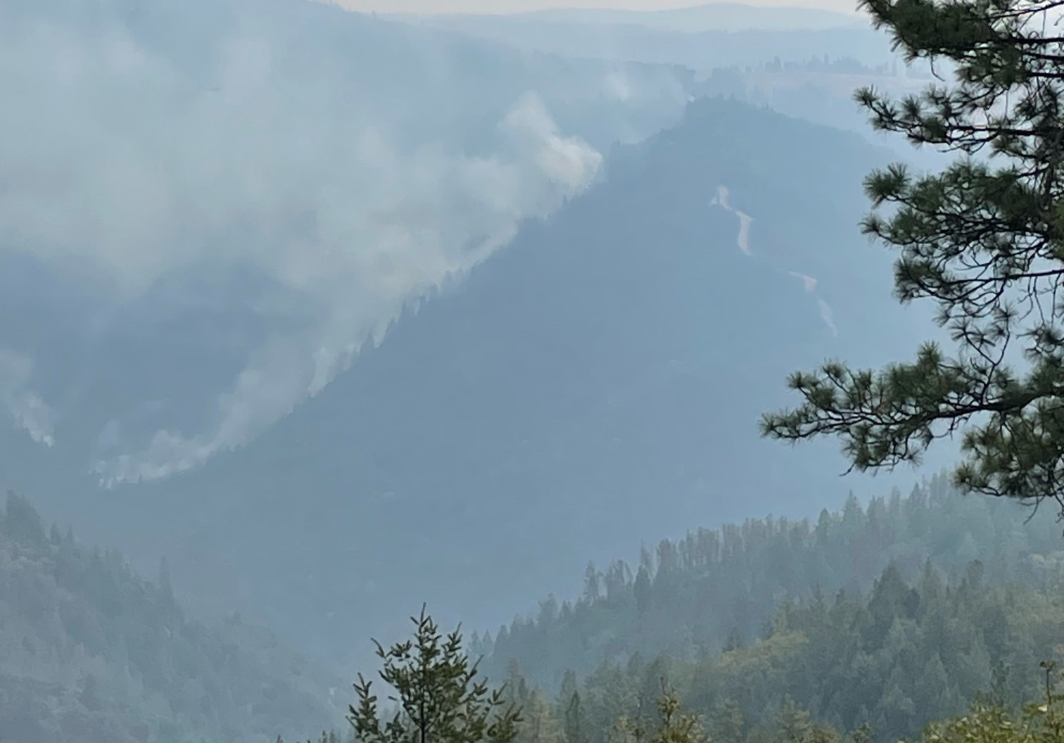
Large dozer line, seen from Worton’s in Foresthill, all the way down to the river.
Two helicopters are working on the south side of the Middle Fork, one is working near Mosquito Ridge Road below Foresthill, all supporting the firefighters on the ground.
September 11, 2022 at 1:03 PM
Helco is over the incident, reporting decent visibility in the Foresthill area.
Starting to order some air support. Meanwhile, ground resources have continued to build direct and indirect lines, prepare areas for strategic firing operations, patrol near structures and infrastructure.

September 11, 2022 at 9:53 AM
Mobile retardant plants, fresh off the Weed Fire, have arrived on the incident.


September 11, 2022 at 8:30 AM
The message from the Incident Commander to the fire fighters this morning included this: “Thank you for the good work that’s going on out there. We’re able to get some black on the map and show some containment this morning and that’s going to go a long way in this community to bring some relief and that’s all reflection of the work you guys are doing out there. So thank you for those efforts. There’s still a lot of work left out there, so keep your heads up as we move forward, but we’re making progress. The community is going to appreciate that.”
September 11, 2022 at 7:48 AM
Some highlights from the ops briefing:
Night operations highlights: For Foresthill, they were able to get the fire all the way down to the American River last night. There’s a ton of work still to be done, but a good successful night on that Baltimore Mine Road coming across over to Buckeye. They kept up with the fire last night. The line is mostly all the way in, if not all the way in by this morning. As you come around through Volcanoville down into Quintette, that’s all looking good.
Day operations: Some special missions out in Division Juliet by the Big Trees. Lots of indirect line construction and prep work for potential firing operations. Mop up and holding the established lines.
Air operations: Seven Type 1, three Type 2 and two Type Helicopters. Helco and Air Attack full coverage for the day. A nighttime Helco for any intel gathering if that’s needed. Two Super Scoopers that came in yesterday, they are going to be based out of South Lake Tahoe and dipping in the reservoirs just on the east side of the fire support.
September 11, 2022 at 7:39 AM
Video of the operations briefing for today’s day shift.
September 11, 2022 at 7:17 AM
No big weather changes are forecast for Sunday. Smoke and clouds will expected to shade the fire, resulting in somewhat reduced fire behavior. High temperatures will be generally in the 80s and minimum humidity 25-30%. Winds will generally be southwest 5-10 mph.

September 11, 2022 at 7:11 AM
Fire behavior Saturday was moderate, consisting of isolated torching, uphill runs, and short-range spotting. When air cleared, the fire exhibited isolated torching and slope runs, especially on the southwest side near Georgetown. Elsewhere around the perimeter, fire behavior was reduced under the smoke inversion. Critically dry vegetation is readily igniting and burning despite the improved weather. When rollouts occurred, the fire made upslope runs.
Saturday night, fire behavior moderated as humidity increased.
September 10, 2022 at 10:36 PM
Official evening update: Cooler temperatures and higher humidity assisted with moderating some fire activity on the Mosquito Fire today, however an increase in winds has continued the fire’s spread to the north and northeast. Firefighters have been working diligently to build control lines along the area of Foresthill Road and out in front of the head of the fire toward the north and northeast. A spot fire in the area of Chicken Hawk occurred yesterday and firefighters were able to contain that fire with the help of dozers and aircraft today.
Crews are opening up previously used control lines from past fires to assist in their efforts. Firefighters have been making good progress on the southern edge of the fire using dozer and handlines. A large amount of resources have been working to hold the fire at Volcano Road as well as north of Quintette.
With the increase in fire activity to the east of the communities of Foresthill, several more Evacuation Orders and Warnings have been issued. More resources from throughout California continue to arrive to assist in the suppression efforts. Both fixed-wing and rotor-wing aircraft continue to assist ground crews as flying conditions allow.
September 10, 2022 at 9:59 PM Backing fire seen from Foresthill looking to the southeast.

September 10, 2022 at 7:30 PM
Some key points from the briefing:

Point of origin for the fire, started off down here in Oxbow. It’s currently under investigation. The start of the fire happened on September 7. The fire grew pretty rapidly into what it currently is now. Most of the fire’s edge is currently pretty active here. All the fire’s edge up here along the east side of the community of Foresthill remains pretty active as you kind of continue north around the northern part of the community here.
Crews are going direct with hand crews, dozers and engines to pick up the fire’s edge direct as much as possible where the terrain will allow them to do so. If they continue north they’re going to take an indirect action there just because of the terrain features.
They will have contingency lines that come out to the north here heading northbound, that will connect along Chicken Hawk Road heading northbound. The fire still remains pretty active here on the north end of the fire.
We did get some reprieve with some of the weather that we’ve had, but the fuels conditions are still pretty volatile at this time. As we continue north here, the fire east of Chicken Hawk Road remains very active. Crews are working that edge now going north to stay out in front of the main fire there, putting in indirect line as they continue north there.
As you move further out towards the northeast end of the fire here, the fire still remains fairly active. It’s a more remote area of the fire here. We do have crews and resources looking at indirect mines that will be coming across the 13 road down out towards the Mosquito Ridge Road. From there they’re going to continue to work out towards the east here, working their way out indirect out in front of the main fire here.
All these fires edges continues to remain pretty active and they’ll be working out here out in front of the main fire trying to put in indirect line as you move out here towards the east/southeast end of the fire. Very active fire front. As you come down through the southeast side of the fire, crews are working to come up indirect out of the Stumpy Meadows Reservoir coming up towards the northeast connecting existing fuel brakes that currently exist in this general area up towards the north to connect it from the crews coming down from the northern end.
As you come around the bottom end of the fire here we have some indirect lines that are proposed coming out of Pilot Creek. As we come out of Pilot Creek we’ll look at trying to come back around the southeast into the fire, back over towards the Wentworth Springs Road coming up through the network of roads where the fire is currently holding with a direct hand line and dozer line along the south end of the fire here.
As the fire got up and approached Volcano Road the crews were able to take aggressive action to stop the fire along Volcano Road. Currently it’s holding. They’ve been able to come out towards the west along the Volcano Road and they’re looking at coming off towards Buckeye Point back into the American River. They’re making good progress. They still have quite a fight on their hands but they’re making good progress coming out towards here and the fire activity will dictate how they continue to move forward.
Dozer lines on the north side of the community of Quintette. This piece right here has a lot of firefighters in here trying to pick this fire up direct as possible to keep it from continuing south into the community of Quintette. We’re going to continue to maintain a heavy presence down here until we can show containment and continue to mop up and secure this edge to where it’s safe to eventually repopulate that area and allow all of you to return to your residence.
September 10, 2022 at 7:03 PM
September 10, 2022 at 6:38 PM
New evacuation orders issued for Placer Zone 21 (South of the North Fork of the American River down to Elliott Ranch Rd and Foresthill Rd to Westville Rd, Independence Hill Rd, Bird Flat Rd, Pioneer Mine Rd, China Wall OHV Staging Area) and 22 (South of the North Fork of the American River, north of the Middle Fork of the Rubicon River, west of French Meadows Reservoir and west of Sailors Canyon-Chipmunk Ridge)
New evacuation warnings issued for Placer Zones 23 (West edge of French Meadows Reservoir east to the east edge of Hell Hole Reservoir, south of the North Fork of the American River to the Rubicon River) and 25 (West edge of French Meadows Reservoir east to the east edge of Hell Hole Reservoir, south of the North Fork of the American River to the Rubicon River)
September 10, 2022 at 6:25 PM
Numerous structures of all types are located within the fire vicinity. A Damage Inspection Team is evaluating damaged properties. Currently 997 PG&E customers are without power. 11,260 people are evacuated. 1,792 firefighters assigned. Increase in acreage is mostly due to strategic firing operations.
September 10, 2022 at 5:20 PM
Mosquito Fire Virtual Community Meeting
WHEN: September 10, 2022, at 7:00 p.m.
WHERE: On YouTube and Facebook Live via Unified Command Agencies – see links below.
WHO: Join Mosquito Fire Unified Commanders and other representatives from:
CAL FIRE Nevada – Yuba – Placer Unit, U.S. Forest Service Tahoe National Forest, U.S. Forest Service El Dorado National Forest, the Placer County Sheriff’s Office, and El Dorado County Sheriff’s Office.
They will discuss the firefighting efforts and progress on the Mosquito Fire, as well as impacts on the various communities such as evacuations for those who have been affected. The meeting will appear on Facebook at CAL FIRE Nevada – Yuba – Placer Unit and U.S. Forest Service El Dorado National Forest page shortly before the meeting begins.
Additionally, we request community members submit questions in advance via Facebook Messenger to the agencies that will be participating to provide as much information as possible during this thirty (30) minute live stream. Additional questions may be answered in the comments sections of the meeting after the virtual town hall is complete. Visit the live stream of your choice on Facebook at 7:00 p.m. at one of the listed links below.
CAL FIRE Nevada – Yuba – Placer Unit: https://www.facebook.com/CALFIRENEU/
U. S. Forest Service – El Dorado National Forest: https://www.facebook.com/eldoradonf
If you prefer to participate via YouTube , please visit the live stream at: www.tinyurl.com/mosquitofire.
September 10, 2022 at 4:09 PM
For those with limited internet access, the descriptions and boundaries of the evacuation zones are taken directly from the interactive evacuation map that the El Dorado County Sheriff’s Office manages and updates.
Evacuation Orders are in effect for the following areas:
- Area Name: Volcanoville
- North of Wentworth Springs, east of Otter Creek, south of the county line, and west of Tunnel Hill Road
- Area Name: Quintette
- North of Wentworth Springs, east of Lofty Peak Lane, south of county line, and west of Blackeye Pea Road
- Area Name: Bald Mountain
- East of Breedlove Road (including both sides of Wentworth Springs Road) and West of Stumpy Meadows Lake
- Area Name: Grey Eagle
- East of Breedlove Road (including both sides of Wentworth Springs Road) and west of Stumpy Meadows Lake
- Area Name: Canyon Creek
- East of Greenwood Road, south of the county line, and north of Meadow Brooke Road
- Area Name: Georgetown
Evacuation Warnings are in effect for the following areas:
- Area Name: Cool
- Area Name: Garden Valley
- Area Name: Swansboro / Slate Mountain
- Area Name: East Stumpy Meadows
September 10, 2022 at 3:42 PM
Spotted at Wortens in Foresthill, members of the Wildfire Interdisciplinary Research Center at San Jose State University. Their trucks are equipped with Doppler lidar and radar, and an array of other laboratory facilities, sensor systems, and field equipment. Learn more about the program.


September 10, 2022 at 3:35 PM
Radio traffic reports show good progress on contingency and direct lines. Multiple helicopters work ahead of the ground resources to cool down areas. VLATs painted the west side between Quintette and Stumpy Meadows to slow progression of the fire. Lots of resources in that area and in Division H, the Deadwood Ridge area in the east.
September 10, 2022 at 2:38 PM
Yesterday resources were able to construct dozer and handline on the north side of Quintette to the community. Resources have been making progress building containment line on the northwest side of the fire. Last night fire growth was predominantly moving in a southeast and northeast direction.
Today with the onset of the low-pressure system, higher winds will move in which will fan the fire and increase activity. Fire crews will work to construct direct and indirect line around the perimeter of the fire. Additional resources will be working on perimeter control and preparing structures for defensive actions.
Both the El Dorado County Sheriff’s Office as well as the Placer County Sheriff’s Office are constantly monitoring and evaluating evacuated areas assessing the need for additional evacuations and when it is safe to repopulate.
September 10, 2022 at 12:59 PM
Fire activity is picking up, isolated torching and short runs reported by Air Attack.
September 10, 2022 at 12:57 PM
Two additional Type 1 helicopters for division D ordered.
September 10, 2022 at 12:48 PM

Dozer lines off Alton Trail in Todd Valley looking good.
September 10, 2022 at 12:27 PM
VLATs will be working the south side of the fire near Stumpy Meadows Reservoir, per Air Attack.
September 10, 2022 at 12:21 PM
Planned actions today:
- Provide structure defense and point protection for values at risk.
- Protect private timberlands.
- Scout for opportunities to construct containment lines.
- Perform firing operations where appropriate.
- Construct direct and indirect line as conditions and opportunities allow.
September 10, 2022 at 12:01 PM
Two small spot fires on the east side of the fire in Division Hotel. Also some open flame in Division GG. Helicopters are being assigned to both divisions. (map of the divisions is a little further down this page.)
September 10, 2022 at 11:48 AM
Air Attack is over the fire, with several helicopters working between Quintette and Stumpy Meadows.
September 10, 2022 at 9:44 AM
A look at some of the firefighters getting ready for the morning shift. Photos by Gene Lorance.


September 10, 2022 at 9:33 AM
An emergency shelter for Mosquito Fire evacuees opens at 10 a.m. today at Sierra College in Rocklin, and the former shelter site at the Bell Road Baptist Church in Auburn has closed. More information here.
Residents under mandatory evacuation due to the Mosquito Fire can access the shelter, operated by the American Red Cross, at:
Sierra College
5100 Sierra College Blvd, Rocklin (enter on Rocklin Road)
Parking will be in Lot B
Shelter will be in the cafeteria (building J)
The RV/Trailer Temporary Evacuation Point Parking at the Auburn Regional Park Gym (3770 Richardson Drive, Auburn) also remains operational for parking, bathrooms and shower access only (no hookups or sleeping spaces).
Additional community resources can be accessed by calling 211 (or 1-833-342-5211 for Placer residents outside of the county). For those looking to help, donation information is available on the Ready Placer dashboard.
September 10, 2022 at 8:38 AM

For those with limited internet access, the Placer County evacuation orders and warnings are listed below. The descriptions and boundaries of the evacuation zones are taken directly from the interactive map that the Placer County Sheriff’s Office manages and updates.
Evacuation Orders are in effect for the following zones:
- Zone 1:
- Michigan Bluff Road
Gorman Ranch Road
Chicken Hawk Road
Ridge View Road
Deadwood Road
- Michigan Bluff Road
- Zone 2:
- Baker Ranch Mobile Home Park
- Zone 3:
- Crystal View Road
Bath Road
- Crystal View Road
- Zone 4:
- Foresthill Road from Idlewild Road to Bath Road
Powerline Road
Timberland Road
Sluice Box Lane
- Foresthill Road from Idlewild Road to Bath Road
- Zone 5:
- Black Oak Ridge Road
Blackhawk Lane
Ebbert Ranch Road
Old Ebberts Ranch Road
- Black Oak Ridge Road
- Zone 6:
- Finning Mill Road to Sugar Pine Road to Elliot Ranch Road to Foresthill Road
Big Reservoir Road
Giant Gap Road
Hollow Log Road
Prospect Road, NF-10
- Finning Mill Road to Sugar Pine Road to Elliot Ranch Road to Foresthill Road
- Zone 7:
- South of Foresthill Road
North of the Middle Fork of the American River
West of Jarvis to include Patent
East of McKeon Ponderosa to the American River
- South of Foresthill Road
- Zone 8:
- Sky View Mobile Home Park
- Zone 9:
• Spring Garden Road at Foresthill Road to Yankee Jims Road
• Foresthill Road at Spring Valley Road to Idlewild Road
• Hosmer Mine Court
• Gray Eagle Lane
• Indian Lane
• Little Oak Lane
• Melody Lane - Zone 10:
• Ponderosa Way at Foresthill Road to the North Fork of the American River to Yankee Jims Road to Spring Garden Road
• Pine Mountain Road
• Morning Star Place
• Eaglecrest Drive - Zone 12:
• Foresthill Road from Foresthill Bridge to Drivers Flat
• Old Foresthill Road/Old Auburn Foresthill Road from Hwy 49 to Foresthill Road
• All roads off Foresthill Road within this stretch - Zone 14:
Blacksmith Fit Road to French Meadows Road
South to the American River
North to Mosquito Ridge Road
Evacuation Warnings are in effect for the following zones:
- Zone 11A:
- Yankee Jims Road to the American River to Kings Hill Road to Big Dipper Road to Iowa Hill Road south to Yankee Jims Road
- Zone 15:
- Foresthill Road at Drivers Flat Road to Ponderosa Road
- All side roads along this stretch
September 10, 2022 at 8:29 AM
September 10, 2022 at 8:12 AM
The fire has been burning actively overnight. Higher relative humidity Saturday may provide a slight and temporary decrease in fire behavior, but expect very active fire growth overnight.
September 10, 2022 at 8:08 AM
143 out of 11,117 evacuees are in shelters. To date, one firefighter injury and no civilian injuries reported.
September 10, 2022 at 7:45 AM
Dozer and hand lines in Division D, C and KK. Image below links to the original pdf file (14MB)

September 10, 2022 at 7:33 AM Weather outlook: On Saturday, critically hot, dry conditions will moderate slightly with the moisture effects from Hurricane Kay. Relative humidity will be slightly higher and temperatures slightly cooler (into the 90s). No major wind events are anticipated, and diurnal wind patterns will preside. Considerable fire growth and smoke plume development are possible. Winds aloft will shift east to southwest to west to southeast with the passage of the remnants of Hurricane Kay.
September 10, 2022 at 7:10 AM Photos by Gene Lorance from Foresthill Road down 1.9 miles on Mosquito Ridge Road.


September 10, 2022 at 6:48 AM
FIRIS perimeter at 33,842 acres, hazardous air quality in Placer and Nevada counties.
September 9, 2022 at 10:11 PM
Smoke forecast for the weekend.
This is an experimental smoke forecast model and may not be available at all times. It is also NOT an official air quality forecast. The official Air Quality forecast for California can be found here: AirNow (fire.airnow.gov)
September 9, 2022 at 7:03 PM
El Dorado Sheriff’s community meeting is not livestreamed due to technical difficulties. They are recording and will post it after the meeting concludes.
September 9, 2022 at 6:22 PM
Numerous structures of all types are located within the fire vicinity. A Damage Inspection Team has begun evaluating damaged properties today.
Currently 997 PG&E customers are without power.
11,260 people evacuated, 4,782 homes, 20 multiple residences, 46 commercial properties and 1,000 minor structures remain threatened.
Communities at Risk: Foresthill, Baker Ranch, Todd Valley, Georgetown, Michigan Bluff, Chickenhawk Ridge, Volcanoville, Quintet, Todd Valley, and surrounding isolated residences all remain threatened.
Impact to communities: Foresthill Union School District & Black Oak Mine Unified School District closure affecting all the students and employees. Smoke is impacting all the way to Susanville in the North, to Eureka, Nevada in the East, to Lodi & Jackson in the South & Northern Bay Area in the West.
Critical Infrastructure Threat: PG&E Transmission Middle Fork-Gold Hill-230kV and structures, PG&E Transmission Middle Fork #1 60 kV and structures, PG&E Distribution Foresthill 1101 and structures, PG&E Weimar #1-60kV and structures, PG&E Distribution Placerville 2106 and structures, PG&E Distribution Mountain Quarries 2101 and structures, PG&E Asset Roads, microwave transmission tower, cell towers, radio repeaters, Forest Service Seed Orchard, Placer County Big Trees Grove of Giant Sequoias.
Historical and Cultural Resources: Threat to significant cultural and heritage sites. Historic Western Estates Trail, Historic Town of Deadwood.
Watersheds: North Fork American River & South Fork American River
Airshed: Placer County APCD & El Dorado County AQMD
T&E Species habitat: Nesting and foraging habitat for Bald Eagle, bank swallow, willow flycatcher, wolverine, Sierra Nevada yellow-legged frog, California red-legged frog & Layne’s ragwort plant.
Commercial resources: significant impact and closures of various recreational areas: Foresthill Divide Loop Mountain bike and hiking trails within the Auburn State Recreation Area (ASRA), various reservoir closures – Oxbow, Sugar Pine, Big Reservoir, French Meadows, Hell Hole Reservoirs & Lake Clementine – which impacts all the associated campsites, fishing and associated recreation, impact to vineyards, commercial timberlands, Sierra Pacific Industries timberlands, various small industrial tree farmers with Christmas tree farms, various wedding venues – Forest House Lodge and Monte Verde Inn, and UC Berkeley’s Blodgett Experimental Forest.
September 9, 2022 at 5:31 PM
OES Intel 12, Sept 9th on the Mosquito Fire, TNF. Second video of the mission. Fire is mapped at 29,585 acres at 12:16 hours.
September 9, 2022 at 4:20 PM
Update from Adam Coyan General Manager GDPUD (Georgetown Divide) on their water system. The system is fully operational and maintenance staff is on site, making sure the ditches are clear. Coyan stated that water utilization right now, with evacuations in effect, is actually higher than normal. Sprinklers around homes and more intensive irrigation to protect properties are the likely cause. Water conservation right now would be more appropriate, given the size and intensity of the fire. He also gave a shout-out to EID who offered any repair materials needed the district might not have readily on hand. To sum up, the Georgetown water system is fully functional.
We will remove the 3:11 pm update since we have been unable to confirm the radio traffic.
September 9, 2022 at 4:01 PM
Placer County Health and Human Services and the Placer County Air Pollution Control District have extended the joint air quality advisory through Monday, September 12, 2022, to notify the public of the potential for poor air quality conditions from smoke from the Mosquito Fire in both Placer and El Dorado counties.
September 9, 2022 at 2:51 PM
Smoke inversion is starting to lift over the fire, operations are assigning helicopters to support the ground resources’ efforts.
September 9, 2022 at 2:32 PM
El Dorado County: Mosquito Fire Town Hall Meeting
Tonight at 6:30 pm
In attendance:
El Dorado County Sheriff John D’Agostini
US Forest Service
Cal Fire
Supervisor Parlin
Sutter’s Mill School
Inside of the multipurpose room
4801 Luneman Road, Placerville, CA
This meeting will also be live streamed on Facebook https://www.facebook.com/eldoradosheriff
September 9, 2022 at 2:09 PM
Fire has impacted the Circle Bridge on Mosquito Ridge Road, per radio traffic it is impassible now.
September 9, 2022 at 1:20 PM
September 9, 2022 at 11:54 AM
Per El Dorado County Sheriff: The Temporary Evacuation Point at the Cool Community Church for triaging Mosquito Fire evacuees is closed because it’s in the evacuation warning zone. Evacuee shelter is located at the Cameron Park CSD at 2502 Country Club Dr., Cameron Park.
September 9, 2022 at 11:09 AM
There is no defined column on the fire with the heavy inversion.
Per Caltrans: SR-193 has been closed from 5.7 miles east of the Placer/El Dorado County line at Pilgrim Road to Black Oak Mine Road due to the fire. ETO is unknown at this time. Please avoid the area if possible to allow emergency crews access.
September 9, 2022 at 10:50 AM
New FIRIS perimeter show 29,585 acres, with growth in the Quintette area.
September 9, 2022 at 10:35 AM
No aircraft on the fire except the mapping flight, due to the heavy smoke over the fire. There is some spread towards Quintette, ground resources are prepping structures in the area.
September 9, 2022 at 9:56 AM “At least 23,000 acres.”
https://twitter.com/PlacerSheriff/status/1568281908009910276
September 9, 2022 at 9:54 AM
FIRIS mapping plane over the fire again.
September 9, 2022 at 9:47 AM
California has secured a Fire Management Assistance Grant (FMAG) from the Federal Emergency Management Agency to help ensure the availability of vital resources to suppress the Mosquito Fire burning in El Dorado and Placer counties.
September 9, 2022 at 9:13 AM
Unified Commanders are aware of structure damage in the Michigan Bluff area. Where safe, damage inspection teams will begin assessing areas within the fire area today, and additional information will be provided when it is available.
Also, the current acreage is being verified and could be subject to change. Expect an update within the hour.
September 9, 2022 at 9:06 AM
Spot fire half a mile up from Wentworth reported by firefighters.
September 9, 2022 at 8:41 AM
Hazards include extreme heat, rapid fire growth, limited access, and steep terrain.
Numerous structures of all types are located within the fire vicinity. Property damage will be assessed as resources arrive and opportunity allows.
Mandatory Evacuations:
Michigan Bluff: Michigan Bluff Rd, Gorman Ranch Rd, Chicken Hawk Rd, Ridge View Rd, Deadwood Rd
Finning Mill Rd to Sugar Pine Rd to Elliot Ranch Rd to Foresthill Rd, Big Reservoir Rd, Giant Gap Rd, Hollow Log Rd, Prospect Rd, NF-10
Blacksmith Fit Rd to French Meadows Rd, South to the American River, north to Mosquito Ridge Rd
Black Oak Ridge Rd, Blackhawk Ln, Ebbert Ranch Rd, Old Ebberts Ranch Rd
Spring Garden Rd at Foresthill Rd to Yankee Jims Rd, Foresthill Rd at Spring Valley Rd to Idlewild Rd , Hosmer Mine Ct, Gray Eagle Ln, Indian Ln, Little Oak Ln, Melody Ln
Todd Valley: South of Foresthill Rd, of the Middle Fork of the American River, west of Jarvis to include Patent, east of McKeon-Ponderosa to the American River
Evacuation Warning:
Yankee Jims Rd to the American River to Kings Hill Rd to Big Dipper Rd to Iowa Hill Rd south to Yankee Jims Rd
Foresthill Rd at Drivers Flat Rd to Ponderosa Rd, all side roads along this stretch
September 9, 2022 at 8:36 AM
Per El Dorado County the Rubicon Trail is closed until further notice due to all emergency personnel responding to the Mosquito Fire.
September 9, 2022 at 7:10 AM
Some early morning photos by Gene Lorance from Foresthill, “at this time everything in town is good.”


September 9, 2022 at 6:33 AM
There were no additional evacuations overnight. Heavy smoke layer over the fire which should moderate fire behavior somewhat. For those asking why there is no containment on this fire yet: First responders are focusing on safely evacuating people and defending homes and infrastructure. Be safe everyone.
September 8, 2022 at 11:38 PM
Latest FIRIS mapping puts the acreage at 25,108.
September 8, 2022 at 11:19 PM
EVACUATION ORDERS are in effect for the following communities in Placer County:
Zone 1 – Michigan Bluff
• Michigan Bluff Rd
• Gorman Ranch Rd
• Chicken Hawk Rd
• Ridge View Rd
• Deadwood Rd
Zone 2 – Baker Ranch
• Mobile Home Park
Zone 3 – Crystal View Rd and Bath Rd
Zone 4 – Foresthill
• Foresthill Rd from Idlewild Rd to Bath Rd
• Powerline Rd
• Timberland Rd
• Sluce Box Ln
Zone 5
• Black Oak Ridge Rd
• Blackhawk Ln
• Ebbert Ranch Rd
• Old Ebberts Ranch Rd
Zone 6
• Finning Mill Rd to Sugar Pine Rd to Elliot Ranch Rd to Forestill Rd
• Big Reservoir Rd
• Giant Gap Rd
• Hollow Log Rd
• Prospect Rd, NF-10
Zone 7 – Todd Valley
• South of Foresthill Road
• North of the middle fork of the American River
• West of Jarvis to include Patent
• East of McKeon Ponderosa to the American River
September 8, 2022 at 10:31 PM
MOSQUITO FIRE EL DORADO COUNTY EVACUATION UPDATES
There is an EVACUATION WARNING in the in the area of Stumpy Meadows.
- East of Stumpy Meadows
- West of Loon Lake
- South of the County border
- North of Little Silver Creek
There is an EVACUATION WARNING in the area of Slate Mountain, including Swansboro.
- East of Garden Valley
- South of Sand Mountain
- North of the Mosquito Bridge
- West of Traverse Creek
There is an EVACUATION WARNING in the area of Cool.
- East of Highway 49
- South of the County Line
- North of Highway 49/Coloma Road
- West of Greenwood Road
El Dorado County has opened an overnight shelter for Mosquito Fire evacuees at Cameron Park Services District, 2502 Country Club Drive, Cameron Park, CA 95682. Overnight shelter, meals, showers, limited health services, and parking for trailers will be provided. Animals in crates and carriers will be accepted.
Please be prepared to evacuate IF the Evacuation Warning becomes an Evacuation Order. Those who require additional time to evacuate, including those with pets and livestock, should consider leaving now.
Today’s operational period saw the continued extreme growth of the Mosquito Fire, as it has now burned 13,704 acres and progressed into El Dorado County. Fire activity has included crown runs and spotting which is expected to occur throughout tonight. The winds and steep terrain have been in alignment which have combined to create the conditions conducive to the observed fire conditions.
This caused new evacuation orders to be issued by the El Dorado County Sheriff’s Office for the communities of Volcanoville, Georgetown, and Bottle Hill while Cool is under and evacuation warning. Additionally the Placer County Sheriff’s Office expanded its evacuation orders into Todd Valley.
The priority for firefighting personnel is the life safety of the community and structure protection. Additionally, the construction of direct and indirect containment lines utilizing handcrews and bulldozers is a significant objective. As the incident evolves, reconciliation of resources and the number of community members affected will continue to be updated
The Unified Commanders of the Mosquito Fire thank the community for their support and cooperation in adhering to evacuation orders and warnings, and remind those who are in an area when an evacuation order is implemented that it is time to leave. The decision to evacuate a community is done with the understanding of the inconvenience it places on those who live and work in a community, but also with the priority of life safety.
September 8, 2022 at 8:48 PM
Structure threat and imminent spotting potential on Mosquito Ridge Road.
September 8, 2022 at 8:46 PM
Earlier today in Foresthill and right now. Photos Erik Vandagriff.


September 8, 2022 at 7:13 PM
3,600 residences threatened. Property damage is unable to be determined due to rapid fire growth and limited on scene resources.
The communities of Forest Hill, Baker Ranch, Georgetown, Michigan Bluffs, Chickenhawk Ridge, Volcanoville, Quintet, Todd Valley, and surrounding isolated residences remain threatened. Additionally, Oxbow reservoir power plant, PG&E 260 and 230KV transmission lines, microwave transmission tower, cell towers, radio repeaters, Forest Service Seed Orchard, Big Trees Old growth, critical watershed, multiple Sierra Pacific Industries tree groves are threatened.
September 8, 2022 at 7:04 PM
September 8, 2022 at 7:01 PM
Placer County: In addition to the emergency shelter at Bell Road Baptist Church, we have also opened a temporary evacuation point for RV/trailer/car parking where evacuees will have bathroom and shower access. (No hookups, sleeping spaces, etc.) Additional sheltering space is under development; stay tuned to our incident page: www.placer.ca.gov/current-incidents
RV/Trailer Temporary evacuation point
Parking (for RV/Car), bathrooms and shower access ONLY (no hookups/sleeping spaces/etc.)
Auburn Regional Park Gym
3770 Richardson Dr, Auburn, CA 95602
*Additional sheltering space under development
September 8, 2022 at 6:18 PM
Dozer operations in the town of Foresthill, creating a fire break along Foresthill Road from Dollar General. Photos by Gene Lorance.


September 8, 2022 at 6:10 PM Again a no divert on the tankers due to imminent life safety threat. Downslope of Foresthill is the focus.
September 8, 2022 at 5:43 PM
Governor has proclaimed a state of emergency for El Dorado and Placer counties due to the Mosquito Fire.
September 8, 2022 at 5:35 PM
El Dorado County has opened an overnight shelter for Mosquito Fire evacuees at the Cameron Park CSD, 2502 Country Club Drive. Overnight shelter, meals, showers & limited health services available. Animals in crates/carriers are accepted & there is parking available for trailers.
September 8, 2022 at 5:29 PM
September 8, 2022 at 5:10 PM
13,705 acres according to the latest FIRIS mapping.
September 8, 2022 at 5:01 PM
FIRIS is over the fire again, mapping update when they sent the data.
September 8, 2022 at 4:54 PM
10 minutes ago behind the old Elementary School photo taken at the base camp by Gene Lorance. UPDATE: That photo was from the staging area looking through the Dollar General.

September 8, 2022 at 4:48 PM
Air Attack concerned about the area of Pine Street in Foresthill, due to spotting.
September 8, 2022 at 4:42 PM
Air Attack reports a few spots over the highway (Old Foresthill Road), there is an engine on scene that will take action immediately.
September 8, 2022 at 4:39 PM
Air Attack going to take a look under the column to see if the fire has jumped the road.
September 8, 2022 at 4:38 PM
Placer County Animal Services Center in Auburn suspended new animal intakes after reaching capacity. If you are in a mandatory evacuation area and do not have such resources, large and small animals can be taken to:
Nevada County Fairgrounds
11228 McCourtney Rd, Grass Valley
Enter through gate 8 for check in; drop-off only (no camping) *No chickens/poultry due to avian flu.
September 8, 2022 at 4:35 PM
Tanker drop at the head of the fire, from PCWA’s Foresthill camera.

September 8, 2022 at 4:02 PM
No divert for the tankers stands, still life safety threat, including structures.
September 8, 2022 at 3:54 PM
The El Dorado Sheriff’s Office has implemented evacuation orders for several El Dorado County communities as described in the attachment below:
Due to rapidly changing fire conditions and the spread of the Mosquito Fire across the American River into El Dorado County, the El Dorado County Sheriff’s Office has ordered an immediate evacuation of the following communities:
Volcanoville:
• North of Wentworth Springs
• East of Otter Creek
• South of the Placer County Line
• East of Tunnel Hill Road
Bottle Hill – Please evacuate the area using Westbound Wentworth Springs towards Georgetown:
• East of Breedlove Road including both sides of Wentworth Springs Road
• Breedlove Road West of Stumpy Meadows Lake
Georgetown:
• East of Greenwood Road
• South of the County Line and North of Meadow Brooke Road
TEMPORARY EVACUATION POINT
A Temporary Evacuation Point has reopened at Cool Community Church at 863 Cave Valley Rd., Cool, CA 95614 as a place for those impacted by the #MosquitoFire to gather to determine their next steps. This location will accommodate evacuees and their domestic animals except for birds (due to a potential for Avian Flu), temporarily, until more permanent evacuation centers become available.
September 8, 2022 at 3:50 PM
Grass Valley ECC: one strike team, immediate need to the Mosquito Fire from NEU
September 8, 2022 at 3:41 PM
PCSO only responding to priority calls, they are running out of resources. “Ask Lincoln, Rocklin, Roseville for help if need.” per radio traffic.
September 8, 2022 at 3:36 PM
Road closures per PCSO map:
Foresthill at Upper Todd Valley: EB Foresthill Rd is closed at Upper Todd Valley Rd.
Yankee Jims at Spring Garden: EB Yankee Jims Rd is closed at Spring Garden Rd
September 8, 2022 at 3:29 PM
Per Foresthill Fire Dept. on FB: Mandatory Evacuation for Todd Valley and roads off of Foresthill Road. We are working with the county sheriff to get a better description of the new evacuation area since the zone system is not clear.

September 8, 2022 at 3:26 PM
No divert again on four tankers for life safety threat.
September 8, 2022 at 3:16 PM
Twenty engines, immediate need to the fire. The Todd Valley area between Foresthill and Auburn will be under mandatory evacuation now – was in an evacuation warning.
September 8, 2022 at 3:12 PM
Old Foresthill Road is being shut down at Hwy 49.
September 8, 2022 at 3:02 PM
The Georgetown and Greenwood areas are under an Evacuation Warning. If you need extra time, leave now.
September 8, 2022 at 2:55 PM
September 8, 2022 at 2:47 PM
Per Air Attack, the fire has impacted Volcanoville, multiple structures lost. It is starting to burn towards Foresthill. Potential of the fire making a run up to Old Mill Road.
September 8, 2022 at 2:46 PM
Per El Dorado County Sheriff: A Temporary Evacuation Point has reopened at Cool Community Church at 863 Cave Valley Rd, Cool, CA 95614 as a place for those impacted by the #mosquitofire to gather to determine their next steps. This location will accommodate evacuees and their domestic animals except for birds (due to a potential for avian flu). Donations are not being accepted at this location; please contact Red Cross if you are interested in donating.
September 8, 2022 at 2:39 PM
Several large tankers over the fire now. Law enforcement and firefighters are assisting with evacuations. Please, do not wait to leave when asked to.
September 8, 2022 at 2:22 PM
Fire is was less than 2,000 ft. from Volcanoville Road one hour ago.
September 8, 2022 at 2:14 PM
Expanded Evacuation Orders in El Dorado County. From Buckeye and Quintette to Fairbanks and up to Stumpy Meadows.
September 8, 2022 at 2:02 PM
Air Attack requesting 3 multi-engine tankers, immediate need.

September 8, 2022 at 2:00 PM
Seen from the Foresthill side as the fire jumped the American River. Photo courtesy Gene Lorance.

September 8, 2022 at 1:39 PM
Placer County has proclaimed a local emergency due to the ongoing threat from the Mosquito Fire.
September 8, 2022 at 1:34 PM
New acreage after FIRIS mapping is 8,625.
September 8, 2022 at 1:28 PM
AA 230 and AA 505 are over the El Dorado side of the fire. Requesting a no divert on the four tankers to continue.

September 8, 2022 at 1:07 PM
Air Attack reports the fire has jumped the American River on the El Dorado side, requesting VLATs to come back due to multiple structures threatened. No divert on the 4 tankers currently assigned. Structures on the ridgeline are imminently threatened, also threat to Foresthill.
September 8, 2022 at 12:51 PM FIRIS mapping plane is over the fire again, expect an updated acreage and perimeter soon. Large and Very Large Air Tankers over the fire.
September 8, 2022 at 11:58 AM
Air Attack is releasing Tanker 89 back to Grass Valley. There are numerous helicopters working the fire and Tanker 86 is inbound.
September 8, 2022 at 11:49 AM
September 8, 2022 at 11:19 AM
PG&E has submitted an Electrical Incident Report re the Mosquito Fire to the California Public Utilities Commission (CPUC) indicating caution tape has been placed around the base of a 60Kv transmission by the U.S. Forest Service.
September 8, 2022 at 10:28 AM
The Mosquito Fire has demonstrated critical fire behavior since it ignited on September 6, 2022 at 6:22 P.M. This led to the implementation of several evacuation orders and warnings throughout the fire area. Additionally, some structures have been destroyed and damaged within the fire perimeter.
In those areas where it has been deemed safe, CAL FIRE Damage Inspectors have started to assess the structural damage. This information will be made available as it is collected to those who have been affected.
This is a rapidly evolving fire incident with dynamic fire behavior. Life safety of our community and firefighters, combined with the protection of property and the environment is the primary goal of the Mosquito Fire Unified Commanders.
September 8, 2022 at 9:30 AM
Structure protection in the Foresthill and Michigan Bluff is a high priority. Crews using clearing vegetation, hand and dozer lines and backfires to save homes. 1,700 firefighters assigned today.

September 8, 2022 at 9:16 AM
Here’s today’s morning briefing map.

September 8, 2022 at 9:02 AM
The IR flight last night had the following comments: The interpreters were able to designate the fire perimeter and isolated fires with no difficulty.
Large areas of perimeter growth and intense fire were detected along the western, northern, eastern, and southeastern perimeter of the Mosquito fire.
Large areas of intense fire were detected along the northern, eastern, and southeastern perimeter of the fire. One smaller area of intense fire was detected on the southwestern perimeter of the fire.
Large areas of scattered fire were detected throughout the majority of the fire.
The southwestern portion, while having some scattered fire, was relatively tame in comparison to the rest of the fire and was therefore omitted.
One intense isolated fire was detected outside the northern perimeter IVO a large patch of intense fire.
September 8, 2022 at 8:20 AM
Air Attack 17 has lifted off Grass Valley and will arrive over the fire shortly.
September 8, 2022 at 8:13 AM
2,500 residents are evacuated and 1,000 homes remain threatened. Powerlines and infrastructure threatened. Multiple structures, mostly residences threatened. The town of Foresthill threatened with the wind direction, affecting thousands of people, schools, businesses, agency buildings, etc. Power plant, microwave transmission tower, cell towers, radio repeaters, Forest Service Seed Orchard, Big Trees old growth threatened. Major damage to power infrastructure including KV lines occurring.
September 8, 2022 at 7:38 AM
Fire behavior continued to remain active through the night. Evacuation Orders and Warnings have expanded. Structures remain threatened. Continued threat to power, water and communication infrastructure. The fire is in Unified Command between the Tahoe National Forest and CAL FIRE. CAIIMT 5 has been ordered for this incident.
September 8, 2022 at 7:31 AM
Fire is starting to be very active again. Reports of active fire near Cal Fire Station 11 and near the town of Foresthill.
September 8, 2022 at 6:01 AM
No change in evacuations overnight. The fire was mapped at 6,817 acres by FIRIS at 2:50 am. Additional heavy equipment arrived overnight.


September 7, 2022 at 8:51 PM
September 7, 2022 at 8:33 PM
Today the Mosquito Fire showed extreme fire behavior and growth, more than quadrupling in size to over 5,000 acres. Assigned personnel continued to improve existing control line and build new control lines, and also assessed and prepared structures threatened by the fire. The fire is burning in extremely difficult terrain including steep canyons where directly attacking the fire can be difficult.
The weather in the fire area will continue to be extremely hot and dry overnight and into tomorrow. Combined with very low fuel moistures fire conditions are likely to replicate today’s behavior during the overnight period and into tomorrow’s operational period.
It is incredibly important all those who receive an evacuation order leave the area immediately and it is recommended that those in an evacuation warning zone leave the area as well. Several updates to the evacuation order and warnings zones were made today to protect the life and safety of those who live and work in the fire area.
The Unified Commanders of the Mosquito Fire are aware of reports of damaged structures. The damage inspection process will be initiated when fire conditions allow.
September 7, 2022 at 8:10 PM
CAIIMT 5 (Young) Type 1 Team has been ordered for this incident.

September 7, 2022 at 7:08 PM
2,500 people evacuated. Powerlines and infrastructure threatened. Multiple structures, mostly residences threatened. The town of Foresthill threatened with the wind direction, affecting thousands of people, schools, businesses, agency buildings, etc. Major damage to power infrastructure including KV lines occurring. Power plant, microwave transmission tower, cell towers, radio repeaters, Forest Service Seed Orchard, Big Trees old growth threatened.
Type 1 Incident Management Team requested.
September 7, 2022 at 6:36 PM
The Temporary Evacuation triage center at Cool Church has closed. The Evacuation Shelter Bell Road Baptist Church, 707 Bell Road, Auburn is open for those under evac order. Pets are accepted in a carrier.
September 7, 2022 at 6:19 PM Thanks to Gene Lorance, photos from this afternoon in the Foresthill area.


September 7, 2022 at 5:31 PM
Residents who are under an evacuation order and/or an evacuation warning can transport their large animals/livestock to the Nevada County Fairgrounds on 11228 McCourtney Road, in Grass Valley. Check in at Gate 8.
September 7, 2022 at 4:27 PM
FIRIS mapping at 4:06 pm new perimeter and 4,223 acres.
September 7, 2022 at 3:59 PM
Increase in resources coming, fully expecting a type 2 or Type 1 Incident Management Team to be assigned to this fire.

September 7, 2022 at 2:51 PM
New evacuations via PCSO
NEW EVACUATION WARNINGS LISTED FOR THE FOLLOWING ZONES:
Zone 7 — TODD VALLEY
South of Foresthill Road
North of the middle fork of the American River
West of Jarvis to include Patent
East of McKeon Ponderosa to the American River
Zone 8
Sky View Mobile Home Park
Zone 9 — NORTH SIDE OF FORESTHILL ROAD
North of Foresthill Road
South of Yankee Jims Road through Spring Garden to include Owl Creek and Pine Mountain
Everything west of Power Line ad Hard Rock
Zone 10 — SPRING GARDEN/WHITEHAWK RIDGE
North of Yankee Jims Road through Spring Garden and Ponderosa to the North Fork of the American River.
South of the North Fork of the American River.
South of Yankee Jims Road to Spring Garden
Zone 11 — YANKEE JIMS and SHIRTTAIL CANYON
North of Yankee Jims Road to include Shirttail Canyon
South of Big Dipper through Kings Hill and through Black Bear and Grills Hill
West of Finning Mill Road
September 7, 2022 at 2:46 PM
Per CAL FIRE update, the fire is now 2,000 acres.
September 7, 2022 at 1:55 PM
Per Foresthill Fire Dept.: Mandatory Evacuations for the town of Foresthill down to Hillcrest Mobile Home Park. The fire remains at zero containment and a spot fire approximately one mile from Foresthill Road has prompted the new evacuations.
September 7, 2022 at 1:42 PM
Air Attack requesting a second VLAT (Very Large Air Tanker) due to life safety threat.
September 7, 2022 at 12:39 PM
Per FIRIS, OES Intel 12 Mosquito incident FRA burning up into SRA on the TNF. 1,220 acres. Critical rate of spread. Timber and brush. The heel of fires down here, at Oxbow Reservoir, moving up the right flank kind of paralleling the fire. Critical rate of spread as it cranked around the corner there towards the right shoulder. Critical rate of spread with short range spotting. It’s approximately 2 miles from Poorman Creek to the east. And then the head of the fire has some short range spotting and it’s approximately 1.3 miles from Foresthill Road.
September 7, 2022 at 12:38 PM
FIRIS mapping flight at 11:09 am.
September 7, 2022 at 12:20 PM
Air Attack is asking for NorthOps approval for the lead plane and Type 1 tankers due to the fire behavior in the Michigan Bluff area.
September 7, 2022 at 12:17 PM
Additional resource requests being placed as the fire becomes very active.

September 7, 2022 at 12:14 PM
El Dorado County Large Animal Shelter update.
For Evacuated homes only:
Surreal Vineyards, 1100 Cold Springs Road, Placerville has been activated as the large animal shelter. No birds/chickens are allowed due to avian flu.
September 7, 2022 at 11:44 AM
Current PM2.5 AQI levels in the Auburn area have reached: 246 AQI (Very Unhealthy)
September 7, 2022 at 11:31 AM
Per PCSO’s map, all of Foresthill is now under a mandatory evacuation order.

September 7, 2022 at 11:06 AM
Mosquito Air Attack is requesting 1 lead plane, 2 large air tankers.
September 7, 2022 at 10:49 AM
Latest mapping flight puts the fire at 1,203 acres.
September 7, 2022 at 10:25 AM
FIRIS mapping plane is over the fire, we’ll have an updated acreage and perimeter map as soon as they transmit.
September 7, 2022 at 10:15 AM
El Dorado County: All small/domestic Animals can be taken to the The El Dorado County Animal Shelter at 6435 Capitol Avenue, Diamond Springs for all domestic pets.
Animal Services Public Phone Line: 530-621-5795
There is an Animal services officer at the Cool Community Church to provide transport of animals to the Diamond Springs location, if needed.
Due to the avian flu, NO BIRDS will be accepted.
September 7, 2022 at 9:58 AM Per El Dorado County Sheriff:
Evacuation ORDERS for Volcanoville and evacuation WARNINGS for Quintette.
A Temporary Evacuation Point has been set up at Cool Community Church at 863 Cave Valley Rd, Cool, CA 95614 as a place for evacuees to gather to determine their next steps. Information about emergency shelters will be available when secured.
Evacuation ORDER Boundaries (Volcanoville):
Residents who live north of Wentworth Springs, east of Otter Creek, South of the Placer County Line, and west of Tunnel Hill Road are under mandatory evacuation orders. Please evacuate the area immediately.
Evacuation WARNING Boundaries (Quintette):
Residents who live north of Wentworth Springs, east of Lofty Peak Lane, South of the Placer County Line, and west of Blackeye Pea Road need to prepare to evacuate if this warning becomes a mandatory evacuation. Please use this time to gather belongings and prepare. There will be deputies in the area going door to door to notify residents. Be prepared to evacuate if this warning becomes mandatory.
September 7, 2022 at 9:49 AM
September 7, 2022 at 9:47 AM
Latest Cal FIRE update puts the fire at 948 acres.
September 7, 2022 at 9:11 AM
With the inversion lifting, the column is building once more. If you are in an evacuation area, be ready to leave at a moment’s notice or leave early.
Evacuation Center: Bell Road Baptist Church, 707 Bell Road, Auburn Animal Shelter: Placer County Animal Services Center, 11232 B Ave., North Auburn

September 7, 2022 at 9:02 AM
Photos by Gene Lorance taken at 1 AM behind Michigan Bluff show the fire behavior overnight.


September 7, 2022 at 8:58 AM
Per Foresthill FD: Fire behavior today is expected to increase significantly with temperatures in excess of 100 degrees on the fire line. It is likely that this fire will experience a large increase in acreage and with typical wind direction move primarily up canyon to the east. All evacuations and warnings remain in effect and more evacuations could be added in the next 12 hours. People living and working in the Foresthill area should be prepared to leave immediately if directed to do so by public safety authorities.
September 7, 2022 at 8:44 AM
Tankers 88 and 89 have lifted from GVAAB, arriving over the fire shortly. The S-2 pilots are very familiar with the terrain, might be able to start working the fire.
September 7, 2022 at 8:29 AM
Responding resources include: 20 engines, 11 dozers, 2 water tenders, 1 crew, air attack and tanker support. More resources arriving today.

September 7, 2022 at 8:09 AM
A little buildup coming out of the canyon, but otherwise very thick inversion. Helicopters will be more effective than tankers, per Air Attack.

September 7, 2022 at 8:08 AM
Air Attack 17 has lifted from the Grass Valley Air Attack Base and is arriving over the fire.
September 7, 2022 at 8:01 AM
Fire remained active overnight with spotting and wind driven runs. Evacuation Orders and Warnings issued. Structures and power infrastructure threatened in the area.
September 7, 2022 at 6:29 AM
Evacuations are underway in Volcanoville, deputies are knocking on doors and providing assistance with evacuations where needed.
September 7, 2022 at 6:18 AM
Placer County Animal Services is open for animal sheltering at 11232 B Ave., Auburn.
September 7, 2022 at 6:08 AM
Air quality in the Foresthill area is hazardous, unhealthy in Auburn and Grass Valley.
September 7, 2022 at 5:35 AM
Fire has been mapped at 822 acres. Evacuation warnings for areas north of Foresthill Road east of town and all areas of Foresthill along Foresthill Road down to Hillcrest Mobile Home Park.
If you need assistance evacuating, call the Placer County Sheriff at 530-886-5375.
New Evacuation Center now located at Bell Road Baptist Church located at 707 Bell Road in North Auburn.
September 7, 2022 at 12:12 AM
Evacuation warning for Foresthill.

September 7, 2022 at 12:09 AM
Per Foresthill FD:
Mandatory Evacuations For:
Gorman Ranch
Chicken Hawk
Michigan Bluff.
Baker Ranch
Bath Road
Hidden Treasure Road
Crystal View Lane
Sequoia Way
Ridge View Road
Mosquito Ridge Road East Of Soap Street
Evacuation Center is at Memorial Hall in Foresthill – 24601 Harrison Street
September 6, 2022 at 11:53 PM Via Foresthill Fire: The Mosquito fire is burning just above Oxbow Reservoir and has crossed Gorman Ranch Road. At last report, the fire which is burning in steep terrain with limited access is in excess of 100 acres with a moderate rate of spread.
If you are in an evacuation zone, please follow the directions of public safety officials and leave immediately. Your safety is our priority.
Additional resources will be arriving over the next several hours and crews will continue working the fire throughout the night.
Excessive heat tomorrow is likely to increase the spread rate of the fire and make control efforts more difficult. Additional evacuations and warnings are likely.
September 6, 2022 at 11:41 PM
2,699 customers remain out of power along Foresthill Road due to the fire.
September 6, 2022 at 11:31 PM
Voluntary evacuations for Volcanoville, deputies will go door to door.
September 6, 2022 at 11:12 PM
Baker Ranch Mobile Home Park is under a mandatory evacuation order, as are Gorman Ranch, Chicken Hawk, Michigan Bluff. Evacuation center is being set up at the Foresthill Memorial Hall.
September 6, 2022 at 11:09 PM
The fire is visible from Colfax, looking east as seen in this photo by Blue Soul Woodworks.

September 6, 2022 at 11:05 PM
Placer County evac map has been updated.

September 6, 2022 at 10:05 PM
Multiple dozers, immediate need, to Foresthill Road and Baker Ranch.
September 6, 2022 at 10:01 PM
Fire behavior is intensifying, now burning on both sides of the river. Chicken Hawk is now under an evacuation order.

September 6, 2022 at 9:54 PM
Per PCSO: deputies are assisting the U.S. Forest Service with the Mosquito Fire that is burning near Oxbow Reservoir. Evacuation orders issued for Michigan Bluff and Gorman Ranch. Evacuation warning issues for Baker Ranch. No structures threatened at this time.
September 6, 2022 at 9:48 PM
Per radio traffic, evacuations for Michigan Bluff and Gorman Ranch Road – just north of the fire. Nothing on PCSO’s map yet.
September 6, 2022 at 9:41 PM
Spotting outside the main fire, fire is getting close to jumping Mosquito Ridge Road. Possible evacuations coming for Michigan Bluff.
September 6, 2022 at 9:30 PM
Mosquito Ridge Road is closed at Blacksmith Flat.
September 6, 2022 at 9:09 PM
Fire is now burning with a moderate rate of spread with gusty winds challenging firefighting efforts. Powerlines threatened in the area.

September 6, 2022 at 8:00 PM
September 6, 2022 at 7:41 PM
Helitack crew cannot be picked up due to turbulence, they’ll need a ride back to White Cloud. All aircraft off the fire.
September 6, 2022 at 7:38 PM
Tanker 88 inbound for one last drop. Ground resources will be working on the fire overnight.
September 6, 2022 at 7:33 PM
Three more bucket drops from the helicopter and maybe one drop from Tankers 88 and 89 if conditions allow before return to base.
September 6, 2022 at 7:29 PM
Last drops of the day, helicopters leaving. 8-10 acres now, slow rate of spread. “Hand crew territory,” per AA. Some spots ahead on the spine of the fire.
September 6, 2022 at 7:26 PM
Helicopter and S-2s are continuing to work the fire, cutoff time is approaching. Ground resources are cutting line.
September 6, 2022 at 7:23 PM
Type 1 air tankers are being canceled, fire is in a steep canyon and in the shadow.
September 6, 2022 at 7:11 PM
Fire is burning to the north/northeast. Potential for 5-7 acres, per AA 17. Hazards in the area are power lines.
September 6, 2022 at 7:09 PM
Air Attack believes ground resources can go direct and catch the fire in a relatively short time.
September 6, 2022 at 7:08 PM
Volcano Air Attack is requesting 2 additional Type 1 tankers.
September 6, 2022 at 7:03 PM
Volcano Air Attack is requesting 2 additional helicopter, any type.
September 6, 2022 at 6:56 PM
Access for engines will be difficult, there is a slide on the roadway. Air Attack reports 4-5 acres, some spotting ahead. Burning at a moderate rate of spread in brush and timber.
September 6, 2022 at 6:52 PM
Another location change, the fire is near Oxbow Reservoir, according to tankers and Air Attack overhead.
September 6, 2022 at 6:50 PM
Per Air Attack, the fire is on the Placer side of the Middle Fork American River, the north side.
September 6, 2022 at 6:47 PM
Air Attack 17, Tankers 88 and 89 arriving over the fire.
September 6, 2022 at 6:40 PM
Exact location will be determined once first units arrive at scene.

September 6, 2022 at 6:31 PM
Possible vegetation fire near Oxbow Reservoir, on Mosquito Ridge Road in the Foresthill area. Full wildland dispatch on order.
