September 7, 2017 at 11:33 PM
The event has been upgraded to a M8.1. https://earthquake.usgs.gov/earthquakes/eventpage/us2000ahv0#executive
Tectonic Summary
The September 8th, 2017, M 8.1 earthquake offshore Chiapas, Mexico, occurred as the result of normal faulting at an intermediate depth. Focal mechanism solutions for the earthquake indicate slip occurred on either a fault dipping very shallowly towards the southwest, or on steeply dipping fault striking NW-SE. At the location of this event, the Cocos plate converges with North America at a rate of approximately 76 mm/yr, in a northeast direction. The Cocos plate begins its subduction beneath Central America at the Middle America Trench, just over 100 km to the southwest of this earthquake. The location, depth, and normal-faulting mechanism of this earthquake indicate that it is likely an intraplate event, within the subducting Cocos slab, rather than on the shallower megathrust plate boundary interface.
While commonly plotted as points on maps, earthquakes of this size are more appropriately described as slip over a larger fault area. Normal-faulting events of the size of the September 8th, 2017 earthquake are typically about 200×50 km (length x width).
Over the preceding century, the region within 250 km of the hypocenter of the September 8th, 2017 earthquake has experienced 8 other M 7+ earthquakes. Most occurred in the subduction zone to the southeast of the September 8 event, near the Mexico-Guatemala border, and none were larger than M 7.5. The largest, a M 7.4 thrust faulting earthquake offshore Guatemala in November 2012, resulted in at least 48 fatalities and over 150 injuries, and significant damage near the coast.
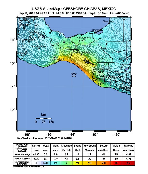
September 7, 2017 – A magnitude 8.0 earthquake has occurred OFFSHORE CHIAPAS, MEXICO at: 15.13N 93.95W Depth 10km 08/09/2017 at 04:49:14 (Universal Time)
Location with respect to nearby cities:
97 km (60 miles) SW (221 degrees) of Pijijiapan, Chiapas, Mexico
107 km (66 miles) WSW (245 degrees) of Mapastepec, Chiapas, Mexico
117 km (73 miles) S (182 degrees) of Tonal�, Chiapas, Mexico
165 km (102 miles) W (275 degrees) of Tapachula, Chiapas, Mexico
356 km (221 miles) W (278 degrees) of GUATEMALA CITY, Guatemala
Summary
This earthquake is expected to have a high humanitarian impact based on the magnitude and the affected population and their vulnerability.
- Earthquake Magnitude: M8.0
- Depth: 10 Km
- Event Date UTC: 08 Sep 2017 04:49
- Exposed Population: 120000 people within 100km
Whether international humanitarian aid is needed must be decided by an expert.
See the GDACS website for live news coverage (including OCHA Situation Reports), the full earthquake report and tsunami report
For information on emergency response, please consult the GDACS Virtual OSOCC.
THIS MESSAGE IS ISSUED FOR INFORMATION ONLY IN SUPPORT OF THE UNESCO/IOC PACIFIC TSUNAMI WARNING AND MITIGATION SYSTEM AND IS MEANT FOR NATIONAL AUTHORITIES IN EACH COUNTRY OF THAT SYSTEM.
NATIONAL AUTHORITIES WILL DETERMINE THE APPROPRIATE LEVEL OF ALERT FOR EACH COUNTRY AND MAY ISSUE ADDITIONAL OR MORE REFINED INFORMATION.
**** NOTICE **** NOTICE **** NOTICE **** NOTICE **** NOTICE *****
PRELIMINARY EARTHQUAKE PARAMETERS
———————————
* MAGNITUDE 8.0
* ORIGIN TIME 0449 UTC SEP 8 2017
* COORDINATES 14.9 NORTH 94.0 WEST
* DEPTH 33 KM / 20 MILES
* LOCATION OFF THE COAST OF CHIAPAS MEXICO
EVALUATION
———-
* AN EARTHQUAKE WITH A PRELIMINARY MAGNITUDE OF 8.0 OCCURRED OFF THE COAST OF CHIAPAS, MEXICO AT 0449 UTC ON FRIDAY SEPTEMBER 8 2017.
* BASED ON THE PRELIMINARY EARTHQUAKE PARAMETERS… WIDESPREAD HAZARDOUS TSUNAMI WAVES ARE POSSIBLE.
TSUNAMI THREAT FORECAST
———————–
Hazardous tsunami waves from this earthquake are possible within the next three hours along some coasts of:
Mexico… Guatemala… El Salvador… Costa Rica… Nicaragua… Panama… Honduras And Ecuador
There is no tsunami danger for the U.S. West Coast, British Columbia, or Alaska.