September 7, 2016 – Dry with above normal temperatures through the end of the week. Hazy at times due to fire smoke. Cooling to a little below normal early next week. A slight threat of Sierra crest thunderstorms by the middle of next week.
Discussion
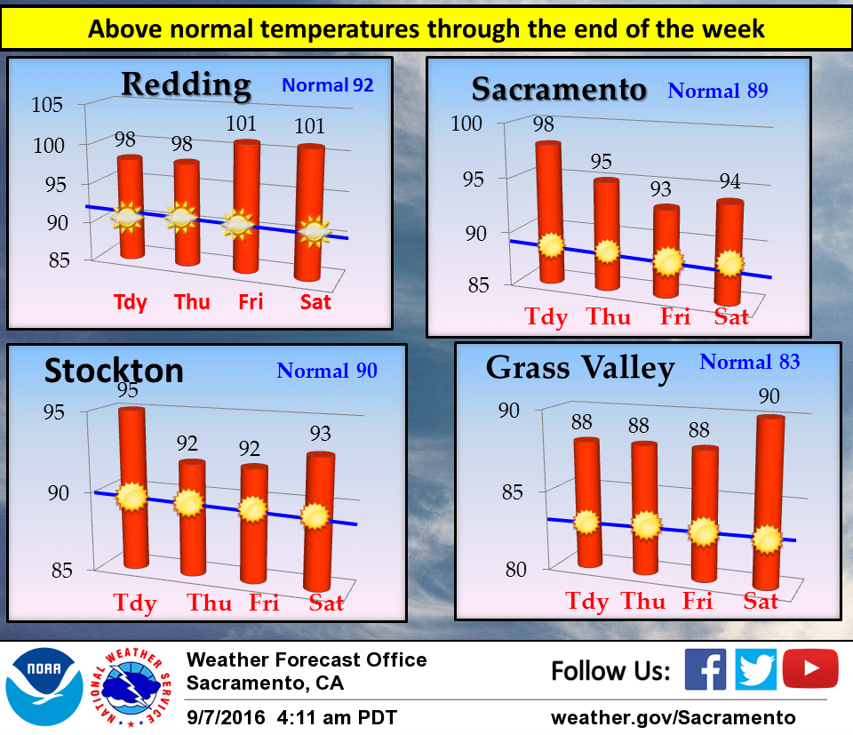
Flat high pressure will remain over the eastern Pacific and west coast through the end of the week bringing dry conditions and above normal temperatures. Surface pressure gradient from MFR to SAC over 9mb this morning. This is producing breezy north winds over the northern Sacramento valley, Sierra foothills and coast range. Upper support is limited and pressure gradients are expected to relax this afternoon so not expecting sustained winds more than about 15 knots today. Northerly pressure gradient is expected to return over the far north state over the next few nights but not as strong and with even less upper support. The north winds over the north end of the state are likely to bring smoke from the Gap Fire southward so some areas are likely to see hazy conditions over the next few days. Most areas should see a slight warm up today under a warming airmass under the building ridge and higher heights. This will bring daytime highs today to a few to several degrees above normal for this time of year. Overall airmass changes very little on Thursday so expect high temperatures to come in around the same as today. Exception will be in the delta influenced areas where a somewhat stronger delta breeze will bring a little cooler temperatures. Overall airmass warms a bit more on Friday for still warmer temperatures most areas. Exception again will be the delta influenced areas where a continued moderate delta breeze will bring a little more cooling. Generally little change is expected on Saturday. The west coast upper ridge flattens slightly as an upper trough passes to the north so some areas may see a slight cooling. The delta breeze weakens slightly on Saturday so delta influenced areas may see a little warming.
Extended discussion (Sunday through Wednesday)
Weak high pressure remains in control for the end of the weekend, with dry weather and temperatures within a degree or two of normal. Models continue to be in good agreement with trough that will drop down into the Great Basin early next week though vary slightly on strength. Trend has been slightly further west with the system over past few runs with models showing some precipitation across the Sierra by Tuesday. Instability progs suggest a few thunderstorms not out of the question as well. Have introduced some slight chance POPS along the crest during this timeframe. In addition, cooler temperatures look likely with some breezy winds. Depending on how models evolve track of system over next several days, may need to watch for fire weather concerns.