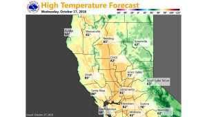
October 17, 2018 – Warm and dry this week. Chance of precipitation by the middle of next week.
Discussion
Clear skies continue across interior NorCal early this morning. Pressure gradients have slackened a bit further compared to 24 hours ago (MFR-SAC is below 4 mbs while the RNO-SAC is under 6 mbs), and overall wind gusts have decreased as a result. Still seeing a few spots in the northern Sierra and foothills with gusts above 30 mph. Dry weather with mild days and cool nights will continue through the remainder of the week as ridging over the eastern Pacific shifts over the PacNW and a weak trough lingers over SoCal. Lighter winds are expected as gradients relax further.
Extended Discussion (Sunday through Wednesday)
Weak upper low forecast to push across California on Sunday bringing minimal impacts to NorCal weather. Any precipitation associated with this low should remain south of the forecast area and even with a slight cooling, daytime highs are expected to remain slightly above normal.
Upper level Rex block pattern shifts into the Great Basin on Monday bringing slightly cooler temperatures but more importantly, the start of a transition to a cooler and possibly wetter weather pattern. Models are in fairly good agreement in pushing a shortwave trough into the Pacific Northwest and Norcal on Tuesday. Models do differ a bit on depth of this system but currently keep precipitation threat over the northern portions of the CWA. Backed off somewhat on expanse of precipitation chances using latest NBM as a guide.
Even with the cooling effect and cloud cover, current forecasts still keep daytime highs Tuesday slightly above normal. Another shortwave trough is forecast to move into the Pacific Northwest next Wednesday for another degree or two of cooling but this still looks to be a far northern California precipitation producer.

