February 23, 2021 – Warm and dry weather continues today with cooler weather expected for the remainder of the week. Breezy northerly winds thru mid- week, strongest on Wednesday. A passing weather system may bring a few showers to the northern Sierra on Saturday, then better precipitation chances return next week.
Discussion
Satellite imagery shows plenty of high clouds moving across NorCal as the upper-level front moves in ahead of the strong short-wave pushing across the PacNW early this morning. A modest barrier jet has developed along the western edge of the Sacramento Valley with northerly gusts in the teens to lower 30s mph being reported, and enough easterly gradient remains (RNO-SAC presently at 4.5 mbs) for gusts in the 30s mph over the high Sierra, and locally near the southwest facing canyons in the foothills.
Northerly breezes will become more widespread through the Central Valley today. It looks like most of the area will remain below wind advisory criteria today, but there is potential for some stronger gusts in the Delta from late morning into mid-afternoon.
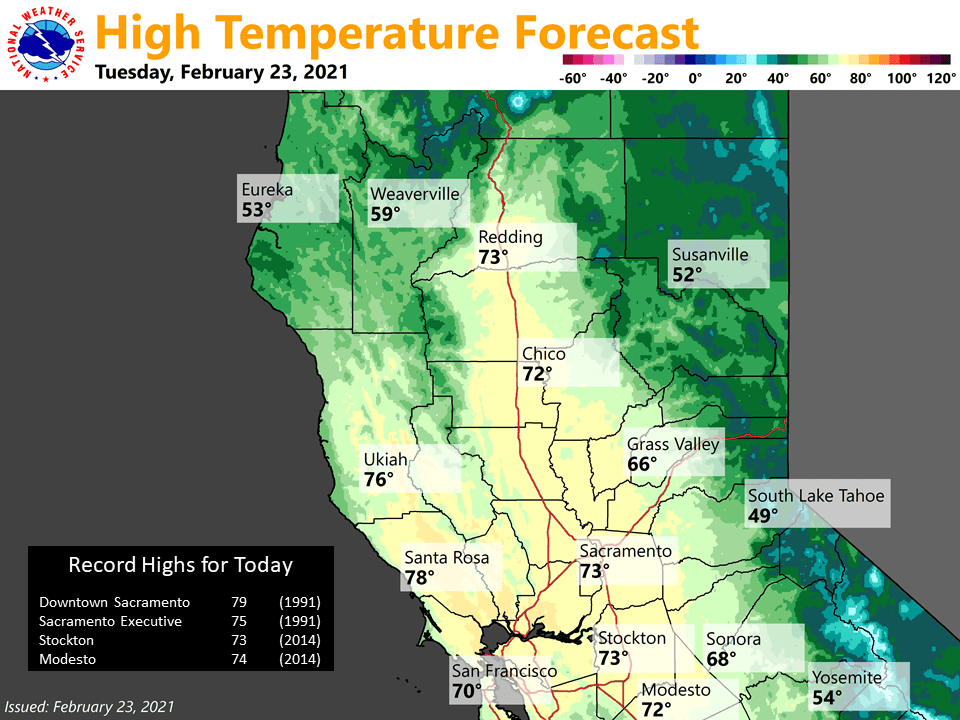
Cold-advection will likely cool max temps a bit across the northern Sacramento Valley today, but likely won’t have much effect further south where there will be potential for daily records in the Sacramento area and across the northern San Joaquin Valley as highs in the lower to mid 70s are expected.

Stronger northerly breezes are expected in the Central Valley Wednesday (and stronger easterly breezes over the northern Sierra Wednesday night). A wind advisory has been posted for the Sacramento Valley and Delta from late-morning thru the evening. The forecast surface pressure gradient and upper support aren’t looking quite as impressive as the past couple of days, and ensemble meteograms are down slightly on wind speed, but we’ll still likely see gusts in the 40-45 mph range in the valley. Temperatures will be down around 5-10 degrees compared to today.
Lighter winds and milder temperatures are forecast to return Thursday as ridging briefly rebuilds. Another series of short- waves will pass to the north Friday with perhaps a few showers developing over the far northern mountains Friday night.
Extended discussion (Saturday through Tuesday)
Ensemble guidance shows upper level ridge remains locked in place over the eastern Pacific this weekend. On Saturday, both GEFS and Euro ENS depict a positively-tilted trough digging south from the PacNW through the Great Basin and into California, a typical “inside slider” event. If the pattern holds, this will likely bring another offshore wind event to interior NorCal. Strength of winds are a little uncertain but current forecast has gusts 20 to 35 mph in the Valley and foothills, locally up to 45+ mph over the mountains.
There could be a few showers over the mountains with this system, though accumulations would remain limited. Brief ridging returns Sunday with locally gusty north winds lingering. The pattern becomes more uncertain for early next week.
Both the GEFS and Euro ENS indicate a trough could bring precipitation chances back into the forecast for early next week. However, location and timing of the trough are quite different with current runs, so confidence is low on specific details at this time.