
MARYSVILLE January 20, 2017 – Caltrans is alerting motorists traveling to the Sierra mountains, particularly those traveling on Interstate 80 (I-80) over Donner Summit or U.S. Highway 50 over Echo Summit, to be prepared for significant travel delays. Cold temperatures, heavy snowfall and windy conditions are forecast to continue through Monday, January 23.
The National Weather Service (NWS) has issued a Winter Storm Warning, predicting up to 6 feet of snow for summit passes and continued snowfall for mountain and Lake Tahoe areas. High winds are predicted for Friday as well as Sunday-Monday when low-visibility, whiteout conditions may occur. Additional snow accumulations, combined with high winds, will increase the risk of falling trees or downed power lines causing power outages. Motorists should call 911, when safe to do so, to report obstacles on the roadway.
Chain controls on state roadways throughout the higher elevations should be expected. Heavy rainfall in lower elevations increases the potential for flooding. Area roadways may experience mud or rock slides.

State Route 49 is currently closed north of Camptonville due to a mudslide with only local residents or deliveries allowed between Depot Hill and Sattley. Flooding is also a concern in foothill elevations. Motorists are cautioned to not drive into water-covered roadways.
The National Weather Service is also warning of increased avalanche hazards, especially with 100+ mph winds predicted for summit locations. U.S. Highway 50 over Echo Summit is open, but traffic may be held intermittently during the storm for avalanche control. Highway 89 over Emerald Bay is currently closed due to avalanche hazards. It will remain closed indefinitely until there’s a break in the weather and the snow and fallen debris can be cleared. Traffic on Interstate 80 may also be held intermittently to clear traffic incidents or if low-visibility conditions occur.
Be advised that motorists using cable (ladder) chains may be turned around on Highway 267 at the Northstar and Kings Beach chain control checkpoints. Although cable chains are legal traction devices, they’ve proven to be ineffective when attempting to drive over Brockway Summit during heavy snow storms. Motorists can use Highway 89 as an alternate route. Access to the Northstar resort area is open for motorists traveling from the Truckee area.
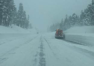
Caltrans’ snow removal crews continue working to clear summit passes and impacted Caltrans roadways. Caltrans permitted and trained chain installers on Interstate 80 can be identified by a reflective sign with their bib number. Caltrans encourages motorists to slow down and move over whenever flashing lights are observed on the region’s roadways.
Motorists are encouraged to plan ahead by following the winter driving tips listed at: http://www.dot.ca.gov/cttravel/winter.html:
- Check out Caltrans’ “QuickMap” for current road conditions and chain requirements at http://quickmap.dot.ca.gov. A mobile version is also available.
- Motorists also can use the California Highway Information Network automated phone service by calling 1-800-427-ROAD (7623).
- Motorists can see real-time conditions before they hit the road by using our map of traffic cameras available for District 3 and statewide.
- For Interstate 80 and Highway 50 updates, follow Caltrans District 3 on Twitter and Facebook to receive the latest information about current roadway conditions.
- For forecast information, visit the National Weather Service website.
Motorists are urged to be “Be Work Zone Alert” and to “Slow for the Cone Zone.” Caltrans will issue updates on Twitter @D3PIO and on Facebook at CaltransDistrict 3.