Cooling trend through the remainder of the week as high pressure weakens. Shower chances spread south over the weekend.
Discussion
Clear skies cover the region early this morning. Stratus is more extensive and extends well inland across the Bay Area. Profiler data indicate its depth has increased to around 1.5-2k ft. Surface pressure gradients are trending toward increased onshore, but little cooling has yet to be realized inland as most locales are reporting temperatures similar to 24 hours ago.

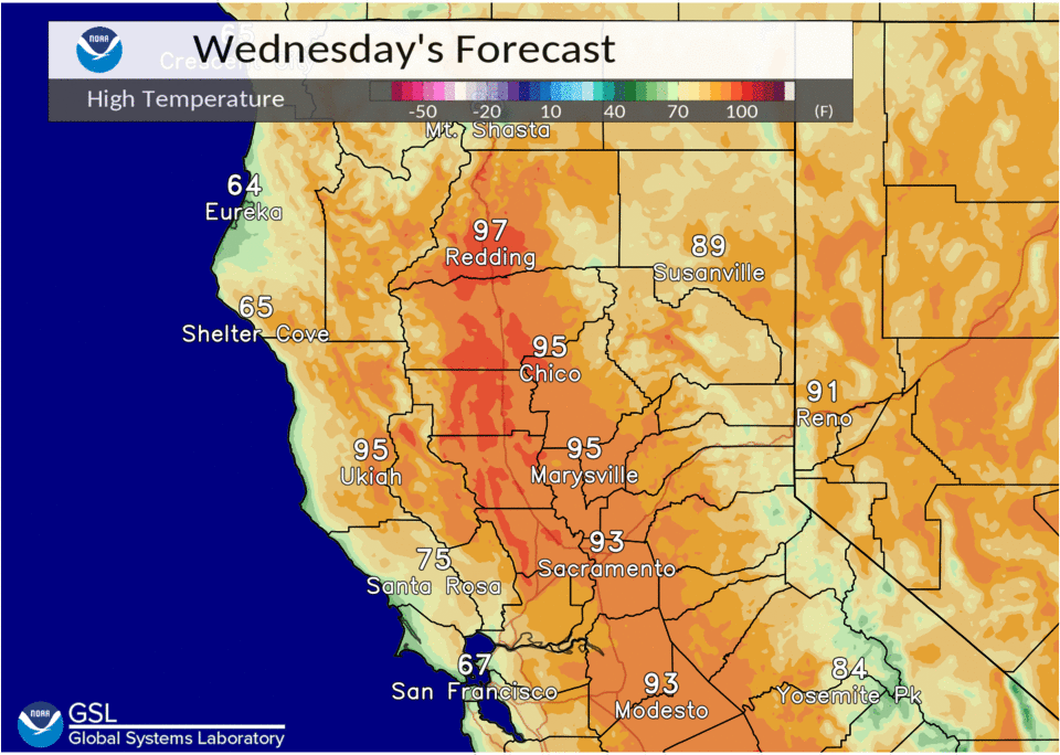
The strong ridge over NorCal will flatten today as a trough passes to the north across the PacNW. While temperatures won’t be as hot as Tuesday, readings will still be around 5-10 degrees above average today with the hottest readings expected to approach the century mark across the northern Sacramento Valley.
The cooling trend will continue Thursday as a weak short-wave is forecast to move across the region bringing increased onshore flow. Highs are expected to cool to around average, or slightly below.
Ensembles continue to indicate a deeper trough will approach the region late this week. Ridging ahead of the trough on Friday may bring a brief reprieve in the cooling trend before cooler and breezier weather arrives over the weekend with increased onshore flow bringing higher humidity. This is expected to mitigate fire weather concerns.

Still some uncertainty on how far south precipitation will spread over the weekend. GEFS is faster with light precipitation spreading about as far south as I-80 by early Sunday, while the EC keeps QPF over NW California through 12Z Sunday.
Extended Discussion (Sunday through Wednesday)
Pacific frontal system progged to move through interior NorCal over the weekend. Models have trended deeper with this system with frontal precip extending through most of the CWA now. Overall QPF looks light with any snow confined to the highest mountain peaks. Warmer and drier weather, with some locally gusty north to east wind expected early next week as EPAC high builds into the forecast area.