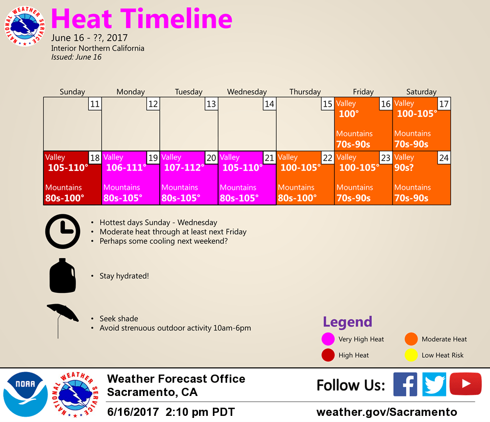
June 17, 2017 – An extended heat wave continues this weekend through most of next week with widespread highs over 100 degrees and warm nights. Isolated afternoon thunderstorms possible near the Sierra Crest and mainly south of Lake Tahoe Sunday and Tuesday, spreading into the northern mountains for Monday. Heat advisory now in effect from noon Sunday to 8 pm Wednesday.
Discussion
High pressure ridging is bringing hot weather to the area, and this is expected through the weekend into mid week, with a very gradual cool down by late next week into next weekend.
A Heat Advisory begins today for the Valley. This was upgraded to a Excessive Heat Warning for Sunday, which has been extended into Wednesday, with a Heat Advisory for the foothills. Triple digit highs are expected today, but even hotter weather is expected as the ridge strengthens, with highs peaking in the 105-110 range in the Valley for the Sunday-Tuesday period. Daily record highs are likely to be set in multiple locations. Some slight cooling with a weak Delta breeze is possible Tuesday, so portions of the southern Sacramento and northern San Joaquin Valleys may see peak temperatures on Monday. Other areas will see little change in the hot weather for Tuesday.
Northerly to northeasterly downsloping winds will keep temperatures very warm overnight. This particularly true for the foothills and northern Sacramento Valley, where lows could potentially remain in the low 80s. Opening windows at night will give little or no relief from the heat.
A somewhat moister than usual atmosphere with higher dewpoints could add to the feeling of the heat, particularly on Monday.
The Valley, Delta, and foothills are expected to remain dry with limited cloud cover. However, mid level moisture with afternoon heating will allow some showers and thunderstorms to develop over the higher Sierra Sunday, mainly south of I80. On Monday, enhanced elevated instability could spread afternoon and evening thunderstorms into the northern mountains. Some limited afternoon convection could linger over the Sierra on Tuesday, but conditions look much less favorable.
Extended discussion (Wednesday through Saturday)
Hot and dry conditions will continue during the middle of next week, then the upper ridge is forecast to weaken somewhat later in the week resulting in moderating temperatures back to around average by the end of the week.