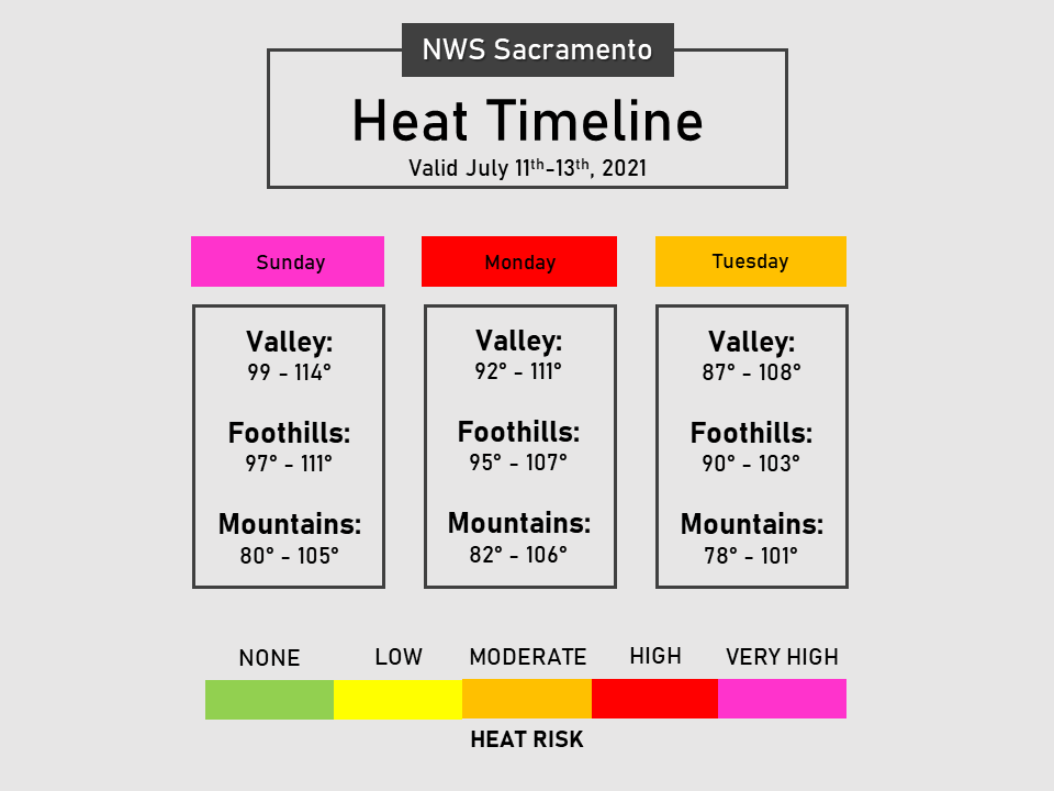
Dry conditions with very hot temperatures expected through early this week. An Excessive Heat Warning is in effect for much of interior NorCal through Monday evening. Near normal temperatures return mid to late week.
Discussion
With the exception of the Delta region, dangerous overnight lows are expected early this morning with many areas seeing little to no relief from the heat. The warmest lows will be seen in the thermal belt and across the northern Sacramento Valley with lows in these areas ranging from the upper 70s to upper 80s. Onshore winds continue today -strongest in the Delta- and will help to limit high temperatures close to this region with only moderate heat risk expected. Due to this, have continued the Excessive Heat Warning for all areas below 6kft with the exception of the “cooler” Delta area.

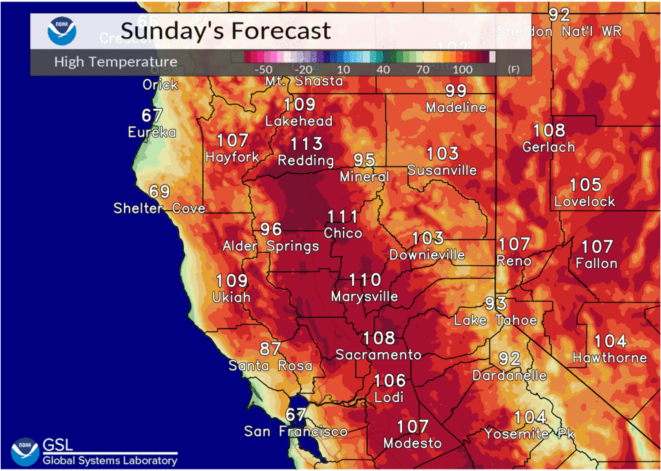
Highs in the Valley and foothills will be hot again this afternoon with most locations reaching 100+ degrees. Very high heat risk is expected again today due to the combination of warm overnight lows and hot afternoon temperatures.
High pressure begins to flatten a bit tonight into Monday, with a weak shortwave moving across the PacNW. Stronger onshore flow is expected tonight and tomorrow which will bring cooler temperatures to portions of the southern Sacramento and northern San Joaquin Valleys, including areas near the Delta. The Excessive Heat Warning has been dropped for these areas for Monday, with the warning continuing for northern Sacramento Valley and the thermal belt of interior NorCal through Monday night.
High pressure then shifts slightly south of the area Tuesday and Wednesday, with weak troughing beginning to work its way into the area from the PacNW. This will allow for additional cooling Tuesday and Wednesday with highs just slightly above normal values for mid- week. Dry weather continues.
Extended Discussion (Thursday through Sunday)
Ensemble guidance continues to depict weak troughing over Northern California for the second half of next week as an upper level low forms off the coast. This will push the high pressure east over the Great Basin and allow for temperatures to continue lowering with near normal temperatures forecast across the entire forecast area Wednesday into the weekend. Redding could potentially break its current streak of consecutive 100+ degree days Thursday or Friday by falling just short of 100 degrees. This pattern will also bring an increase in onshore flow.
Locally breezy winds are forecast in the Delta region and over the higher mountain elevations, especially Thursday and Friday. The mid- levels continue to look dry which would limit any thunderstorm chances with this troughing.