March 25, 2017 – Lingering mountain showers today then another storm moves through Sunday into Monday. Drier Tuesday followed by a threat of another storm midweek.
Discussion
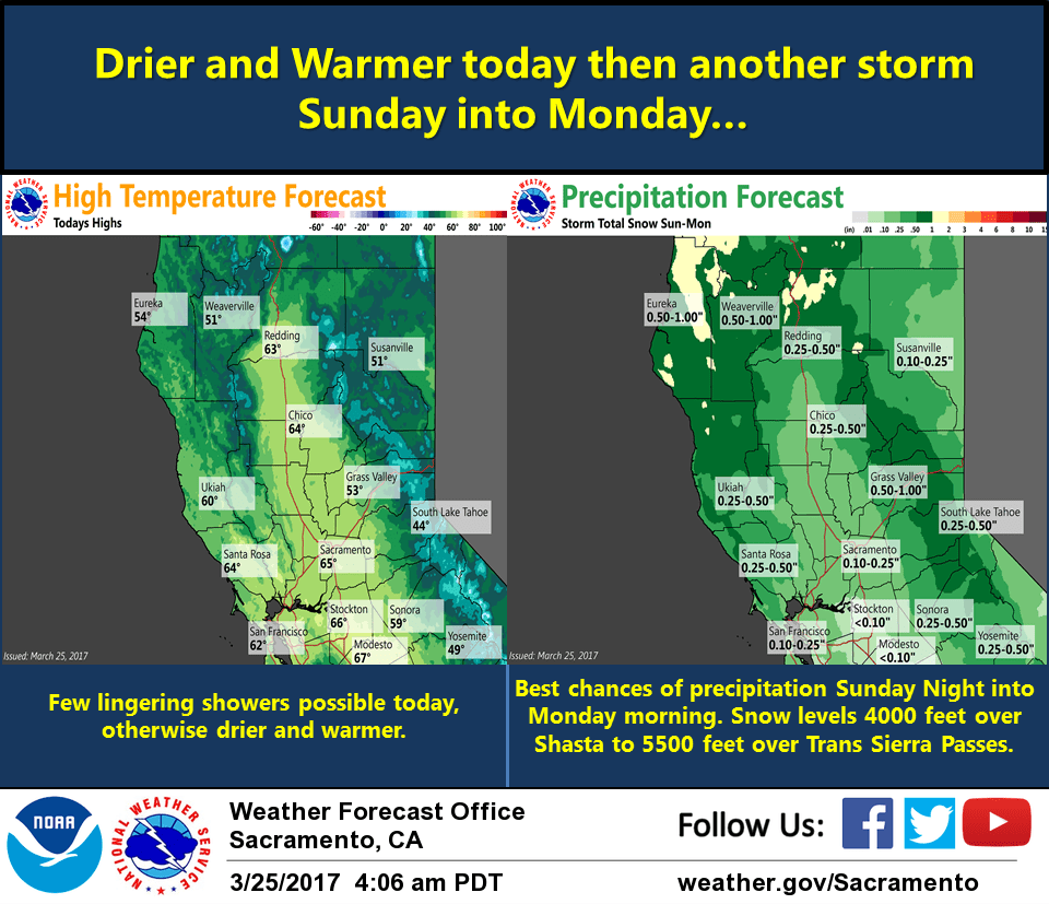
Low pressure system continues to move east of our area today. A few lingering showers persist this morning and will be ending soon. Another weak weather system will move through the area Sunday/Sunday night. Outside of some snow for the mountains no major impacts are expected.
Previous Discussion
Upper trough axis shifts into the Great Basin this morning with lingering showers possible over the mountains. Some patchy morning valley fog may develop.
Otherwise, dry weather forecast today into tonight as upper level ridge moves through. Next Pacific storm begins to bring a threat of precip into the Northern Shasta mountains after midnight then across northern and western portions of the forecast area on Sunday.
Bulk of precip modeled to move across the CWA Sunday night with showers Monday, mainly over the mountains. Storm total QPF amounts look to be around half an inch or less in the Central Valley, except up to an inch possible in portions of the Northern Sacramento Valley.
Liquid equivalents in the foothills and mountains look to be upwards of 1 to 2 inches. Snow levels forecast to be around 4000 to 5500 feet during the peak precip period and snow totals point to advisory amounts at this time. Some breezy conditions possible Sunday afternoon into evening but wind speeds remain below advisory criteria.
Increasing subsidence over the area Monday night into Tuesday as upper level ridging in EPAC builds inland. Surface high also builds inland across Oregon into the Great Basin. This will increase the low level N-S pressure gradient over Interior NorCal. Tightened surface gradient along with momentum transfer from stronger winds aloft will result in some breezy northerly wind over the CWA Monday night and Tuesday. Above normal temperatures expected Tuesday with highs in the lower 70s for the Central Valley with 50s to 60s for the mountains and foothills.
Extended discussion (Wednesday through Saturday)
Generally dry weather late next week as high pressure builds over NorCal, except for a slider system forecast to drop southeast from the Pacific Northwest on Thursday. Showers with this system will be limited to mainly the northern mountains and northern Sierra Nevada. Otherwise, breezy northerly winds expected at times along with milder temperatures.