June 17, 2021 – Widespread triple digit heat expected for the lower elevations into the weekend. High to very high heat risk is expected with well above normal temperatures. Excessive Heat Warning until 9 PM Saturday.

Discussion
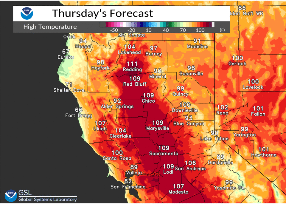
Strong high pressure centered around the four corners area will bring very hot temperatures today for the interior. Temperatures will top out around 110 for most valley places with some of the warmest spots topping out around 113 degrees.

Northerly winds are expected to increase by afternoon to 10 to 15 mph within the valley with some higher gusts that will increase fire danger today on top to the intense afternoon heat. Some high clouds drifting north this morning should thin for the afternoon and do little to help keep temperatures down.
A strong thermal belt will keep some of the warmer foothill locations very warm tonight only cooling off into the upper 70s to mid 80s. The rest of the area will cool off into the mid 60s to mid 70s.

Little change is forecast for most locations Friday’s highs but the winds do switch direction with some dry warm flow coming through the Delta and winds becoming upvalley during the day. Only some cooling over Thursday’s highs is expected for the Sacramento region.

Another very warm night is forecast for the foothills for Saturday morning with slightly better cooling for the Sacramento region that will still lead to a very hot day for the interior. Some moisture coming up from the south may clip the far southeastern area of the mountains but for the most part the majority of the activity is expected to stay south and east of out forecast area.
Sunday a low forms off the coast that at this point is forecast to bring some cooling to the interior. The marine layer may make a greater presence along the coast by then to help cool parts of the interior as well but the downward trend in temperatures should continue.
Extended discussion (Monday through Thursday)
Upper ridge moves into the Great Basin early next week as upper low off the CA coast gradually shifts inland. This will result in a cooling trend Monday into Wednesday with high temperatures near normal by midweek.
Models differ with progression of the low but keep the forecast dry at this time. Highs Thursday expected in the upper 80s to mid 90s in the Central Valley with upper 60s to mid 80s for the mountains and foothills.