December 12, 2016 – Dry today followed by potentially significant rainfall and mountain snow Tuesday through Friday.
Discussion
Lots of cloudiness continues across most of interior NorCal early this morning. Stratus covers the entire Sacramento Valley except for the north end around Redding. With all the cloud cover, temperatures are relatively mild ranging from the 30s in the mountains to the 40s elsewhere.
Zonal flow will continue across the region today with dry conditions expected to continue. Satellite imagery hints that there may be a break in mid and high clouds by this afternoon, but it’s looking doubtful that much of the valley will be able to completely clear out from the low clouds.
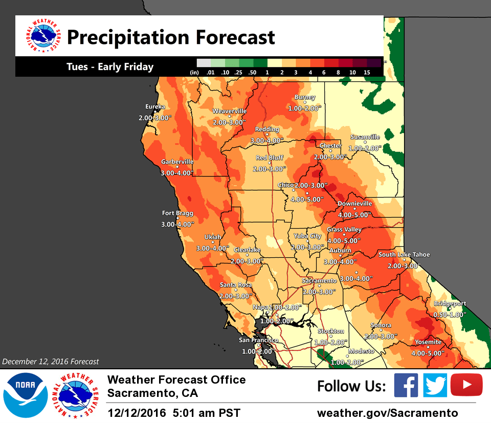
The next storm system moves in Tuesday. This system will have a very wet plume of moisture, similar to the one which brought heavy precipitation early in the weekend. It’s now looking like most of the precipitation with this next wave will be to the north of I-80, and shift even further north on Wednesday as ridging amplifies along the West Coast ahead of the next upstream trough.
There will be potential for snow impacts for mountain travel Tuesday into Wednesday before warm-advection brings rising snow levels and the main precipitation swath shifts north. A winter weather advisory has been posted for 4-8 inches snowfall accumulation above 5500 feet.
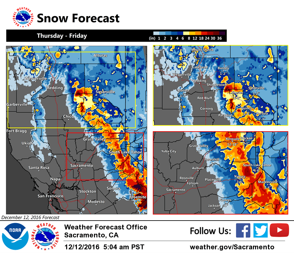
The bigger weather event this week appears to be lurking for Thursday and Friday as next trough approaches NorCal and interacts with the deep moisture plume. The system is forecast to progress through the region, but it still looks like a 12-18 hour period of moderate to heavy precipitation for many areas. With lowering snow levels, this storm has the potential to bring several feet of snowfall accumulation to the higher elevations.
In addition, strong southerly pressure gradients develop by early Thursday as deepening surface low skirts the NW coast of California, so many areas will see strong gusty south winds ahead of the front and main precipitation band.
While river and stream levels will have a couple days to lower some after the latest wet event, they will still be elevated. The abundant rainfall expected this week combined with the sufficiently wet ground from the most recent storms could be enough to cause another round of smaller river/stream and street flooding, so the flood watch will continue.
Extended discussion (Friday through Monday)
Broad upper level troughing pushes inland across the area on Friday, with the tail end of Thursday’s system keeping showers going, mainly across the mountains. Colder air wrapped in system could drop snow levels into the foothills with a few inches of accumulation down to ~2500 feet. This may depend on how fast system pushes out during the day with model differences this far out. Regardless, impacts on mountain travel may continue into the day Friday. A few showers could linger into Saturday as upper low pushes SE out of the area. Northerly flow and ridging will then build into the region for the rest of the weekend into early next week, allowing the area to dry out. Below normal temperatures will rule thru the extended period with several chilly nights possible.
NID says that Bowman Lake filled during this last big storm is starting to spill
Most likely this spilling will increase and continue through this next big storm
This impacts Canyon Creek in Little Town of Washington