Dangerous heat will persist through today. Smoke from area wildfires will continue to impact portions of interior northern California. Thunderstorms are possible over the northern Sierra Nevada this weekend into early next week.
Discussion
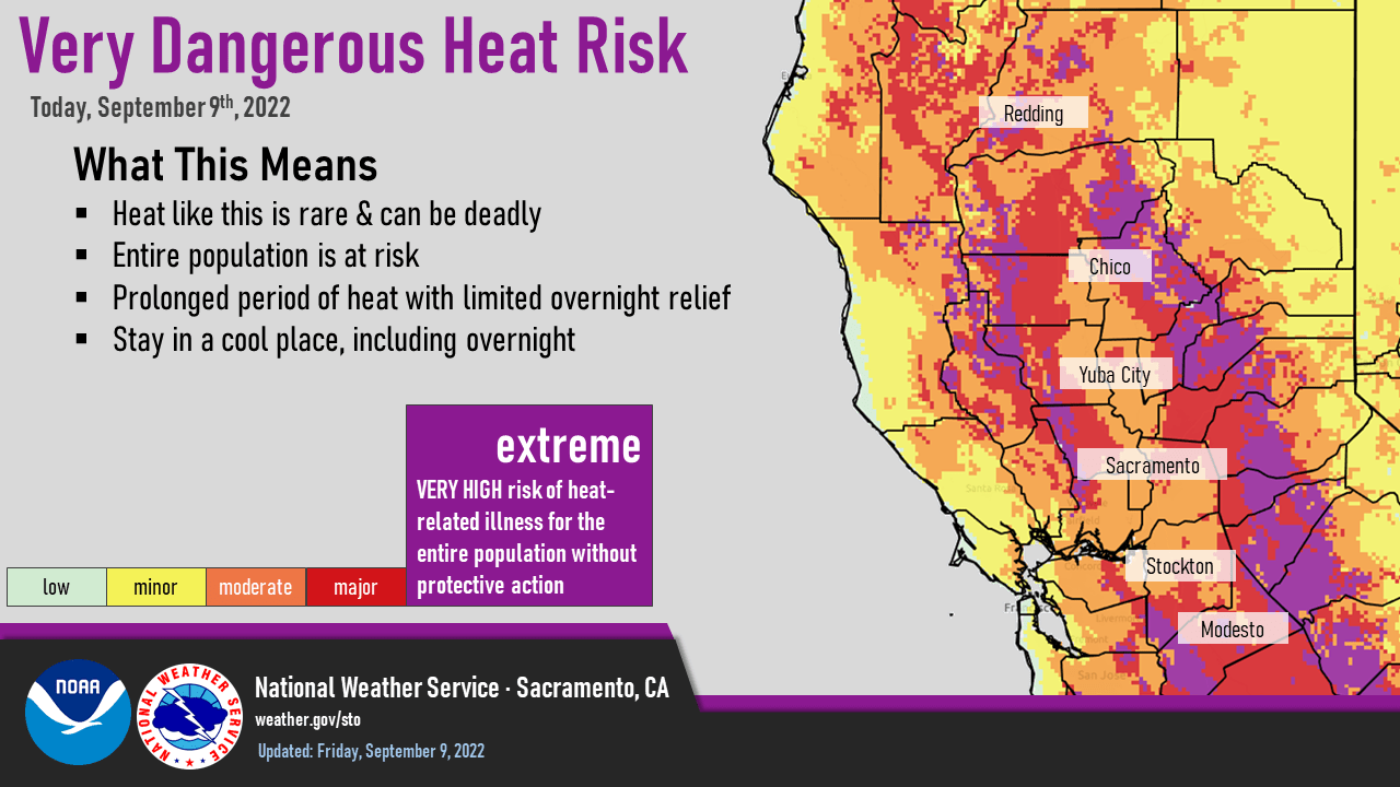
This will be the last day of dangerous heat with near record and record heat for the interior. The mountains and foothills have been trending cooler this morning but the valley is still slightly warmer as of 3 am.
Smoke from the mosquito wildfire has spread into the southern Sacramento valley so this may end up having an impact on today’s high temperature forecast. Radar and Satellite heat imagery are indicating that the wildfire is still very active this morning.
Smoke is projected to push to the east this evening as winds from the Delta increase improving air quality over the Southern Sacramento valley and lower foothills.

Isolated showers or thunderstorms will be possible again today mainly south of Alpine county.
Tonight we are looking at the return of the Delta Breeze which will be of moderate to strong in strength so expect a faster cool down this evening for the interior.
Moisture from current hurricane Kay will spread clouds over the region Saturday helping to bring significant cooling over this weeks temperatures with highs expected to range from the mid 80s to mid 90s in the valley. This will also bring a chance of showers and thunderstorms this weekend. At this time thunderstorm activity seems limited to the Sierra Nevada and mainly south of Lake Tahoe each day through Monday. Some shower activity may spread further west into the foothills and eastern San Joaquin valley on Sunday.

Mostly cloudy conditions will continue on Sunday and a decent trough of low pressure off the coast will also help to bring synoptic cooling to the region as well with temperatures expected to be mainly in the upper 80s to lower 90s for the valley both Sunday and Monday.
Extended Discussion (Tuesday through Friday)
Long wave trough resides off the West Coast through the extended forecast period as series of short waves move inland. Increased onshore flow and synoptic cooling will result in below normal high temperatures with 80s in the Central Valley. Slight chance of afternoon showers and thunderstorms over the Sierra Nevada Tuesday and Wednesday.