October 2, 2016 – A weather system with unseasonably cool temperatures, and periods of Valley rain, mountain snow, and possible thunderstorms continues into early Tuesday. Drier weather expected by the middle of this week.
Winter Weather Advisory until 5 AM PDT Monday for West Slope Northern Sierra Nevada-Western Plumas County/Lassen Park.
National Weather Service-Reno has issued a Red Flag Warning in effect from noon today to 6 PM this evening for gusty winds and low humidity for Mono and Eastern Alpine Counties.
Discussion
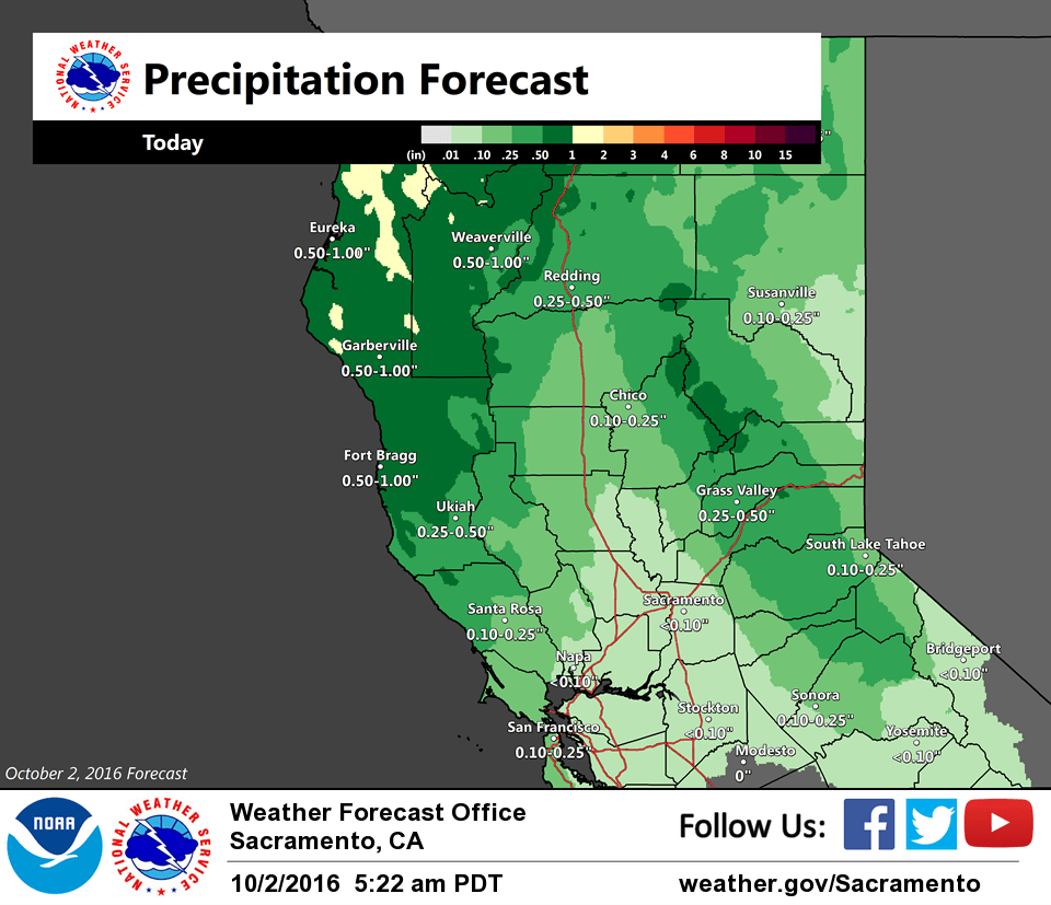
Clear skies continue over much of the area, but this will change quickly as a narrow frontal band located behind a line from around Red Bluff to Clear Lake pushes to the southeast. Some rain has been falling from this band, with around a half inch along the coast to around 0.05-0.10″ over the eastern side of the Coastal Range in western Shasta and Tehama counties so far this morning. This will gradually spread through much of the area, though high resolution models suggest that it will weaken as it moves to the southeast. Much of the precipitation will be north of I80, especially with the initial frontal band.
A concern this afternoon is for thunderstorms to develop in the clearing skies behind the front, with a brief lull in the precipitation. Solar heating timed with the cold core aloft could be enough to generate some thunderstorms over the Valley and into the foothills. The best potential looks north of I80, though some models hint that an isolated thunderstorm could reach as far south as Stockton/Modesto. While modeled shear in the lowest levels is fairly marginal, there is ample shear higher up. Will be watching closely to see if conditions to develop for severe weather, though expect it would be rather isolated.
A Winter Weather Advisory takes effect after 11 am, due to the potential for some early season snow. This could begin in the late morning for the Lassen Park/western Plumas County area, then arriving in the Sierra in the early afternoon.
Extended discussion (Thursday through Sunday)
Dry through the extended period under upper level high pressure. Temperatures will be warming through the extended period reaching just a little below normal by Sunday. Breezy northerly winds will be decreasing on Thursday as pressure gradients relax. A weather system passing to the north early Saturday will turn winds to more westerly but otherwise have little impact on CWA weather with any precipitation remaining north of the forecast area.