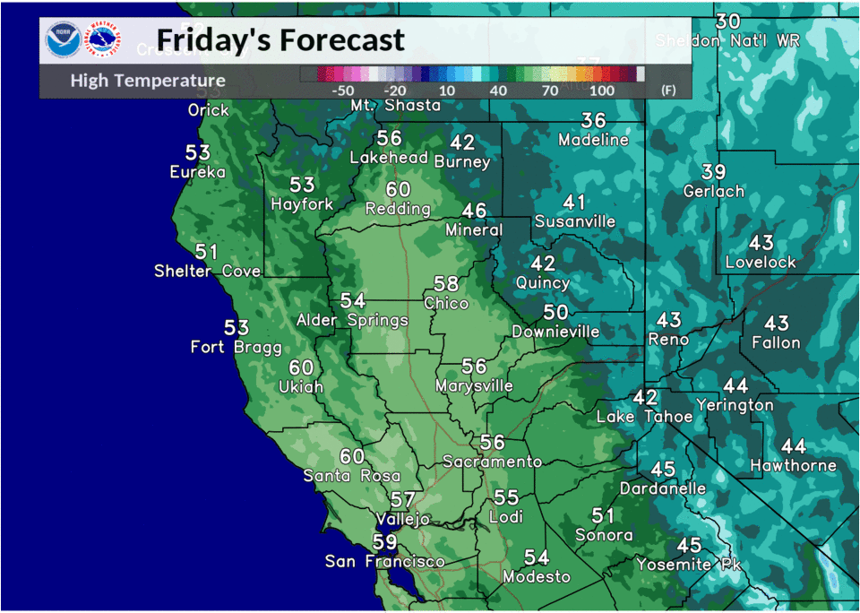
December 18, 2020 – Dry and quiet weather into the weekend with mild afternoon highs and chilly overnight lows. Patchy dense fog will be possible during the overnight and morning hours Friday into the weekend. Slight chance for mountain showers early next week.
Discussion
Satellite imagery this morning shows a thin strip of fog and stratus along the Motherlode, which coincides with the lightest winds in the area. Hi-res model guidance suggests that this could expand more into the foothills and then westward towards highway 99. Current thinking is that there is a chance for patchy fog between these areas as winds should ease up as we heads towards daybreak. Elsewhere, northerly winds remain a touch to strong to support widespread fog development this morning. This is due to the trough now sitting over the desert southwest and the eastern Pacific ridge trying to build over norCal. Ridging is expected to hold and keep us dry though the weekend; however, some high clouds will be possible later today due to a shortwave trough passing well to our north. Expect pleasant conditions with high temperatures generally 2 to 10 degrees below normal today.
By late tonight and tomorrow morning, high pressure is forecast to move over norCal. This will allow for some chilly temperatures, with Valley locations generally being 2 to 10 degrees below the seasonal average, while the mountains and foothills sit closer to their normals. In addition to this, winds will become light and with lingering moisture from Thursday’s rain, there will be a good chance for fog development across the Valley. After that, expect another dry day and above normal day.

Monday’s forecast is much of the same; however, the ridge is expected to be flattened a bit. Models and ensemble guidance show a quick moving trough clipping norCal, which could bring slight chance of light showers to the southern Cascades and high elevation Sierra. Precip amounts aren’t very impressive with this, but perhaps some areas will be able to squeeze out a couple hundredths.
Extended discussion (Tuesday through Friday)
A few showers will be possible over the northern mountains and northern Sierra Tuesday on the backside of a system dropping southeast into the northern Great Basin and Rockies. Otherwise, dry weather with mild days and cool nights is expected through the middle of next week under high pressure. Occasionally breezy north winds will limit overall extent of late night and morning fog across the Central Valley.
Both the GEFS and EC ensemble indicate potential for light precipitation returning to the region on Christmas and into next weekend as the pattern flattens and becomes more zonal. Stay tuned.