Hot and dry conditions gradually give way to moderating temperatures by mid-week.

Discussion
Satellite imagery shows a few mid and high clouds moving up from the southwest as a very weak trough develops along the West Coast. Elevated moisture/instability is pretty meager, so not expecting much other than a pretty sunrise. Surface pressure gradients continue to gradually trend toward overall onshore flow, and a moderately strong Delta Breeze persists. The marine layer is also continuing to slowly deepen and is presently between 1.5k- 2k ft deep.
The Delta Breeze continues to spread cooling inland across the lower elevations, and current temperatures are running around 2-6 degrees cooler across the Central Valley compared to 24 hours ago and range from the mid 50s near the Delta to around 80 up at Redding. Elsewhere, little relief has yet to make it into the foothills and mountains where current temperatures remain mainly in the 60s and 70s (with lower 80s in the warmest thermal belts).

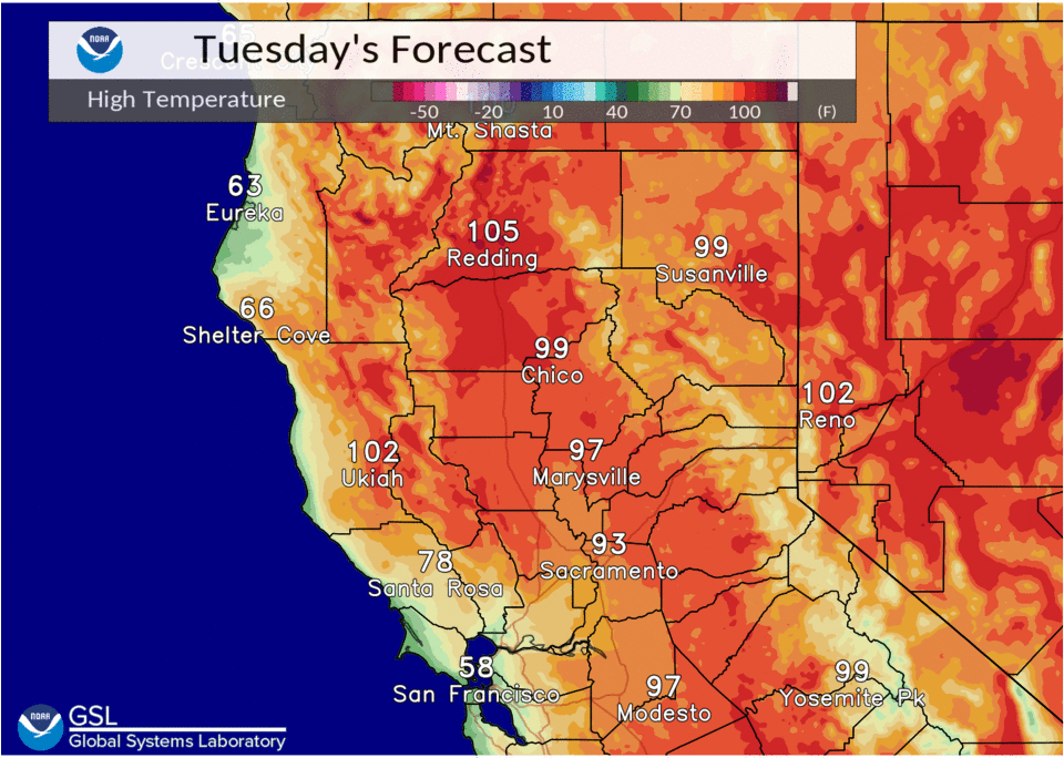
The Delta Breeze will continue to provide cooling for the southern half of the Sacramento Valley, and the northern San Joaquin Valley today and Wednesday. Hot weather will persist elsewhere with triple digit heat likely to continue across the north end of the Sacramento Valley.
High pressure forecast to weaken further Thursday and Friday and shift east as a more substantial weak trough develops along the coast. Onshore flow will persist, and coupled with slight synoptic cooling, will lead to further cooling across the region with highs forecast to lower to slightly below average. The streak of consecutive triple digit highs in Redding may finally come to an end.
Extended Discussion (Saturday through Tuesday)
We will continue to be in a troughing pattern for the start of the extended period. This will keep seasonal temperatures in place along with locally breezy onshore winds. Over the weekend the upper level ridge over the interior Mountain West will amplify and will begin to push to the west into early next week. This will bring the return of warmer temperatures with highs pushing back to around 100+ for the Valley. As the ridge pushes back west it will begin to pull moisture back north and we should see increased moisture build over the Sierra early next week. Currently models don’t have much in the way of CAPE over the Sierra on Monday but this will likely change as we get closer in time. Given the moisture and the pattern set up a few isolated thunderstorms will be possible in the higher elevations south of I-80 early next week.