September 27, 2016 – Strong high pressure will continue hot weather across the region today. A cool down is expected as an upper level trough moves into northern California for the rest of the week and into the weekend.
Discussion
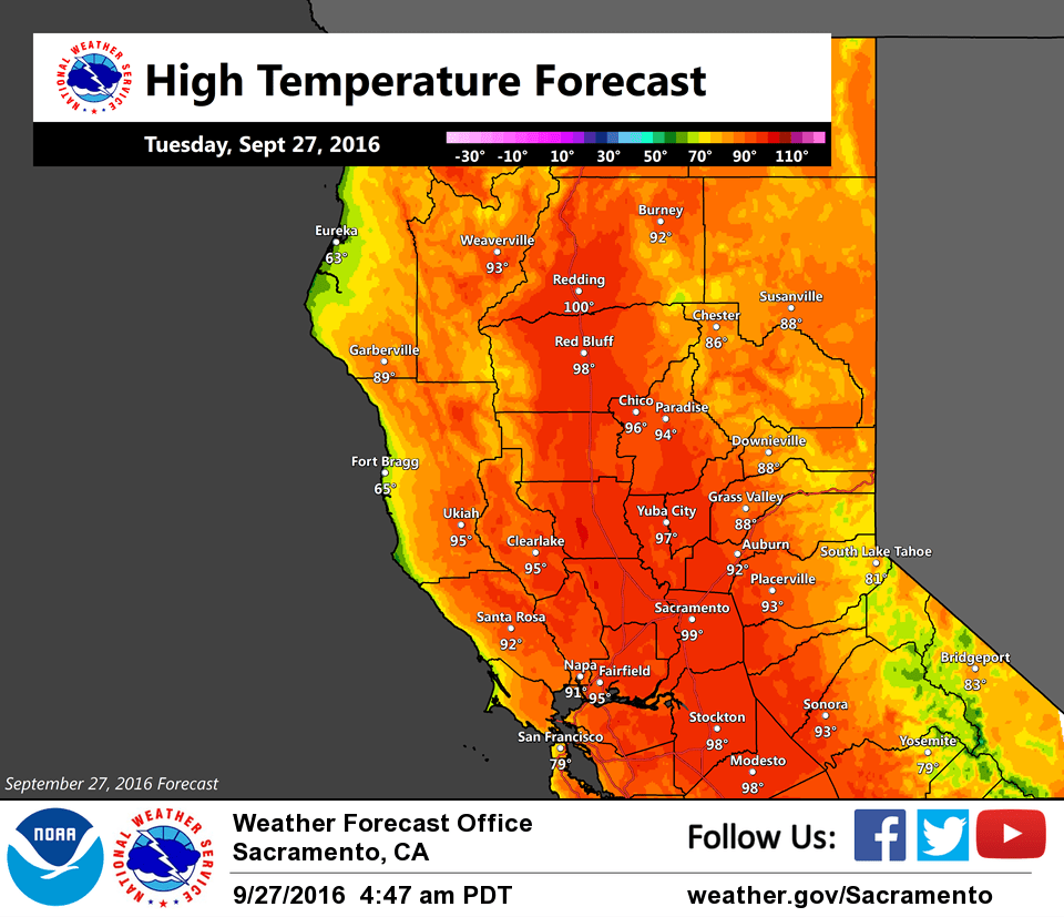
The hot weather pattern will continue across the interior of NorCal for another day as strong high pressure continues. The offshore surface pattern is not as strong as 24 hours ago, but the marine layer has yet to return. A weak Delta Breeze may develop by this afternoon and may shave a few degrees off today’s highs compared to Monday.
The Delta Breeze will pick up tonight and Wednesday as the upper ridge shifts east and a low drops down to off the PacNW coast. This will mark the beginning of a significant cooling trend across interior NorCal (and a return of breezy southwest winds) for the second half of the week from a combination of increased onshore flow and synoptic cooling associated with the trough. By Friday, highs across the region are expected to be around 20 degrees cooler compared to today.
Extended discussion (Saturday through Tuesday)
A cool trough from the Gulf of Alaska will bring a period of typical fall weather for the weekend into early next week. This means cooler temperatures and unsettled conditions, with periods of precipitation possible as a series of waves move through the trough. The initial wave late Friday through Saturday should be relatively dry and will bring a drop in temperatures to 8 to 11 degrees below normal levels. Mountain winds should be quite breezy/gusty, though increasing humidity levels will tend to decrease fire weather concerns.
The next wave arrives Sunday into Monday, but models differ significantly on timing and how far south this system will go. Overall there is a trend of this system looking wetter and shifting further south. Sunday there is a slight chance of precipitation over the northern mountains and into the northern Sacramento Valley, with snow levels in that area dropping around to just below 7000 feet. The best potential for precipitation is expected to be midday Monday, across the mountains and extending into the central Sacramento Valley. If models continue this trend, the potential for precipitation may spread across the forecast area. On Tuesday confidence is low but the general trend appears that this system should be exiting the area with some lingering mountain showers.