
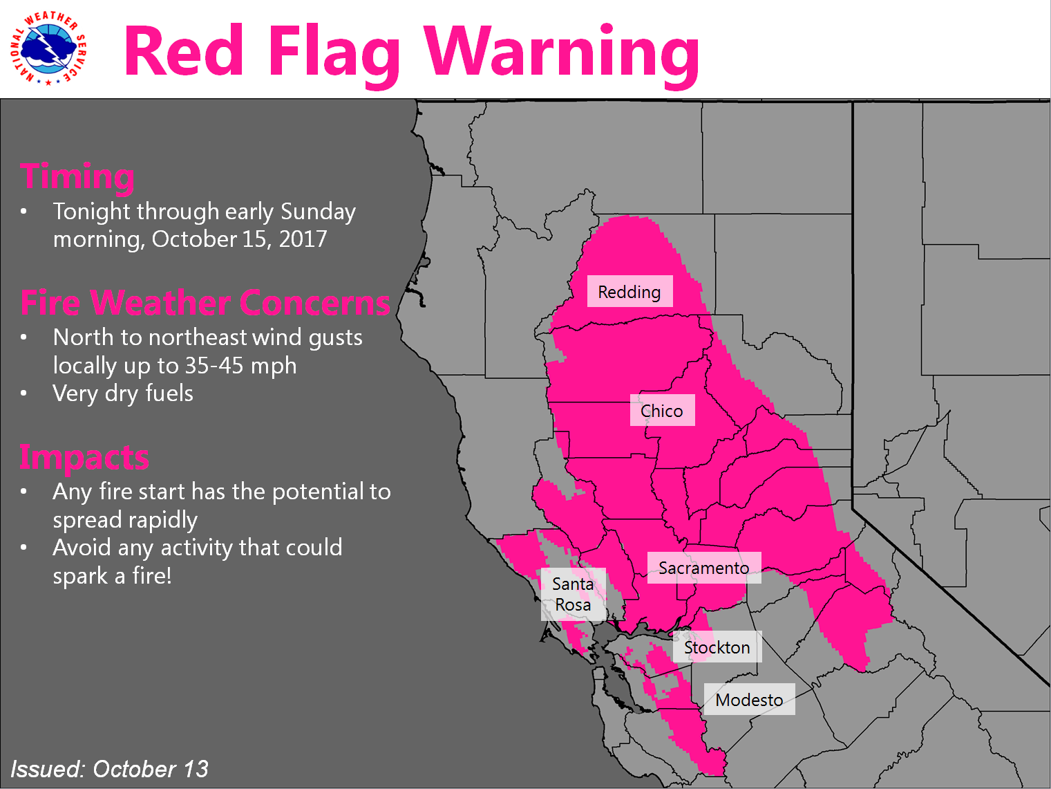
October 13, 2017 – Dry weather continues into early next week. Gusty north winds will return tonight into Saturday with critical fire weather conditions expected again. Chance of rain arrives late next week.
Discussion
Mostly clear skies prevail across interior Northern California this morning. Winds have largely dropped off across the region, with mixing levels dropping as a result. With a more stagnant boundary layer in place, visibilities near area wildfires are worse this morning than yesterday as smoke settles down to near the surface. Temperatures are also rather chilly this morning as the boundary layer decouples in most Valley locations. As of this writing, many Valley locales are in the lower to mid 40s.
A frontal system will pass through the Pacific Northwest today, then drop south into the Great Basin tonight into Saturday. No precipitation is expected with this system, but gusty north winds will likely develop behind the front. These winds should start to pick up tonight, with strongest winds early to mid Saturday. Some of the wind gusts over higher terrain could reach 40 to 50 mph. This wind event looks to be a bit stronger than Wednesday’s, but weaker than the event that started the fires Sun-Mon. A Wind Advisory and Red Flag Warning has been issued to address these concerns.
Winds should begin to taper off Saturday night into Sunday as an upper level ridge over the eastern Pacific builds inland. High temperatures will rise to a few degrees above normal, but fire weather concerns diminish a bit with decreasing winds.
Extended discussion (Tuesday through Friday)
Upper level flow pattern begins to transition in the extended period as the upper level ridge breaks down and a shortwave trough pushes through the Pacific northwest states Tuesday. As a result of the disturbance moving north of the forecast area, temperatures will drop a few degrees to near normal across northern California on Tuesday and Wednesday.
A larger scale trough and associated jet stream will approach the region Thursday into next Friday, which is shaping up to be the first decent chances for a precipitation event for the forecast area. Temperatures will decrease a bit more ranging between 5 and 10 degrees below normal with snow levels dropping to about 6000 feet. Light snow accumulations are expected at this time with most accumulations occurring at the highest Sierra peaks with minimal impact to travel.
Is it safe to light a woodstove for heat during this time – 10/13 to ???
From Nevada County Consolidated Fire Department’s Twitter feed: Burning in your wood stove is allowed but please remember to have your chimney inspected and a spark arrestor screen on your chimney!