September 21, 2016 – A few light showers south of Sacramento this morning. A slight chance of showers or thunderstorms across the far northern mountains and Sierra today and Thursday. Breezy winds over the southern Cascades today with a Red Flag warning there today for winds and low RH. Cooler than normal temperatures through Friday then warmer than normal over the weekend and into next week.
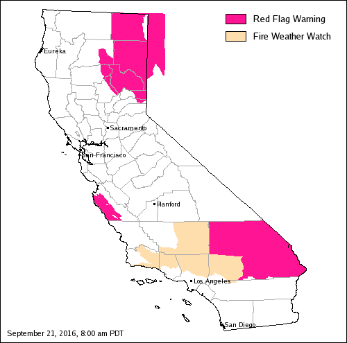
Red Flag Warning from 11 AM this morning to 8 PM this evening for Northern Sierra Including Lassen NP and Plumas and Lassen NF/S West of the Sierra Crest (West of Evans Peak-Grizzly Peak-Beckworth Peak).
Red Flag Warning remains in effect from noon today to 8 pm this evening for gusty winds and low humidity for the Sierra Front and the Basin and Range north of Interstate 80.
Discussion
Northern California under southwest flow aloft between high pressure over the central U.S and a low pressure system off the Pacific Northwest coast. A shortwave disturbance moving through this southwest flow is currently bringing some light showers south of about Sacramento. This area of showers will slowly shift to the east during the morning hours.
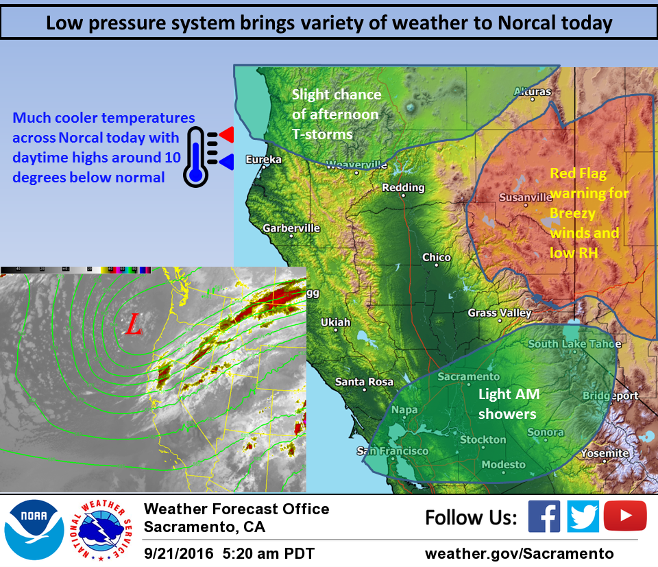
Breezy onshore flow expected today most noticeably through the delta and over the southern Cascades where a Red Flag warning is currently in place. The upper trough axis is forecast to move inland this afternoon and evening. Should see enough instability and dynamics across northern Shasta county for a slight threat of thunderstorms today. All other areas will see a significant drop in temperatures today as cooler air associated with the low filters into the region. The upper low digs to the southwest tonight and Thursday. As is does, the shower threat shifts to the southeast as well with this threat working southward into the northern Sierra by Thursday afternoon. There is not a great deal of instability with this system but enough to justify the slight thunderstorm threat. As the upper trough moves into the Great Basin northerly flow develops across the north state. Cool airmass and this northerly flow will keep daytime highs Thursday well below normal. As the upper trough continues east on Friday, high pressure pushes in over the west coast bringing mainly fair skies. Temperatures will remain below normal one last day Friday before warming begins on Saturday as temperatures climb back up to a few degrees above normal.
Extended discussion (Sunday through Wednesday)
Warm and dry conditions will dominate NorCal Sunday into midweek as high pressure strengthens over the eastern Pacific Ocean and builds into the West Coast. High temperatures will range about 5 to 10 degrees above normal this weekend into next week.