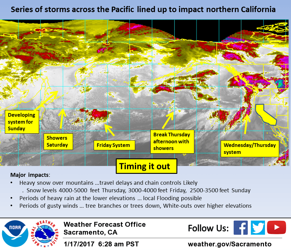
January 17, 2017 – Dry today, then a series of winter storms will begin Wednesday and continue into early next week. Current timing of storms is Wednesday night, Friday and Sunday. Each storm will bring gusty winds and heavy snow over the mountains.
Winter Storm Watch from Wednesday afternoon through Thursday morning for West Slope Northern Sierra Nevada-Western Plumas County/Lassen Park.
Discussion
Upper ridge over the west coast bringing fair skies to the CWA this morning. Exception is the central valley where fog has formed again. Most locations not showing as much fog as 24 hours ago but patchy dense fog may still be possible. Upper ridge begins to break down this afternoon as a Pacific frontal system approaches the coast.
Most areas of the forecast area will see increasing clouds today ahead of this system and non fog impacted areas will see cooler temperatures closer to normal. In areas where the fog clears more quickly today, temperatures may be a little warmer than yesterday.
Pacific front reaches the north coast tonight with light pre-frontal precipitation spreading over NorCal. Under warm air advection tonight, snow levels will remain moderately high but will lower slowly on Wednesday as the overall airmass cools.
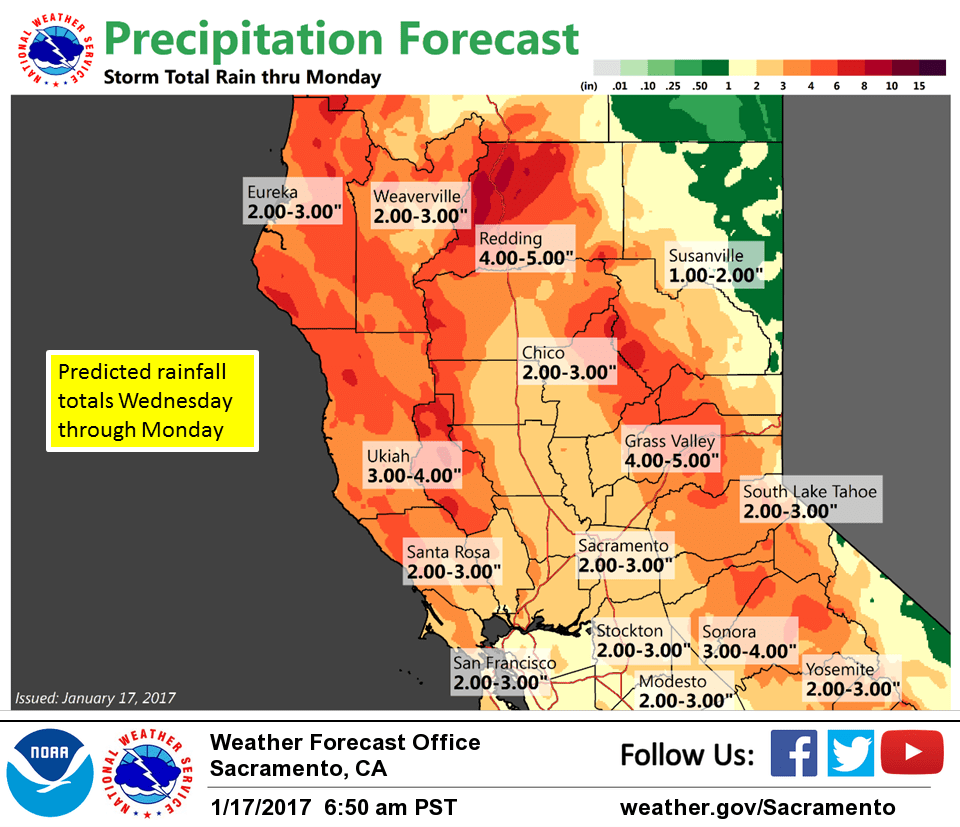
Light precipitation spreads southward on Wednesday covering most of the CWA by afternoon. Heavier precipitation then begins moving into the region late Wednesday afternoon and evening as the main frontal system pushes inland. This appears to be a moderately moist system with around .75 to 1.5 inches expected in the valley from mid day Wednesday to mid day Thursday with up to about 2 inches over the Sierra.
Gusty winds will accompany this system as well but exceptionally strong winds are not expected based on surface gradient progs.
Snow levels will likely start out too high to be impactful over the northern mountains early in the storm so heavier snowfall there will be limited to highest elevations.
The higher elevations of the Sierra will see much more snowfall and winter storm watch of heaviest precipitation period of mid day Wednesday to mid day Thursday looks good.
Should see a transition to showers Thursday afternoon as the frontal band shifts east of the state.
Next Pacific system moves in quickly on the heals of the Wednesday night storm pushing onto the coast Thursday night and into and across the state on Friday.
This is about 6 hours slower than previous model runs with main impact of this storm now hitting during the day on Friday. This system looks similar to the Wednesday night system on QPF amounts and winds but this will be a colder system with snow levels 3000 feet or lower through the day Friday and into Friday night. This should make for more significant impacts over the northern mountains and still cooler daytime temperatures.
Extended discussion (Saturday through Tuesday)
Weak upper ridging moves through Saturday with models suggesting lingering showers possible over the mountains. Precipitation then spreads across the area Saturday night into Sunday as next Pacific frontal system impacts interior NorCal.
Significant QPF expected as models showing upwards of 2+ inches in portions of the Central Valley Sunday through Monday with 3+ inches in the foothills and mountains. Snow possible down into the foothills with this system and several feet of new snow expected at pass levels impacting travel. Strong southerly winds forecast Sunday and wind advisories may be issued for portions of Interior NorCal. Decreasing showers Tuesday as weak high pressure returns to the forecast area.