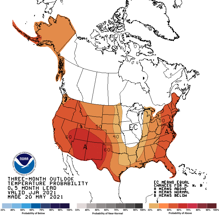
The Predictive Services 4-month outlook for the North Ops region calls for drier and warmer than average weather through September. There is some indication of a semi-regular low pressure trough positioned along the west coast much of the summer, which could lead to shorter stretches of intense dry heat. Fuels, both dead and live and of all size classes, are expected to dry to critical values earlier than usual at all elevations, leading to a start to the active fire season 4-6 weeks earlier than usual. At elevations below 3000 ft it is possible that the lighter than usual fine fuel crop will allow more successful initial attack efforts when ignitions occur through August. In areas dominated by timber, generally above 3000 ft, fuels will be vulnerable to fire spread, and any lightning will pose a threat of new large fires.

Significant Fire Potential for the North Ops region is Above Normal above 3000 ft from June through August, with the exception of areas near the coast (which may benefit from more onshore flow) and in the far east (where drought has led to less continuous fuels). The remainder of the region has Normal Significant Fire Potential during June-August. The Above Normal category will persist in the same areas in September, and lower elevations west of the crest are added due to the onset of N-NE/Offshore wind season combined with the persistent drought, despite the light fine fuel loading.
Normal Significant Fire Potential in June is defined as 2-2.5 large fires in the Sacramento Valley/Foothills and Far Eastside PSAs and up to 1.2 large fires elsewhere. In July Normal is defined as 1 large fire or less in coastal areas and 1.5-3 large fires inland. August typically is the peak of fire season, with near 1 large fire in the Bay Area PSAs and between 2.2 and 5.6 large fires per PSA elsewhere. In September Normal is defined as up to 1 large fire in the Bay Area PSAs and east of the crest and 1-3 large fires elsewhere.
June – September 2021 North Ops Highlights
- Very dry rainy season – more than half of the region was below 50% of average.
- Low elevation fine fuel crop at near to below normal fuel load, and mostly cured.
- Weak greenup underway above 3000′. Live fuel moisture peaking early at low values, and declining to critical levels as much as 4-6 weeks earlier than usual.
- Overall outlook is for drier and warmer than average from June – September. Near normal monsoon activity east, trending to less lightning than usual Coast Range.
- Significant Fire Potential Above Normal above 3000 ft elevations June-August, except along the coast and in eastern areas. Normal elsewhere.
- In Sept lower elevations W of the Cascade-Sierra crest join the Above Normal area due to critical dryness as offshore wind season begins, despite light fine fuel load.
Weather discussion

Precipitation was well below normal across the North Ops region in May. The rain year, which began on October 1st, is drier than average statewide. Most of the North Ops region received less than half of the normal precipitation. May was warmer than normal across much of the state. The main exception was in coastal areas which were influenced by nearby below normal sea surface temperatures.
The high elevation snow pack has melted off and drought conditions are worsening across the state) and the resulting weak snow melt runoff will end soon. The La Niña pattern, cooler than normal sea surface temps in the eastern tropical Pacific Ocean, has ended and neutral conditions are expected into the fall.
Although June is starting off hot and dry, periods of isolated to scattered mountain showers and thunderstorms can be expected as low pressure troughs occasionally move through the region through the 3rd week of the month.
Occasional light to moderate dry N-NE/Offshore wind events are expected into early July. This will lead to a higher potential of large fires. Some longer-range models show summer-time low pressure troughs along the west coast. This pattern would not produce much precipitation, but it could lead to more days with a deeper marine intrusion and shorter intense heat waves than usual.
The 4-month outlook calls for dry and warm weather. The summer monsoon and resulting lightning pattern is expected to be near normal in our eastern areas and affect our western areas less than usual.
Fuels discussion
The dry rainy season has led to widespread drought conditions throughout California. The months critical for growing the low elevation fine fuel crop, April and May, were very dry. The Evaporative Demand Drought Index, which quantifies the “thirst of the atmosphere” over a specified period, also shows intensifying drought conditions since late March, especially in southern and western areas. The dry spring led to normal or below normal fine fuel loading at lower elevations, and these annual grasses and weeds have now cured several weeks ahead of usual. Brush growth at lower elevations has also been very light, and the outer branches and twigs in some species may end up dying as the plants attempt to hold on to the limited moisture available. This process increases the flammability of the brush crop.
The 1000-hour dead fuel moisture averaged across the North Ops region shows near record values due to the very dry spring. The current values are equivalent to average values in the middle of July. Many stations are well into record territory in multiple indices. Middle and upper elevations are seeing a weak greenup among live fuels, and with the weak snow melt runoff, it is expected that these live fuels will see greenup peak at lower fuel moisture values than usual and decline to critical values weeks ahead of usual.
