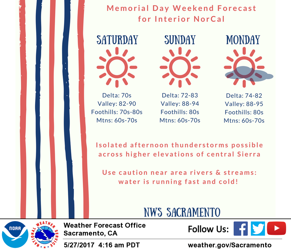
May 27, 2017 – Warming up this weekend. Isolated afternoon showers or thunderstorms possible over the central Sierra into early next week.
Discussion (Today through Monday)
Marine layer not as deep this morning (around 2000 feet) with stratus remaining mostly across the Bay area. Could see a few clouds into the Delta this morning, but not expecting a widespread intrusion like previous few mornings with weaker onshore flow.
Ridging will build across the area today into Sunday, resulting in warming temperatures. Highs today will top out near normal, in the 80s across the Valley, and 60s-70s in the mountains. An isolated thunderstorm is possible this afternoon/evening in the higher elevations of Tuolumne county, but forcing is limited so not expecting much.
Temperatures warm several degrees for Sunday with plenty of sunshine around. Again, cannot rule out an isolated PM thunderstorm across Tuolumne County but forcing remains weak. Ridging shifts off to the east for Memorial Day in advance of trough approaching the West Coast.
Models have trended cooler over past several runs for Monday and Tuesday and have nudged temperatures down again. Monday’s highs will be similar to Sunday’s readings.
As onshore flow increases by Tuesday, expect cooling trend to begin with Valley highs back down into the 80s. Better chances for PM thunderstorms across the mountains, but not expecting widespread activity at this time. Delta Breeze will also pick up on Tuesday with gusts to 35 mph and a more substantial cooldown across Solano County.
Extended discussion (Wednesday through Saturday)
An upper trough pushing on to the west coast Wednesday will bring more cooling with daytime highs expected to come in just a little above normal. GFS and ECMWF in fairly good agreement in bringing a chance of light showers to the northern most state in the morning and a chance of thunderstorms over the mountains in the afternoon and evening hours.
A second weaker shortwave is forecast to clip the north state on Thursday bringing a slight threat of thunderstorms over the Shasta county mountains. The rest of the forecast area will see generally fair skies and a little warmer temperatures. Model consistency drops towards the end of the week as models diverge on timing of next upstream shortwave system to move into the Pacific Northwest. GFS brings light precipitation to the far north state on Friday while ECMWF holds the precip farther north and a day later on Saturday.
For now, have kept the forecast area dry waiting for better consistency. Heights do climb a bit for Friday and Saturday so daytime temperatures warm a bit however, upper ridge over southwest U.S. will remain suppressed so temperatures should remain within about 10 degrees of normal.