Isolated mountain thunderstorms along and east of the Sierra Crest each afternoon and evening into the weekend. Otherwise quiet and warm weather continues.

Discussion
GOES-West infrared imagery reveals a few notable things this early Friday morning. For one, some high clouds over portions of central California leftover from yesterday’s afternoon/evening convection. Second, the hot spots in Siskiyou and Shasta Counties from the active wildfires. The two fires burning “hottest” tonight — according to satellite — are the Salt Fire and Lava Fires.
Temperatures overall are generally within several degrees of this time last night — widely ranging from the upper 50s to middle 60s in the vicinity of the Delta, to as warm as the upper 70s to near 80 in the northern Sacramento Valley and adjacent thermal belts. Marine layer offshore is slightly more compressed compared to this time yesterday, and combined with slightly weaker onshore gradients, the chances of a stratus sunrise surprise like yesterday for the Sacramento Metro Area is a bit lower (but not non-existent).
Main synoptic drivers for the western half of North America continue to be the anomalously strong ridge over the Canadian Prairies (was previously responsible for the record-breaking heat over the Pacific Northwest several days ago), as well as the high over the Desert Southwest. The clockwise flow around this Desert Southwest high will promote continued moisture advection north/northwest into portions of California and Nevada. For the northern Sierra, the best opportunity for afternoon showers/thunderstorms will generally be along and west of the Sierra crest.
The latest 3-km NAM brings slightly better shower/thunderstorm potential on Saturday to the northern Sierra, with the possibility of having some lingering convection into the overnight hours for the foothills and possibly parts of the Sacramento Valley. Probability remains low at this point, but something to keep an eye on.

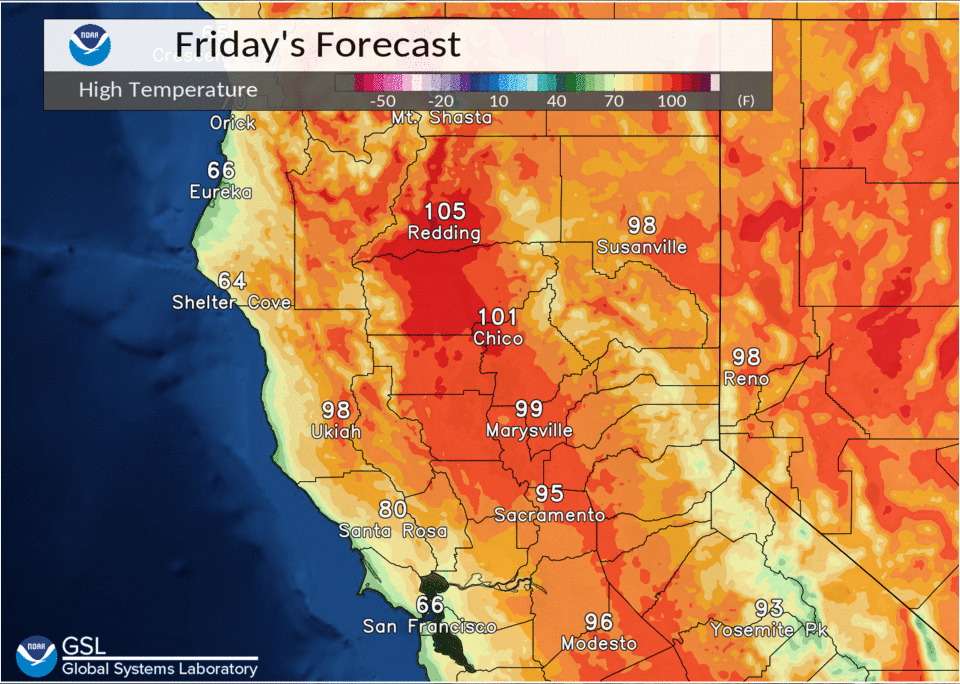
Shower/thunder chances for Independence Day and Monday will be largely limited to the crest and points east. Valley temperatures through the holiday weekend and into early next week will range from the upper 80s to 90s in the Delta, southern Sacramento Valley, and northern San Joaquin Valley, to the upper 90s to around 106 for the central and northern Sacramento Valley.
Extended discussion (Tuesday through Friday)
Upper high over the Desert SW continues to be main synoptic feature influencing weather over interior NorCal through the extended forecast period. This will result in dry conditions with above normal daytime temperatures. Triple digit highs will persist in the Northern Sacramento Valley and portions of the central part. Mid to upper 90s forecast elsewhere in the Central Valley with mainly upper 70s to lower 90s for the mountains and foothills.