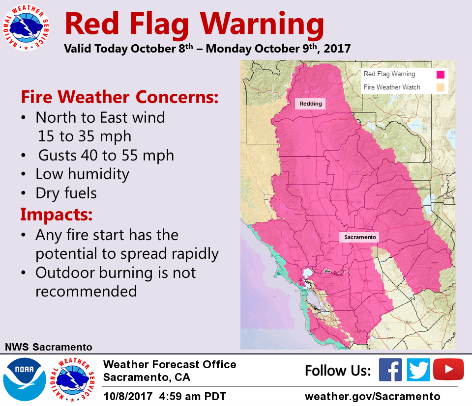
October 8, 2017 – Cooler and windy today into tonight with increased fire weather danger. Breezy Monday with near normal temperatures, then lighter wind with below normal temperatures by middle of the week. Red Flag Warning from 11 PM this evening to 5 PM Monday.
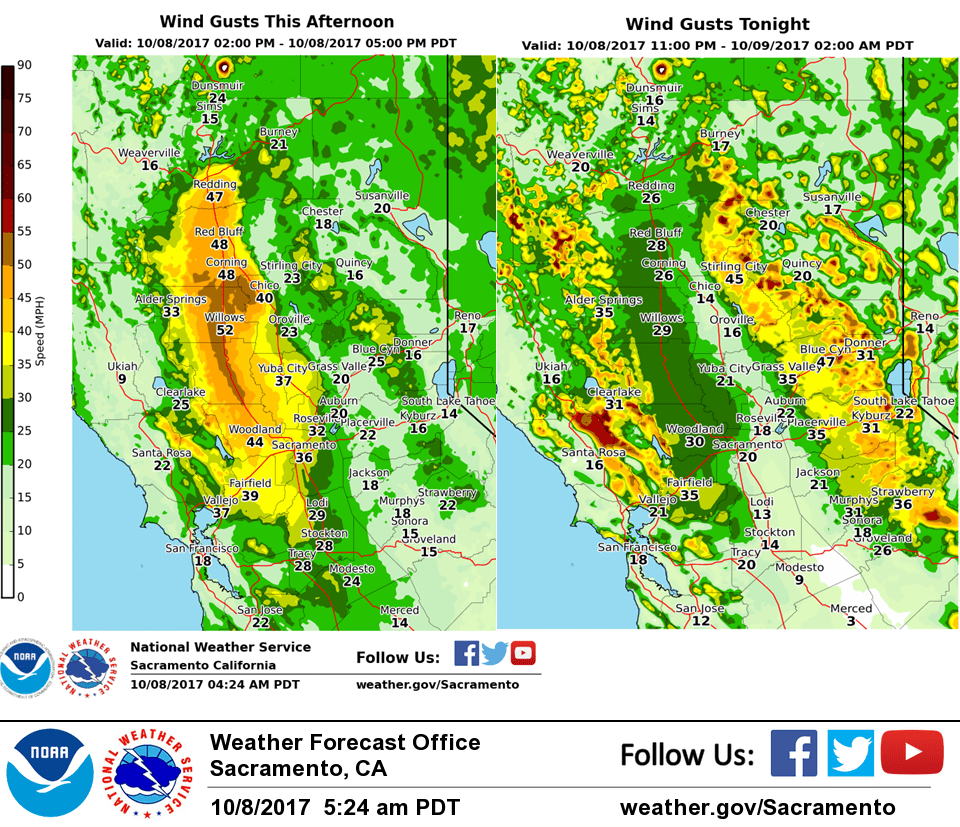
Wind Advisory from 7 PM this evening to 9 AM PDT Monday For the Central Valley, northerly wind of 15 to 35 mph is possible today with local gusts to 50 mph. Strongest wind expected along the west side of the Valley in the late morning and afternoon. In the mountains, wind will be strongest tonight with sustained wind speeds between 20 and 40 mph with local gusts up to 55 mph. Wind this strong can cause blowing debris and make driving difficult, especially for high profile vehicles. Secure loose objects that could be damaged by the wind, and use extra caution driving.
Discussion
Winds will continue to increase in the valley this morning peaking up north first and spreading south. Have extended the timing of the wind event slightly until 9 pm this evening for the valley. Winds over the west side of the valley look like they will take a little bit longer to settle down but will remain breezy overnight. Further north the winds look like they would stay up past midnight so have extended the advisory until 1 am. I have also started the advisory for the foothills and mountains an hour earlier at 7 pm. Southern Lake County looks like they will start to get stronger winds slightly earlier the other areas.
Upper ridging amplifying off the West Coast today as upper troughing digs into the Great Basin. EPAC surface high pressure is building into Oregon, and KMFR-KSAC surface pressure gradient is over 12 mb and rising. Mesowest data showing gusty wind above 2k feet attm. As radiative inversion breaks down this morning, stronger winds aloft will mix to the surface. This will result in windy conditions over much of Interior NorCal today. Wind advisory is in effect for the Central Valley from the Sacramento area northward. Strongest winds expected late morning and this afternoon where gusts up to 50 mph will be possible along the west side of the valley. Combination of gusty wind and low RH will lead to a period of increased fire danger today and Monday. In addition, synoptic cooling and low level CAA will result in high temperatures upwards of 10 degrees cooler today.
Surface high builds into the Great Basin tonight as inverted trough deepens along the CA coast. This will result in strong surface pressure gradient becoming NE-SW oriented which will focus stronger winds over the West slopes of the Sierra, Western Plumas and Coastal Range. Gusts up to 55 mph will be possibly through favorably oriented canyons tonight. Breezy conditions elsewhere will help to keep warmer minimum temperatures overnight.
Breezy wind continues over much of Interior NorCal Monday morning, but gradients look to weaken in the afternoon. Increased subsidence will result in slight warming tomorrow with Central Valley highs in the lower 80s. Drier AMS and lighter wind Monday night will allow for stronger radiative cooling with colder minimum temps Tuesday morning.
Flow aloft turns westerly Tuesday as upper trough in EPAC approaches the West Coast. Short wave progged to track across northern portions of the CA Tuesday night into Wednesday. Associated moisture with this system looks limited, and main impact for CWA appears to be increased onshore wind and cooling. Longer wavelength trough lingers along the West Coast through middle of the week resulting in below normal temperatures.
Extended discussion (Thursday through Sunday)
An upper low digging down the west coast on Thursday will bring continued cooler than normal temperatures and breezy north winds. Extended models are somewhat inconsistent in details of this system but it appears at this time that the best chance of any precipitation from it would be over the northern zones Friday. For now, have kept consistent with surrounding offices on precipitation threat but confidence remains low.
Models remain inconsistent going into next weekend but at this time, all appear to keep CWA free from precipitation as upper trough should shift inland.
General agreement is that there should be some sort of upper ridging next weekend for generally warmer daytime temperatures. Even with the warming, daytime highs are still likely to remain at least a little below normal.
This wind tonight grabbed my metal utility shed in the back yard, and tossed it 20 feet away! Darn…Next time it will be staked down! Lots of sirens right now (12:15am). I’m sure there’s going to be much grander stories than mine…