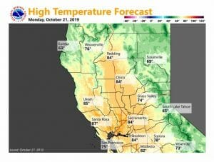
October 21, 2019 – Dry weather for at least the next week. Warmer than average for the remainder of this week. Breezy conditions at times, especially Wednesday into Thursday when elevated fire weather concerns are expected.
Discussion
Other than a few high clouds spilling over the eastern Pacific ridge, skies are clear across interior NorCal early this morning. Current temperatures range from the 30s in the mountain valleys to the 50s across the Central Valley and mountain thermal belts.
Warm and dry weather is expected this week as high pressure centered over the eastern Pacific extends into NorCal. A couple of bouts of breezy northerly winds are also expected. The first will occur today as surface gradients tighten and subsidence increases downstream of the upper ridge.
The second round of north winds is forecast for Wednesday into Thursday as gradients tighten in the wake of a short-wave trough that passes Tuesday night and early Wednesday.
Neither event looks particularly strong at this point as upper level support is lacking. However, the combination of the breezy to locally windy conditions with low relative humidity will elevate fire weather concerns once again.
High temperatures this week will be around 5-15 degrees above average.
Extended Discussion (Friday through Monday)
Upper level high pressure ridge is forecast to center over California on Friday bringing lighter pressure gradients and decreased winds. With maximum subsidence under the ridge, Friday is forecast to be generally the warmest day of the week although downslope effects earlier in the week may produce warmer temperatures in some locations.
A weather disturbance passing through the Pacific Northwest on Saturday will bring a few degrees of cooling most areas. Models are trending the upper trough as an inside slider moving from the Pacific Northwest into the northern Great Basin on Sunday then southward into the central Great Basin by Monday.
Northerly flow behind this system will bring cooler temperatures Sunday and Monday dropping daytime highs down to several degrees below normal.
Surface high pressure building into the Pacific Northwest behind this system will bring another round of moderate north winds to the CWA Sunday and Monday especially to the Sacramento valley and coast range. This wind and the drying expected to accompany it will mean another period of elevated fire concerns early next week.


