November 11, 2020 – Dry weather with below average temperatures continue today. The chance for rain and snow returns late in the week and into the weekend.

Discussion
Milder temperatures across much of the area early this morning as weak onshore flow is bringing coastal stratus inland into the southern half of the Sacramento Valley along with spreading higher dew points inland. Light northerly flow continues to draw drier air into the northern Sacramento Valley, and temperatures there this morning will likely be similar to Tuesday’s.
Northwest flow aloft will prevail through Thursday resulting in dry conditions. High temperatures will be around 3-8 degrees below average for mid-November. Overnight lows will remain chilly given the dry airmass and relatively cloud-free skies.

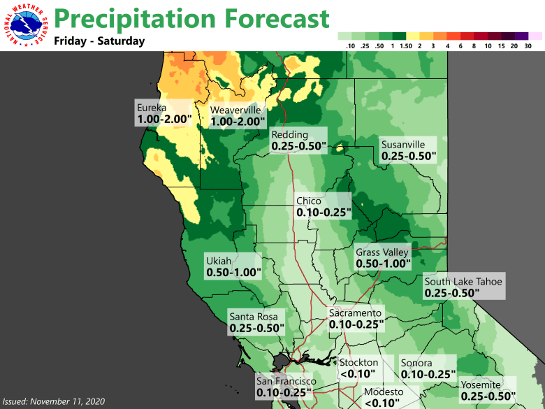
By late Thursday night, light precipitation will begin to develop from north to south as a storm system begins to impact northern California. Forecast models have been slowing the onset of the rain/snow over the past few model runs. Precipitation amounts are expected to remain generally light with this initial wave with locations south of I-80 not seeing much of anything for this first round.
Later on Friday evening and Friday night, cold front approaches northwest California and will be accompanied with the bulk of the moisture. Light to moderate rain and snow will spread north to south overnight and into Saturday.

Additionally, southerly winds will increase ahead of this front, becoming locally strong in the higher elevations as well as in portions of the Sacramento Valley.
Model trends have similarly backed off on total precipitation amounts, but impacts in the mountains are still expected nonetheless.
Extended discussion (Sunday through Wednesday)
Deterministic and ensemble models point to drier weather Sunday and Monday under upper level ridging, so have undercut NBM POPs. High temperatures warm to slightly above normal during this period.
Model differences exist with progression of next frontal system towards midweek. Forecast attm leans towards ECMWF solution which spreads widespread precipitation over the CWA PM Tuesday into Wednesday.

