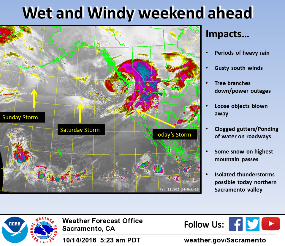
October 14, 2016 – A series of weather systems will bring periods of rain (heavy at times) and gusty winds through early next week.
Wind Advisory from 11 AM to 11 PM PDT Saturday for Burney Basin / Eastern Shasta County-Central Sacramento Valley-Mountains Southwestern Shasta County to Northern Lake County-Northeast Foothills/Sacramento Valley-Northern Sacramento Valley-Shasta Lake Area / Northern Shasta County-West Slope Northern Sierra Nevada-Western Plumas County/Lassen Park.
Discussion
First wave of the storm continues to push southward across the area early this afternoon. Rain is generally south of a line from Plumas County to Sacramento to the Bay Area. Moisture fizzled out a bit as system stalled near the coast overnight and then slowly pushed through the Valley this morning with lighter amounts than expected from Sacramento southward. But healthy totals recorded so far further north, generally from 1-3 inches across the northern Sierra and surrounding foothills. In the Valley, totals have ranged from around 1.5 inches in Redding to a few tenths near Sacramento. Behind main front, showers beginning to fire across Shasta and Tehama county. Latest hi-res guidance suggests this activity may continue into the evening hours. Recovery has been limited but enough instability present so can’t rule out a thunderstorm or two up in that area.
A few showers may linger across higher elevations overnight but most areas should see a bit of a break before next wave approaches. Latest guidance in fairly good agreement that next batch of rain will begin to move into NW California Saturday afternoon and push southward across the area into Sunday. There might be a good deal of shadowing across the Valley which could limit accumulations totals. Additional totals through early Monday will be up to 1 inch in the Valley and another 4 to 7 inches across the mountains. Winds will pick up again Saturday afternoon into early Sunday with gusts of 30 to 50 mph across northern and central Sac Valley and mountains. Wind advisory remains in effect. Much like the first wave, could see some downed tree limbs and power outages across the area. Main change to going forecast was the addition of thunderstorms across northern Sac Valley on Sunday afternoon. Models showing decent instability with favorable shear profiles in this area.
Snow levels will be fairly high above pass levels into Sunday but could drop to around 7000-7500 feet in heavier showers during the day Sunday. This may bring a dusting of snow near pass levels, but majority of accumulation should be in liquid form. Higher peaks like Lassen and near the Sierra crest will receive more. Precipitation will taper off Sunday night with a few showers lingering over northern portions of the state on Monday. Drying out elsewhere.
Extended discussion (Tuesday through Friday)
Except for some lingering light showers over Shasta County on Tuesday morning/afternoon, high pressure will bring dry and warmer weather through the extended forecast period. Valley highs on Tuesday will be in the low 70s then reach the upper 70s on Wednesday, upper 70s to low 80s on Thursday and Friday.