October 27, 2016 – Wet and unsettled weather into early next week as several weather systems move across the area.
Discussion
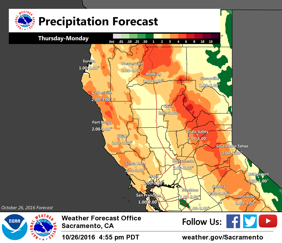
Some light rain beginning to spread inland across interior NorCal early this morning as the frontal system slowly works inland. Temperatures are very mild across the region, generally in the 50s to lower 60s.
Mostly light rain along with breezy conditions are expected across the area today as the front slowly shifts east and deep moisture continues to feed up from the southwest (TPW in excess of 1.25 inches). Orographic enhancement will lead to higher amounts over the northern Sierra and mountains north of Redding.
Heavier rain expected to arrive tonight into midday Friday as the wave currently to the southwest of 30N/130W approaches bringing stronger lift to the very moist airmass (some of it originating from Hurricane Seymour). Amounts in excess of an inch will be possible across the northern San Joaquin Valley and southern half of the Sacramento Valley by midday Friday while portions of the northern Sierra may see 2-4 inches. Snow levels will be very high with no impact to travel expected.
Moist southwest flow will continue precipitation chances across the area into Saturday, especially in the northern Sierra. Saturday night and Sunday another stronger system will move through the region with gusty winds and more heavy precip. Snow levels will be lowering with snow potentially impacting travel through the northern Sierra passes.
Extended discussion (Monday through Thursday)
GFS/ECMWF-Hi Res similar in progressing mid latitude extra- tropical cyclone towards California Monday and tracking it through Tuesday. Models do however differ significantly with depth of system and exact track. GEM shows a wave much farther north and moves it through about 24 hours sooner. Models then bring another Pacific system inland Wednesday but again differ with strength and track. GEM/EURO keep bulk of precip north of I-80 with GFS showing more widespread precip and higher QPF. Thus uncertainties exist through the extended forecast period. Main theme however is periods of precipitation possible with below normal temperatures. Models suggest a break in the precip Thursday under weak ridging.