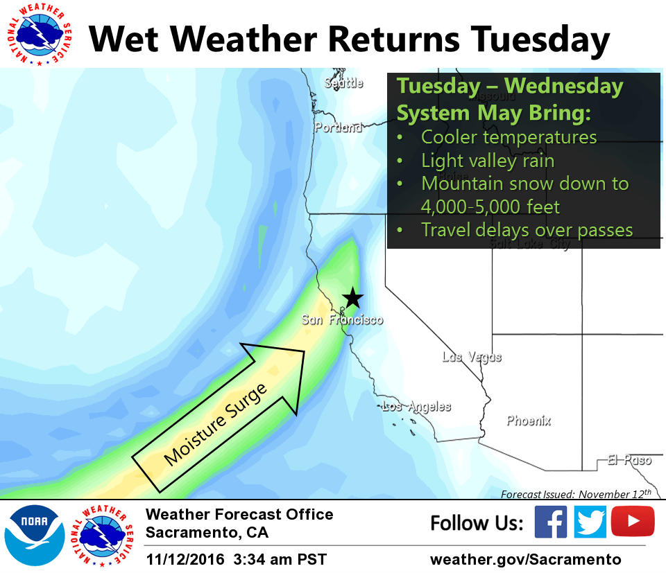
November 12, 2016 – A weak system will bring scattered showers for northern portions of the state today. Dry weather for Sunday through Monday night. A stronger system will bring more widespread rain and mountain snow to the area later Tuesday into Wednesday.
Short Term Discussion
Weak trough currently moving inland early this morning with broad area of high pressure off to the east. Cloud cover overnight over much of the area will likely preclude the formation of widespread fog toward daybreak. Cannot rule out a few patches here or there, mainly across the San Joaquin Valley and southern Sac valley, but shouldn’t have a large impact.
Radar shows a narrow band of precipitation associated with the trough currently moving into northwestern portions of the area (mainly north of Red Bluff). Accumulations to the east have been light so far, generally a tenth to a quarter of an inch. Latest hi- res guidance isn’t overly impressive with precip chances as trough moves east today.
Light accumulations are possible north of a Lakeport to Downieville line through this afternoon, but activity will be highly scattered. Dry weather continues elsewhere. Highs today should top out a few degrees cooler than Friday.
Trough lifts to the north on Sunday with ridging building in for the start of the week. A few shortwaves will ride east in the flow but should keep any precipitation to the north of the area through Monday.
Another trough will approach the area by Tuesday with precipitation maybe reaching NW corner by Tuesday afternoon. Area of showers will spread southeast through the evening and overnight hours. Latest model runs have backed off a bit on precipitation amounts with the system with heaviest amounts expected across the mountains. Snow levels Tuesday will initially start high above 10,000 feet but drop rapidly as associated front moves through. Details follow in extended discussion.
Extended discussion (Wednesday through Saturday)
A frontal band forecast to pass through Norcal Tuesday night should be east of the state by Wednesday morning. Upper troughing will then slide over the north state during the day Wednesday. This trough is forecast to generate showers over most of the forecast area during the day.
Snow levels in the cold air behind the front will drop down to around 5000 feet over the northern Sierra. Precipitation with this trough is not expected to be heavy but could see on the order of 2 to several inches of snowfall above 5000 feet on Wednesday or enough to cause some travel difficulties.
An upper ridge should begin re-amplifying over the west coast Wednesday night with an end to any residual showers likely by Thursday.
At this time, Thursday and Friday look dry under the ridge with temperatures warming each day but highs on Friday are still expected to come in a little below normal.
Models in fairly good agreement in bringing another Pacific storm system onto the coast around the middle of next weekend. Timing varies a bit between models but overall, model consistency this far our is actually not too bad. Under current model solutions, precipitation sometime next weekend looks like a pretty good bet.