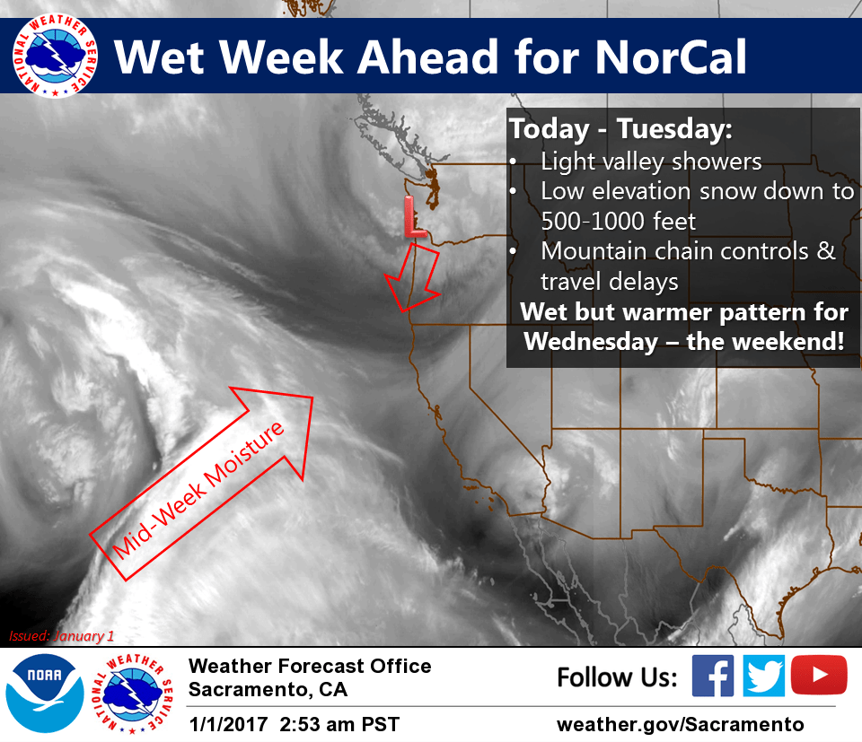
January 1, 2017 – Colder systems will move in today and continue into Tuesday with snow levels possibly dropping down into the foothills and northern Sac Valley. Wet but warmer pattern for mid-week into next weekend.
Winter Weather Advisory from 10 AM this morning to 10 PM PST Tuesday for Burney Basin / Eastern Shasta County-Clear Lake/Southern Lake County-Mountains Southwestern Shasta County to Northern Lake County-Shasta Lake Area / Northern Shasta County-West Slope Northern Sierra Nevada-Western Plumas County/Lassen Park.
Discussion
Upper level system currently dropping south through the Pacific Northwest will usher in the beginning of a wet week for NorCal. Showers will overspread the area during the afternoon and evening hours today and continue into Tuesday. Precipitation with this first wave today and Monday will be more showery and likely contained to the mountains for the most part, although a few showers possible in the Valley from time to time.
Colder air will filter in which will drop snow levels as low as 500 to 1000 feet in Shasta county and to around 1000 feet for the Coastal range and western slopes of the Sierra. Going forecast largely still intact through late Monday with only slight tweaks to precipitation amounts and snow levels.
Models have come in a bit warmer for Tuesday so have nudged snow levels up slightly but think cold air may be a little slow to overcome. The I-5 corridor through Shasta County could peak at 1 to 2 feet of new snow above 1000 feet through Tuesday. Could even see a dusting into the Redding area.
For the eastern slopes of the Coastal Range and western slopes of the Sierra, a light dusting of snow possible around 1000 feet, but the peak snow accumulations of 6-18 inches will be above 3000 feet. Winter weather advisory remains.
Model differences for later Tuesday into Wednesday lead to a lower confidence forecast for the end of the period. GFS has a brief break in the precip for most of the area Tuesday afternoon into early Wednesday while ECMWF and GEM keep the moisture flowing into the area all the way through. Regardless, additional accumulations likely with snow levels a bit higher in the 3000 to 5000 foot range. Mountain travel will continue to be impacted and additional winter weather products will probably be needed past Tuesday.
Rain amounts in the valley from Sunday thru Tuesday will be light south of I-80, up to a quarter of an inch with higher amounts up to three-quarters of an inch north of I-80. Additional amounts of 0.5 to 1 inch possible on Wednesday depending on how model solutions fare in the next few days.
As mentioned by previous shifts, overnight lows have trended warmer given wetter and warmer pattern, thus hard freeze potential virtually nil with valley lows in the mid 30s to low 40s.
Extended discussion (Thursday through Sunday)

Latest model runs have continued the trend toward wetter and milder weather for later this week, though there is still some discrepancy Thursday and Friday on how far west the closed low will retrograde off the coast. The GFS continues to indicate heavier orographic precipitation over the northern Sierra while the EC and GEM indicate more of a break in the precipitation with just some lingering showers.
There’s better agreement over the weekend where all the models suggest another wet system impacting NorCal.