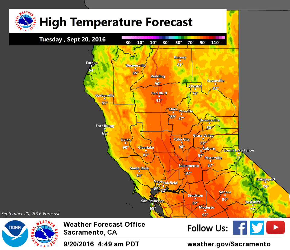
September 20, 2016 – Cooling trend with a slight chance of Sierra showers and storms mid-week. Warming and drying trend by the weekend.
Discussion
Clear to partly cloudy skies cover interior NorCal early this morning. Water vapor satellite imagery shows that the strong ridge of the past several days is beginning to get nudged eastward as the deep trough over the PacNW begins to pivot this direction. However, we’ve yet to see much effect as most areas are still running several degrees warmer compared to 24 hours ago.
Significant changes forecast to begin today across Norcal as the PacNW low moves our direction. The result will be a dramatic cool down for the region along with gusty southwest winds. By Thursday, max temps will be some 20-30 degrees cooler than on Monday, just in time for the start of fall (autumnal equinox is Sept 22 at 721 AM PDT). But this will be an “autumn tease” as high pressure returns by the end of the week and warms temps up once again.
The digging trof will send the upper level front across NorCal today before stalling out south of I-80. The trof will be mainly dry for the Valley with showers mainly concentrated near the low center over the far northern portion of Norcal Wednesday night and Thursday.
Deeper moisture moving up from the south ahead of the system bears watching for potential interaction with the initial front resulting in shower potential along and south of I-80 later tonight and early Wednesday.
In addition, the trof will bring an increase in the Delta Breeze along with breezy ridge tops winds. Fortunately, the cooler temps will also mean some increase in RHs for our mtns. Any showers over the mountains could bring some snow as snow levels fall to about 6500-7500 from N to S and around 7 kft along the I-80 corridor on Thursday when the upper low and trof moves over the region.
Extended discussion (Saturday through Tuesday)
High pressure over the Eastern Pacific Ocean will bring warm and dry weather to our region during the extended forecast. The high will move closer to the coast by Sunday and daytime highs for Saturday and Sunday will range 4-10 degrees above normal. Periods of breezy conditions this weekend…especially over higher terrain and on the western side of the Sacramento Valley this weekend. The high weakens Monday and Tuesday but still lingers over NorCal. Daytime highs will cool slightly but still be several degrees above normal.