Warm and dry weather continue through the middle of next week. A slight chance of thunderstorms possible over the mountains late next week.
Discussion
Another hot day across interior NorCal with temps currently trending a few degrees warmer than 24 hours ago. Marine layer remains squished – less than 1K feet deep. Will evaluate thunderstorm potential for the northern mountains Sunday evening with strong short-wave moving through.
Strong high pressure remains in control over California with just a few high cirrus clouds riding over the top of the ridge. The ridge has helped compress the marine layer, now running at less than 1000 ft deep along the coast at Fort Ord. Temperatures across Northern California are running a few degrees warmer than 24 hours ago.
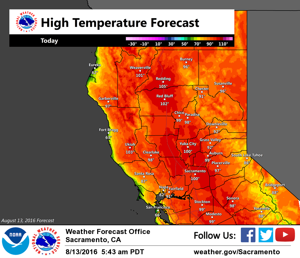
High pressure remains in control today and will result in another hot afternoon across the interior. Expect high temperatures in the upper 90s to around 105 degrees across the Valley today, with 80s to 90s over the mountains. These forecast highs are 5 to 10 degrees warmer than normal.
A shortwave trough from the central Pacific then moves inland over Northern California on Sunday. At the very least, this system should bring cooling of a few degrees across the region. Computer models have been trending more unstable with this system, primarily along the Trinity Alps. Have left the forecast dry for our forecast area for now, but will continue to watch trends to see if we’ll need to add a chance for thunderstorms over the Shasta mountains for Sunday.
A second, weaker and drier shortwave moves across California Monday into Tuesday. All in all, temperatures are expected to remain warmer than normal through the short-term period.
Extended discussion (Wednesday through Saturday)
Mid range models showing very weak troughing over the west coast next Wednesday but at this time forcing looks too weak to generate any shower or thunderstorm activity. In fact, daytime highs expected to continue to be on the order of several degrees above normal.
Models hint at the development of a weak low somewhere along the central coast by next Thursday. Southeast flow around the low over the northern Sierra could start to bring up enough monsoon moisture for a threat of thunderstorms over the northern Sierra crest Thursday afternoon or evening. Otherwise, Thursday will see a slight cooling although highs will still remain a few to several degrees above normal. GFS shows continued southeast flow over the Sierra on Friday for continued thunderstorm threat but ECMWF and GEM indicate a more westerly flow aloft and less of a Sierra convective threat. Due to uncertainty, have toned down mountain thunderstorm threat Friday and limited chances to the Sierra Cascade crest. This uncertainty continues into Saturday so went with the same approach for the end of the extended period as well limiting afternoon or evening thunderstorm threat to the Sierra Cascade crest. Friday and Saturday should see a little cooling under a slightly cooler airmass but daily highs are still expected to top normal for this time of year.