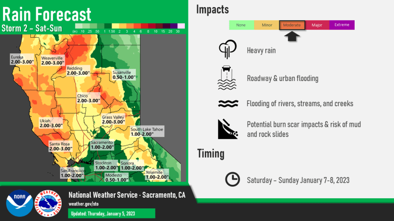
A series of strong storms will move across the region into next week. The current storm will continue to weaken today, but additional strong storms are expected over the weekend and again early next week bringing moderate to heavy rain, high elevations snow, and gusty winds. Heavy precipitation will keep flooding threats elevated and mountain travel impacts at the forefront into next week.

Discussion
The brunt of the current system has moved through with the peak in winds and rain now behind us. However, showery and breezy weather will continue today in the post-frontal airmass.

Several additional lines of showers with a few embedded thunderstorms are likely before the upper trough finally swings through later this afternoon or early this evening.

Surface pressure gradient has begun to relax, but it will remain breezy throughout the day with gusts of 40-50 mph possibly lingering much of the day across the northern Sacramento Valley. The High Wind Warning will be lowered shortly with a wind advisory until early afternoon for the north end of the Sacramento Valley.

In the Sierra, traffic cams show heavy snow currently across the passes, Snow levels will lower somewhat through the day and overnight tonight. Travel impacts will be severe with 1-2 ft of additional snow likely across the passes during the next 24 hours.
Runoff from the ongoing precipitation will bring renewed rises to are creeks, streams and rivers. A Flood Watch remains in effect for much of the region.
Short wave ridging builds in tonight into Friday and that will bring a short break from the active weather for most of the region, though renewed warm-advection will continue precipitation chances north of Interstate 80.

Widespread rain and high-elevation snow returns Saturday with another period of moderate to heavy rain into Sunday.

Snow levels will be 4500-5500 feet and significant mountain travel impacts can be expected.
Southerly winds will also increase but likely won’t be as strong as the current system.
Extended Discussion (Monday through Thursday)

Wet and stormy pattern likely to continue for NorCal next week as storms continue to move across the Pacific into the region. Currently, it’s still looking like Monday will see another strong AR bring widespread moderate to heavy rain, strong southerly winds, and heavy snow to the higher elevations.

The cumulative effects of repeated rounds of moderate to heavy rain from preceding storms may lead to higher potential for more widespread flooding with increasingly severe impacts with this storm.
Following Monday’s storm, there are signs that precipitation may slow down for a day or so into the middle of next week before another moderate to strong AR moves in Thursday. Stay tuned!
