Weak weather system will bring light rain and snow to portions of northern Sacramento Valley today. Stronger, more impactful storms will move through Wednesday through next weekend. Strongest storms are expected Wednesday through Thursday and again over the weekend. Widespread strong winds are expected Wednesday into Thursday. All this precipitation will keep flooding threats elevated and mountain travel impacts at the forefront for the rest of the week into the weekend. Winter Storm Warning from 7 AM Wednesday to 4 AM PST Friday. Flood Watch from Wednesday morning through Friday morning. High Wind Watch from Wednesday morning through Thursday afternoon.

Discussion
The shortwave responsible for Monday’s wet weather is currently lifting northeast. Some lingering light showers will be possible on the backside of the shortwave where there’s added upslope flow. Lingering showers should dissipate by sunrise.
Another weak shortwave will be brushing across NorCal later today, with limited moisture, only expecting some sprinkles across portions central to northern Sacramento Valley with ‘better’ precipitation amounts across far northwestern Shasta County where there’s 50-60% chances. Overall, today’s weak system will produce little to no impacts.
A more potent weather system is forecast to impact NorCal early morning Wednesday and continues through Thursday night which will bring very strong winds, heavy rain and mountain snow.
This storm taps into a moderate to strong Atmospheric River (AR). Therefore, another round of moderate to heavy precipitation is expected with more flooding concerns.

Precipitation forecasts for the midweek storm continue to be around 2 to 3 inches possible in the Central Valley with 3 to 6 inches or more of liquid precip in the foothills and mountains.
Based on latest guidance, a band of precipitation will move up from the southwest early morning Wednesday, with widespread rainfall expected for the morning commute. The heaviest rainfall is expected to be Wednesday afternoon and overnight.

With already saturated soils, and rivers, creeks and streams already running high from the end of the year’s heavy precipitation, additional heavy rain will likely lead to additional flooding concerns. Minor to moderate flooding is possible on area rivers and streams, as well as urban flooding. As such, a Flood Watch was issued, and will be in effect early Wednesday through Friday morning.
Even though rainfall will be winding down Friday morning, flooding impacts can remain several hours (and even days) after the heaviest rainfall occurred.

Reminder, if you encounter flooded roadways, Turn Around, Don’t Drown! Be sure to be extra cautious when driving at night, when it may be difficult to see flooded roadways.

Snow levels start out around 3-4k ft early Wednesday, quickly rising to around 5-7k ft by early Wednesday evening, then dropping back down to around 5-5.5k ft Thursday.
Even with fluctuating snow levels, the majority of the snow is expected above 5,000 feet. Though, it’s important to note that snow levels associated with AR’s can be tricky, resulting in either higher or lower snow levels at times.
If driving along roadways between 4000-6000 feet, be prepared for both heavy rain and/or heavy snowfall. With heavier precipitation expected, more mountain travel impacts are likely, with 1 to 3 feet of mountain snow.

The Winter Storm Watch was upgraded to a Winter Storm Warning for elevations above 5,000 feet from early Wednesday through overnight Thursday.

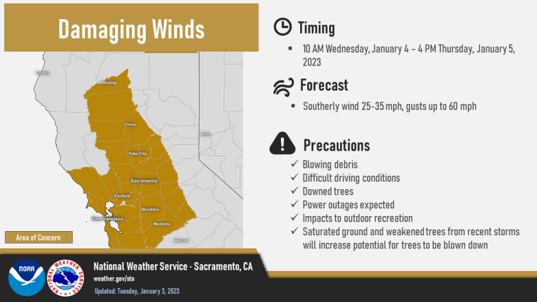
In addition to moderate to heavy precipitation mid- week, a strong low-level jet will also create strong southerly winds across the region. Wind gusts are forecast 40-60 mph in the Valley and foothills, with gusts up to 65+ mph in the mountains. Still some uncertainty in the timing and magnitude of the strongest winds, but the latest forecast has the peak winds occurring Wednesday afternoon through early Thursday.

Regardless, already saturated soils plus strong southerly winds for a longer period of time will likely result in downed trees and possible widespread power outages. So prepare now for all the possible hazardous with this midweek system!
By Thursday evening, the AR moisture will lessen as it shifts southward. Additional weak waves will keep precip chances in the forecast through Friday.
Extended Discussion (Saturday through Tuesday)

Wet weather continues through the extended forecast period as models indicate additional Pacific storms moving through but differ with timing and QPF. CW3E AR Landfall tool points to multiple ARs with the strongest early next week.

Potential for significant flooding issues as snow levels rise through the extended period and run-off intensifies on saturated soils.
