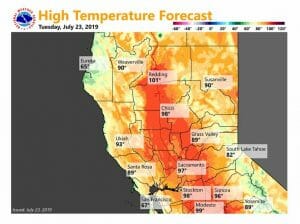
July 23, 2019 – Hot temperatures this week with widespread temperatures near 100 degrees. There is a slight chance of thunderstorms over the Central Sierra late this week, though they will likely remain east and south of our forecast area.
Discussion
Clear skies cover most of interior NorCal early this morning, though satellite imagery shows another batch of mid and high clouds moving north from central California ahead of another vort moving up in the southerly flow. Current temperatures are in the upper 40s and 50s in the mountain valleys, and in the 60s and 70s across the Central Valley (coolest near the Delta).
Hot weather will continue across the region through the remainder of the week as high pressure over the Desert Southwest gradually extends north and west. Highs today will be similar to Monday`s readings, though temperatures may be down a bit in the areas influenced by the Delta Breeze as a short-wave moving through the PacNW induces stronger onshore flow.
Highs through much of the Central Valley on Wednesday thru Friday are forecast to range from 100-105 with Delta Breeze influenced areas expected to be a bit cooler Thursday and Friday as the breeze returns. Overnight lows will be mainly in the 60s to lower 70s helping to mitigate widespread heat impacts.
Axis of deeper moisture and instability is expected to remain mostly to the south and east of the area through the remainder of the week, though a few late-day thunderstorms may approach the southeast corner of the forecast area on Thursday.
Extended Discussion (Saturday through Tuesday)
High pressure ridging shifts over the west coast going into the weekend Saturday bringing a little warming most areas. Subsidence under the ridge should mean minimal convection. Mainly clear skies are in store with just a little bit of warming from earlier in the week.
During this climatological warmest period of the year, highs Saturday are forecast to be several degrees above normal but still several degrees below record territory. Little change is expected Sunday with just a bit more warming as the ridging amplifies.
Forecast models shift the upper ridge eastward on Monday as a weak trough develops over the western Pacific. This will bring a little cooling while stable southwest flow aloft keeps any precipitation out of the forecast.
Still more cooling is expected next Tuesday as the upper trough digs in along the coast with daytime highs back down to near normal at the end of the extended period.


