Happening Now brings community news, updates and announcements throughout the day. You are invited to participate. See a road closure? A smoke plume? Weather-related mishap? Email us at news@yubanet.com or call 530-478-9600. Or text 530-409-9888, but please don’t text or call while driving.
September 30, 2020 at 4:06 PM Dozer line is almost completed around the Colleen fire, releasing tanker 89 and Air Attack 230 back to Grass Valley.
September 30, 2020 at 3:56 PM Air Attack is releasing Tanker 93 back to Chico from the Colleen incident. Helicopter 205 is released back to Auburn.
September 30, 2020 at 3:53 PM Air Attack of the incident on the Colleen Fire reports 3 acres, with the rate of spread having slowed substantially. Firefighters are making good progress.

September 30, 2020 at 3:31 PM Reported vegetation fire in Loma Rica, Yuba County. Reported as a 100 ft grass fire on Colleen Court, Units en route or arriving at scene.
September 30, 2020 at 11:56 AM Watch the Yuba River town hall live.
September 30, 2020 at 11:47 AM Car fire on Dry Creek Road at Christian Valley in Auburn, units are at scene.
September 30, 2020 at 10:33 AM Non-injury accident on southbound Hwy 49 at Combie. Three cars, one of them a tow truck, involved. Roadway is clear.
September 30, 2020 at 10:24 AM Report of a possible accident (heard only) on Brunswick Road and Beaver Drive. Units are en route.
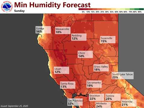
September 30, 2020 at 8:46 AM Moderate Heat Risk through Friday, continued smoke and haze. Above average temperatures and moderate to high heat risk expected for portions of the Valley and foothills through Friday. High temperatures will be anywhere from 10 to 15 degrees above normal, with the hottest days expected today and tomorrow. A small area of high heat risk is possible near the Delta these days, although wildfire smoke near that area may decrease highs if it becomes dense. A period of breezy east winds will be possible in the Sierra and surrounding foothills tonight into Thursday morning, along with some breezy Valley winds this afternoon in the Southern Sacramento Valley and Northern San Joaquin Valley. Temperatures remain slightly above average this weekend and dry weather looks to continue.
September 29, 2020 at 8:54 PM
September 29, 2020 at 5:46 PM Small fire above the town of Washington, Cherry Hill. Resources on scene, no threat to structures or infrastructure. Tahoe National Forest AA-17 TNF BC-31 E-333 WT-32 assigned. The forward progress is stopped.
September 29, 2020 at 10:45 AM Smoke is making a comeback with changing wind patterns.

September 29, 2020 at 10:37 AM Motorcycle accident on Hwy 20 at the White Cloud campground. Patient is being transported to Sierra Nevada Memorial Hospital.
September 29, 2020 at 9:22 AM Solo vehicle off the roadway on Purdon Road near Montezuma, about 15 ft down a steep embankment, no driver in sight. Emergency services are at at scene.
September 29, 2020 at 7:20 AM
September 29, 2020 at 7:06 AM Well above normal temperatures and dry conditions persist. Strong high pressure will bring a return of summer-like heat and moderate heat risk to interior NorCal during the middle of the week.
September 28, 2020 at 12:01 PM Canceling all incoming resources with the exception of 2 engines and one water tender.
September 28, 2020 at 11:47 AM Reported vegetation fire on Robinson Mill Road across of Blacktail Road in Butte County. Full wildland dispatch on order.
September 28, 2020 at 11:28 AM Early this morning Peardale Chicago Park Fire sent Brush-57 as part of the 4106-C Strike Team assigned to the August Complex.
Other Engines in the strike team are coming from the following departments:
-Ophir Hill Fire
-Nevada County Consolidated Fire
-Rough and Ready Fire
-Nevada City Fire
Strike Team Leader, from Ophir Hill Fire.
Strike Team Leader Trainee from Penn Valley Fire.
Thanks to Peardale Chicago Park Fire PIO Danial Ramey for the photo. Stay safe!

September 28, 2020 at 8:05 AM Red Flag Warning until 9 pm tonight. Dry, windy, and hot conditions will lead to critical fire weather conditions through today. Above normal temperatures and dry conditions will linger through the second half of the week.
September 28, 2020 at 3:00 AM Cruzon IC reports the fire is contained.
September 28, 2020 at 2:16 AM Updates on the Cruzon Fire will be posted here: https://yubanet.com/regional-fires/cruzon-2/
September 28, 2020 at 2:12 AM Units have located at fire, approximately 5 acres, burning at a slow rate of spread. This will be the Cruzon incident. Difficult access to the incident.
September 28, 2020 at 2:10 AM Units in the area are still unable to locate a fire, water tender to stage at Cruzon and Bear Trap Springs.
September 28, 2020 at 2:02 AM Reporting party has called back with additional directions to the fire, off Bear Trap Springs and a Forest Service Road, units are in the area.
September 28, 2020 at 1:58 AM Units on Bear Trap Springs are unable to locate a fire, they are continuing to search on Bear Trap.
September 28, 2020 at 1:45 AM Reported fire on Cruzon Grade near Bear Trap Springs above Malakoff Diggins, numerous units en route. Trees on fire near the water hole, per the initial report.
September 28, 2020 at 12:22 AM Tree down on northbound Hwy 49 at McKnight, one lane partially blocked.
September 27, 2020 at 10:26 AM Critical to locally extreme fire weather and hot temperatures this week. Strong north and east winds have developed across much of the area this morning and we will see these continue at least into the early part of the afternoon before they let up some. Winds will pick up once again over the Sierra and Foothills tonight and will be similar to a bit stronger than what they were last night and this morning. Winds will begin to diminish during the morning Monday but will remain breezy into the afternoon. Low daytime humidity and poor to moderate overnight humidity recoveries will accompany these winds. This will bring critical to locally extreme fire weather conditions into Monday afternoon. High pressure building into the region will continue to bring warming temperatures and we will see them push into the 90s to near 100 for the Valley and Foothills today and for much of this week. The changing wind direction and heat will likely bring the return of smoke impacts to much of the region, you can monitor air quality at fire.airnow.gov.
September 26, 2020 at 11:31 PM Fatal accident on westbound Hwy 49 at Dorsey Drive.
September 26, 2020 at 6:50 PM Nevada City BLM vigil.

September 26, 2020 at 3:00 PM
September 26, 2020 at 2:43 PM Reported vegetation fire in the Loma Rica/Marysville area, emergency services en route.
September 26, 2020 at 2:31 PM The Red Flag Warning is now in effect from 9 Pm this evening to 9 pm Monday.
September 26, 2020 at 11:20 AM The haze in the air and the smell of smoke are from the 304,881-acre North Complex fires. The shifting winds not only bring us a Red Flag Warning, but also deteriorate the air quality.
September 26, 2020 at 5:09 AM Extreme Fire Weather Conditions Sept 26-28. Strong winds will develop late Saturday night through Monday morning. Strong wind gusts from 30-45 mph are likely, locally up to 55 over the foothills & mountains. The strongest winds will be over the Central Sacramento Valley and the Sierra foothills. A Red Flag Warning is in effect for much of interior NorCal from 9pm Saturday – Monday afternoon. Gusty north to east winds & extremely dry conditions will create EXTREME fire weather conditions.
September 26, 2020 at 4:28 AM The small spot fires are extinguished.
September 26, 2020 at 4:13 AM North San Juan and CAL FIRE units at scene of 4 small spot fires near the road on Tyler Foote Crossing Road and Badger Hill Road, across from the clinic.
September 25, 2020 at 10:01 PM NWS Sacramento: Video Briefing for Extreme Fire Weather Conditions Sept 26-28
September 25, 2020 at 9:02 PM
September 25, 2020 at 8:50 PM The Red Flag Warning has been extended to 2:00 pm Monday.
September 25, 2020 at 6:26 PM A message from Erin Minett, Mayor City of Nevada City:
The Coalition for Racial Justice is hosting a Black Lives Matter vigil for remembrance, peace & action tomorrow Saturday September 26th at 5pm. The vigil will be held at Robinson’s Plaza, downtown Nevada City, located at the corner of Commercial & Union Street. Attendees are encouraged to bring flameless candles, flowers, photos, art, or posters that represent our fallen angels.
In the past, Nevada City has never worried about a rally or a march. Today we want to be alert and careful. We want the public to be informed and safe. Our City and is taking all precautions. We expect a peaceful event where violence will not be tolerated.
Erin Minett Mayor of Nevada City.
September 25, 2020 at 4:12 PM PSPS #2 maps have been updated. 96,878 customers in 16 counties could be potentially impacted.
September 25, 2020 at 3:14 PM Overturned vehicle on Hwy 49 near Oregon Creek. Parties are out of the car, emergency services en route.
September 25, 2020 at 2:03 PM Car towing another vehicle that is missing a tire on Purdon Road near Tyler Foote. Metal is dragging on the roadway and causing sparks.
September 25, 2020 at 10:57 AM Explainer: PSPS zones and actual areas impacted are not the same. The daily PG&E forecast and PSPS potential should not be confused with the NWS Sacramento weather forecasts and warnings. A Red Flag Warning issued by the NWS does not automatically lead to a PSPS.
September 25, 2020 at 10:13 AM The National Weather Service in Sacramento has issued a Red Flag Warning, which is in effect from 9 PM Saturday to noon PDT Monday. The Fire Weather Watch is no longer in effect.
September 25, 2020 at 8:19 AM Overturned car on Purdon Road at Tyler Foote, emergency services are at scene, no injuries reported.
September 25, 2020 at 7:50 AM There has been no overnight change in the forecast for a potential PSPS event. Close to 21,000 PG&E customers in Plumas, Butte and Yuba counties remain potentially affected.
September 24, 2020 at 6:40 PM According to maps released by PG&E, parts of Plumas, Butte and Yuba counties are in the potential PSPS outage zone for Saturday through Monday.
September 24, 2020 at 4:20 PM The latest update from Nevada County Public Health. Data source: https://nevcounty.maps.arcgis.com/apps/opsdashboard/index.html#/14d4460858214b358dfa3fae4cf33458

September 24, 2020 at 9:07 AM Fire Weather concerns, turning hot Sunday and next week. Today is the last day of the Delta breeze and clearer air for most of the valley. The weather system is moving east and Northern California will lose its onshore flow. Friday will be a quiet day with light winds and inversion return, so more smoke may be experienced from area fires. Saturday will see a transition, as a ridge of high pressure begins to build into the state. An increasing pressure gradient will bring increasing North winds to the western Sacramento valley Saturday early afternoon, then spread into the Cascades and Sierra Nevada mountains Saturday evening and overnight. This timeframe is when the strongest winds and falling humidities are expected, which may result in the biggest fire weather impacts. Winds will remain breezy Sunday, then finally become more diurnally driven by Monday. Therefore, the Fire Weather watch will remain in effect for Saturday through early Monday morning. The ridge will dominate the weather for next week, resulting in more much above average temperatures. Moderate heat risk is expected, so take appropriate precautions if working outdoors.
September 24, 2020 at 8:06 AM PSPS Watch declared for Saturday through Monday. PG&E has upgraded the likelihood of a potential PSPS event to “Watch” status for Zones 2 and 5 for Saturday, Sept. 26th through Monday, Sept. 28th.
September 23, 2020 at 3:08 PM Smoke from the North Complex is again visible in Yuba and Nevada Counties. The fire is 301,404 acres and 75% contained. Backburns are underway to protect the Forbestown and Clipper Mills Area.

September 23, 2020 at 12:46 PM Minor injuries reported at a traffic collision on McCourtney Road near Thoroughbred Loop. One lane is closed. Emergency services on scene.
September 23, 2020 at 12:03 PM PSPS potential has been upgraded to Elevated for Saturday and Sunday. We’ll keep you posted on any further changes.

September 23, 2020 at 9:13 AM The daily smoke forecast from the NWS Sacramento.

September 23, 2020 at 5:54 AM Breezy through Thursday, weekend warming and Fire Weather Watch issued. Breezy southerly winds are expected across the region this afternoon into this evening. Dry weather will continue into the weekend with breezy north to east winds returning as early as Saturday. This will bring an increased fire weather conditions this weekend.
September 22, 2020 at 9:10 PM
September 22, 2020 at 3:01 PM The firing operation on the North Complex is underway. The smoke plume is widely visible in Yuba and Nevada counties. This is a controlled backburn, not the fire making a run.

September 22, 2020 at 1:03 PM The National Weather Service in Sacramento has issued a Fire Weather Watch, which is in effect from Saturday morning through Monday morning.
September 22, 2020 at 11:43 AM
September 22, 2020 at 11:20 AM An update from the NWS Sacramento: A warming trend returns this weekend, bringing well above normal temperatures to the region. Additionally, there is the potential for dry, north to east winds over the weekend that may lead to elevated or even critical fire weather conditions.

September 22, 2020 at 7:00 AM

September 22, 2020 at 6:58 AM Seasonal temps today, hot and potentially windy over the weekend. While fire weather impacts will remain generally low for the work week, forecast models are suggesting the return of dry, offshore winds as early as Saturday/Sunday.
September 21, 2020 at 6:05 PM The League of Women Voters of Western Nevada County presents the final candidate forum for the November 2020 General Election.
Nevada Irrigation District Divisions 3 & 5
Candidates for Div 3: Scott Miller, Karen Hull
Candidates for Div 5: Rich Johansen, John Norton
September 21, 2020 at 4:48 PM Accident on Dog Bar Road, one car took out barbed wire cattle fencing.
September 21, 2020 at 4:22 PM
September 21, 2020 at 4:00 PM Latest update from Nevada County Public Health Department. 18 additional cases over the weekend.

September 21, 2020 at 3:06 PM Thank you NWS Sacramento!
September 21, 2020 at 12:50 PM Hazard tree branch over the roadway on Red Dog Road near Snowline Road. Use caution in the area.
September 21, 2020 at 12:33 PM
September 21, 2020 at 10:55 AM Current PM2.5 AQI levels in the Colfax area have reached: 152 AQI (Unhealthy) on Monday, September 21.
September 21, 2020 at 7:31 AM Dry and seasonal weather this week. Temperatures will be close to average across the region today.
September 20, 2020 at 6:55 PM Fire at Western Gateway is extinguished, NCSO is en route.
September 20, 2020 at 6:41 PM BBQ on fire/bonfire reported near Western Gateway Park. Units en route.
September 20, 2020 at 3:59 PM Units en route to the reported fire near Auburn Ravine conducted an area check and are unable to locate any fire or smoke. Canceling the staged resources.
September 20, 2020 at 3:49 PM Reported vegetation fire near eastbound I-80 at Auburn Ravine near Ashford Park. Reported to be the size of a football field. Units en route.
September 20, 2020 at 3:34 PM Accident on Hwy 49 just south of Marysville Road, two cars involved.
September 20, 2020 at 2:58 PM Updates on the Verejeles Fire in the Loma Rica area will be posted here: https://yubanet.com/regional-fires/verjeles/
September 20, 2020 at 2:52 PM First unit reports 1/2 acre in light flashy fuels and oak woodlands, burning at a slow to moderate rate of spread. All units to continue in.

September 20, 2020 at 2:50 PM Tanker 89 and Air Attack 17 are en route to the fire on Los Verjeles.
September 20, 2020 at 2:48 PM Reported vegetation fire, size of a house, on Los Verjeles Road in the Loma Rica area. Full wildland dispatch on order.
September 20, 2020 at 10:16 AM Truckee Fire Protection District: Small vegetation fire about 1 mile west of Hirshdale exit off I 80. Fire crews have contained the fire. No threat.
September 20, 2020 at 12:03 AM Power outage affecting 464 customers in the Lake Vera area. Estimated time of restoration is 3:45 am, cause is the accident listed below.

September 19, 2020 at 11:02 PM Vehicle vs pole on Lake Vera Purdon at Rock Creek Road. Units en route.
September 19, 2020 at 10:04 PM Vehicle accident, on Commercial Ave in Penn Valley, in front of Players Pizza. Vehicle reportedly was driven at high speed into the lot, almost hitting pedestrians. Units at scene.
September 19, 2020 at 9:04 PM CHP and NCSO have a suspect in custody, helicopter is returning to Auburn.
September 19, 2020 at 8:00 PM CHP helicopter is attempting to locate a stolen vehicle in the Wolf Road area.
September 19, 2020 at 2:50 PM Smoke from the 289,951-acre North Complex is now widely seen in Sierra, Yuba, Nevada and Placer counties. There is no new fire in these areas at this time.

September 19, 2020 at 12:07 PM Reports of smoke smell in the Penn Valley and McCourtney areas. There is no new fire in the area at this time. Smoke is coming from the North Complex.

September 18, 2020 at 8:41 PM Tonight in Nevada City.

September 18, 2020 at 4:04 PM Latest update from Nevada County Public Health.

September 18, 2020 at 2:54 PM Rice field on fire on Nicolaus Road in the Lincoln area. Units are at scene.

September 18, 2020 at 1:33 PM
September 18, 2020 at 1:24 PM Vehicle accident on Rosewood Road near Combie, roadway is partially blocked. Units are at scene.
September 18, 2020 at 11:51 AM Air tanker traffic is picking up again due to the favorable weather conditions. Numerous tankers assigned to the North Complex use the Grass Valley Air Attack Base (GVAAB) to refuel and reload retardant. GVAAB is one of the two closest bases for the smaller tankers assigned to the fire. Yesterday, GVAAB pumped over 35,000 gallons of retardant. The North Complex is 287,181 acres and 41% contained.
September 18, 2020 at 11:39 AM Vehicle spin out on southbound Hwy 49 near the Dorsey Drive on ramp. Units at scene, use caution in the area.
September 18, 2020 at 9:53 AM The smoke forecast looks exceptionally good for our immediate area.

September 18, 2020 at 9:02 AM
September 18, 2020 at 8:09 AM
September 18, 2020 at 7:19 AM Accident on Rough&Ready Hwy near Hwy 20, units at scene.
September 18, 2020 at 6:34 AM Below normal temperatures today, warmer weekend ahead. Along with gusty winds, a weather system moving through NorCal will bring a chance of showers to the northern mountains, far northern Sacramento Valley, & Central Sierra early tomorrow morning – tomorrow night.
September 17, 2020 at 6:13 PM Accident on Hwy 49 near Shoshoni Trail. Two cars involved, units are en route.
September 17, 2020 at 6:01 PM You can watch the candidate forum for the Nevada City Council live now:

September 17, 2020 at 4:19 PM Nevada County has surpassed 500 confirmed COVID -19 cases. Data source: https://nevcounty.maps.arcgis.com/apps/opsdashboard/index.html#/14d4460858214b358dfa3fae4cf33458

September 17, 2020 at 3:13 PM In response to the multiple inquiries regarding the aircraft flying over Nevada County: Several air tankers not normally based at the Grass Valley Air Attack Base (GVAAB) are using GVAAB to reload retardant and fuel. All aircraft are assigned to the 280,775-acre North Complex
September 17, 2020 at 1:21 PM There is no local fire. The visibility has improved enough that air operations over the North Complex are resuming. That includes Tankers 88, 89 and Air Attack 230 out of Grass Valley.

September 17, 2020 at 11:19 AM Thanks to reader Lou for the photo and the caption: “This is the current view from the Wolf Mountain lookout. This is looking northeast towards Grass Valley/Nevada City. About a 3-5 mile visibility, then a curtain of smoke.”
September 17, 2020 at 9:34 AM Non-injury accident in front of the LoP Community Center.
September 17, 2020 at 7:51 AM Air quality improves thanks to breezy winds today and Friday. Gusts in the 20s mph will be possible across the northern half of the Sacramento Valley by mid-afternoon continuing into the evening. Red Flag Warning in the Truckee/Tahoe Area Thursday and Friday. Extreme fire danger – high winds and very dry conditions.
September 16, 2020 at 4:03 PM Solo motorcycle accident, rider reports swerving to avoid a dog, on Lower Colfax Road, No injuries reported.
September 16, 2020 at 3:45 PM Non-injury accident on La Barr Meadows Road near Dog Bar Road, units at scene.
September 16, 2020 at 2:39 PM A heads up for tomorrow and Friday.

September 16, 2020 at 10:49 AM
September 16, 2020 at 10:39 AM Overturned vehicle on southbound Hwy 49 south of Lime Kiln Road. Extrication required. Units en route, expect a full lane closure.
September 16, 2020 at 10:20 AM Today’s smoke forecast from NWS Sacramento.

September 16, 2020 at 7:05 AM Dry and hazy, with the occasional breezy winds. Warm temperatures will continue across the region today.
September 15, 2020 at 6:01 PM – League of Women Voters of Western Nevada County Candidate Forum: Grass Valley City Council
Candidates:
Jan Arbuckle
Bob Branstrom
Steven Conrad
Thomas Ivy
Edward Peevey
September 15, 2020 at 5:19 PM
September 15, 2020 at 1:38 PM As a reminder, the air traffic coming and going from the Grass Valley Air Attack Base are going to the North Complex.
September 15, 2020 at 11:15 AM The smoke forecast is starting to look better.

September 15, 2020 at 9:28 AM Loma Rica Road between Marysville Road and Fruitland Road is open to traffic again. Thanks to reader Mary for the update!
September 15, 2020 at 7:04 AM Still hazy and a tad breezy. Air quality forecasts indicate local areas may see unhealthy air quality as wildfires continue to burn across the state. Near average highs are expected today with some breezy winds developing this afternoon.
September 15, 2020 at 6:51 AM Firefighters have thoroughly checked the I-80 corridor, there are no train crossings at or near the location of the report.
September 15, 2020 at 6:29 AM Vehicle vs train in the vicinity of Eagle Lake on I-80. Units en route.
September 14, 2020 at 10:46 PM Power outage in Penn Valley, Lake Wildwood and Rough&Ready area affecting 2,232 customers. The outage was reported at 10:28 pm. Estimated restoration time is 1:30 am, unknown cause. Crew is en route to the outage location.

September 14, 2020 at 8:40 PM Data source: https://nevcounty.maps.arcgis.com/apps/opsdashboard/index.html#/14d4460858214b358dfa3fae4cf33458

September 14, 2020 at 8:32 PM
September 14, 2020 at 5:09 PM With visibility improving, air tankers are once again able to fly to the North Complex Fire from the Grass Valley airport. There is no fire in Nevada County at this time.
September 14, 2020 at 2:36 PM Tanker 89 was circling over Nevada City after takeoff en route to the North Complex. There is no reported fire in Nevada County at this time.
September 14, 2020 at 9:54 AM Today’s smoke forecast by NWS Sacramento.

September 14, 2020 at 7:10 AM Smoke and haze continue, breezy winds are expected to develop this afternoon. We are going to continue to see smoky and hazy conditions this week with seasonal temperatures. A weather system will bring cooler weather and possibly some improvement from the smoke mid to late week.
September 13, 2020 at 1:43 PM Forward spread of the Dry incident has been stopped at 3/4 acre. Requesting two additional engines, all others can cancel. It was only one fire.
September 13, 2020 at 1:37 PM Units at scene on Marysville Road (Dry incident) report first fire is about 500 ft long, 1/2 acre acre burning at a moderate rate of spread. Units also have identified a silver Silverado as the vehicle causing sparks due to a mechanical problem.
September 13, 2020 at 1:40 PM Dry IC reports they are attempting to locating the other reported spots. So far only one fire in the area of the station, firefighters are working on it.
September 13, 2020 at 1:36 PM Joines IC reports fire contained, all resources continuing on to the Dry incident.
September 13, 2020 at 1:33 PM Units still en route to the Joines incident are being diverted to the Dry incident on Marysville Road.
September 13, 2020 at 1:32 PM Fire on Joines Road, units at scene report approximately 1/2 acre, contained by locals. They will mop up.
September 13, 2020 at 1:27 PM Vegetation fire reported in the Loma Rica area, reported 4 separate fires along Marysville Road near Dry Creek Lane. Units en route.
September 13, 2020 at 1:19 PM Reported vegetation fire on the south side of Hwy 20 and Joines Road, 100 by 100 spot in the Smartsville area. Units en route.
September 13, 2020 at 10:31 AM
The smoke forecast for today.

September 13, 2020 at 8:53 AM Unhealthy to Hazardous air quality continues. Main concerns with the near term forecast continue to be smoke, breezy winds, dry humidity values, and possible precipitation in the far northern counties by mid-week.
September 13, 2020 at 8:13 AM
September 12, 2020 at 2:45 PM Reported grass fire, started by shooting, on Dick Cook Road, between Loomis and Granite Bay. Units en route.
September 12, 2020 at 2:22 PM A reminder, turn your car headlights on.
September 12, 2020 at 10:05 AM The smoke forecast loop from NWS Sacramento. Avoid outdoor activities.

September 12, 2020 at 9:56 AM Gusty Sierra winds Sunday through next week, smoky conditions continue. Temperatures will continue to be near or slightly below normal due to the influence of wildfire smoke through the weekend. A weak weather system is expected to impact interior NorCal Sunday through early next week. Periods of gusty winds could impact the Sierra and Valley Sunday afternoon through Thursday, bringing potential fire weather concerns over higher terrain. However, minimum humidities are expected to rise as the weather system brings moisture into the area. It will also produce a slight chance of showers and isolated thunderstorms, mainly to the Coastal Range and Shasta County mountains, though confidence in timing in location is still low at this time. Area wildfires will continue to bring smoky conditions across the region and will have impacts on air quality.
September 11, 2020 at 3:42 PM Current smoke over the West Coast and Pacific, via CIRA. To see the animation, click here (opens a new window)

September 11, 2020 at 2:49 PM Rumor control out of the FBI Portland office.
September 11, 2020 at 10:20 AM The near surface smoke forecast from NWS Sacramento.

September 11, 2020 at 6:52 AM Smoke impacts continue through Saturday. Smoke again today will limit the amount of daytime warming. Most temperatures are expected to stay in the 80s for the interior.
September 10, 2020 at 6:14 PM The League of Women Voters of Western Nevada County presents the Nevada County Board of Education Trustee Areas 2 and 3 Candidate Forum.
September 10, 2020 at 5:01 PM Live The League of Women Voters of Western Nevada County Nevada County Board of Education TA 1 Candidate forum.
September 10, 2020 at 1:59 PM Here is the satellite image from CIRA showing the smoke from wildfires in California, Oregon and Washington. That’s why your air quality keeps degrading.

September 10, 2020 at 1:14 PM Progressively worsening air quality in the area as south winds aloft are carrying smoke from the large incident to our area.

September 10, 2020 at 10:51 AM Engine 86 is at scene in Cascade Shores and reports that locals have a hose to the fire. Continue one additional engine in, all others can cancel. Update: The fire is fully contained to a 10 by 10 spot.
September 10, 2020 at 10:48 AM Smoke returns, cooler temps until the weekend. Temperatures for the remainder of the week and into the weekend will be around or slightly below normal due to the influence of wildfire smoke. Winds are expected to be calmer, generally less than 10-15 mph except for a weak Delta Breeze. A weak weather system is expected to impact interior NorCal through early next week. Periods of gusty south to southwest winds could impact the Sierra Sunday night through Wednesday, bringing potential fire weather concerns over higher terrain. Area wildfires will continue to bring smoky conditions across the region and will have impacts on air quality. Latest air quality info can be found at fire.airnow.gov and with your local air quality board.
September 10, 2020 at 10:47 AM Air Attack 230 reports nothing visible at this time, will continue to search.
September 10, 2020 at 10:45 AM Air Attack 230 is in the area. No column visible yet on the cameras.
September 10, 2020 at 10:42 AM Full wildland dispatch to a reported fire in Cascade Shores on Pasquale Road. Fire is behind a home, immediate structure threat.
September 10, 2020 at 8:34 AM An update from the Food Bank of Nevada County:
Drive-Thru Distribution:
Grass Valley Seventh Day Adventist Church
12889 Osborn Hill Rd, GV
TODAY THURSDAY from 10am-12pm
We have food for anyone who has been impacted by the PSPS event, displaced by fire evacuations, or need additional support this month. (For families that lost all of their food in their fridge from the power outage, we are here to help.) We will have milk, veggies, bread, meat, and other great items for everyone. We also have kid friendly food for students that are schooling from home.
September 9, 2020 at 6:38 PM

September 9, 2020 at 2:32 PM Firefighters have located an extinguished small spot, they will make sure it’s completely out. The two engines at scene can handle, canceling all incoming resources.
September 9, 2020 at 2:25 PM Units in the area are unable to locate a fire in the area at this time. Also, nothing visible in the area from YubaNet HQ.
September 9, 2020 at 2:18 PM Engines are in the Pleasant Valley area, attempting to locate.
September 9, 2020 at 2:09 PM Report of a vegetation fire on Pleasant Valley Road, next to the quarry. Caller reports flames visible. Full wildland dispatch on order.
September 9, 2020 at 9:03 AM PG&E helicopters over Nevada and Placer counties inspecting the lines before power restoration.
September 9, 2020 at 6:23 AM
September 9, 2020 at 6:00 AM Inspections and Restoration Work Beginning Wednesday Morning for Majority of Impacted Areas in Sierra Foothills, Sacramento Valley, Northern Sierra, Elevated North Bay Terrain and Kern County. Late Tuesday afternoon, the “all clear” was given for portions of four counties. PG&E meteorologists confirmed the “all clear” for many other counties overnight, meaning ground and helicopter inspections will start at daylight today. The “all clear” for portions of a few remaining counties is expected around 9 a.m. this morning.
September 9, 2020 at 4:05 AM Red Flag Warning until noon. Breezy northerly and easterly winds continue into Wednesday resulting in critical fire weather conditions across interior NorCal.
September 9, 2020 at 2:31 AM All resources have been released fro the Scotts incident, fire contained.
September 9, 2020 at 2:11 AM Firefighters at scene on Hwy 20 are making good progress.
September 9, 2020 at 2:02 AM Units are at scene on Hwy 20 near Scotts Flat Road, reporting 1/10th of an acre, slow rate of spread.
September 9, 2020 at 2:00 AM NCSO unit is at scene on Hwy 20, reporting the fire has gotten into a tree.
September 9, 2020 at 1:53 AM New report of a vegetation fire on Hwy 20 at Scotts Flat Road, units en route.
September 9, 2020 at 1:46 AM Updates on the Willow Fire near Collins Lake will be posted here: https://yubanet.com/regional-fires/willow-3/
September 9, 2020 at 1:01 AM New vegetation fire reported in the Gold Fields, Smartsville area, units being dispatched now.
September 9, 2020 at 12:59 AM Reported new vegetation fire on Willow Glen Road near Marysville Road north of Collins Lake. Numerous units en route.
September 8, 2020 at 10:52 PM Firefighters have conducted a thorough area check, the reported fire is the North Complex, visible in the distance.
September 8, 2020 at 10:44 PM Firefighters are in the Frenchtown area, attempting to locate the reported fire.
September 8, 2020 at 10:34 PM Smoke check in the New York House Road area, caller reporting a possible fire in the area. Units en route. Possible that is is glow from the North Complex Fire. Firefighters will also check the Frenchtown and Dobbins areas.
September 8, 2020 at 7:58 PM Heads up! Glow from the North Complex is now very visible from western Nevada County. The fire is in the Laporte area in Butte and Yuba Counties and does not pose a threat to Nevada County. Please do not call 911 to report seeing a glow to the north, the Emergency Command Center is well aware of the fire. We will keep you updated if anything changes. The direct link to the incident page is here: https://yubanet.com/california-fires/north-complex/

September 8, 2020 at 3:20 PM Hey, we know there’s a lot of stress, anxiety and questions out there about the PSPS and the smoke and fires. Come ask your questions starting at 3:30 pm. Register here and I’ll do my best to answer your questions.
https://us02web.zoom.us/webinar/register/WN_jAkgJ-AuSleJvHCxehfzZQ
September 8, 2020 at 2:56 PM
September 8, 2020 at 1:54 PM Latest satellite imagery from CIRA shows active burning and smoke production on CA fires.

September 8, 2020 at 1:22 PM Updates on the Fork Fire on the Eldorado national Forest will be posted here: https://yubanet.com/regional-fires/fork/
September 8, 2020 at 12:30 PM Reports of a plume of smoke in the NSJ, Camptonville area are actually from a fire on the Plumas National Forest. The Claremont Fire is making a run. The fire is part of the North Complex

September 8, 2020 at 10:23 AM Units in the Jones Fire area have located the rekindle. The small spot is well within the burn. Three engines and one crew should be able to handle, all others can cancel.
September 8, 2020 at 10:19 AM The fire is reported to be in the Jones Fire scar, a 10 by 10 spot, growing.
September 8, 2020 at 10:15 AM Possible vegetation fire, reported on Hwy 49 at Nishenam Gulch. Numerous units en route.
September 8, 2020 at 9:33 AM Latest satellite image from Colorado State University.

September 8, 2020 at 9:07 AM Critical fire weather concerns into Wednesday with gusty north to east wind and low humidity. These winds combined with the recent very dry and record hot weather will result in critical fire weather conditions that will last into Wednesday.
September 8, 2020 at 8:18 AM Smoke check at the Bear River Bridge on Hwy 174, units are at scene.
September 7, 2020 at 9:27 PM Crawford IC reports the fire has been contained to the engine compartment only. No extension to the vegetation. All incoming units can cancel.
September 7, 2020 at 9:23 PM Firefighters have knockdown on the Crawford incident.
September 7, 2020 at 9:21 PM Units at scene report the fire is confined to the propane truck with minimal extension to the wildland. They’ll be able to handle with units at scene.
September 7, 2020 at 9:19 PM Units at scene report extension to the wildland, additional units are en route.
September 7, 2020 at 9:16 PM Report of a propane truck explosion on Crawford Lane in the Peardale area. Units en route.
September 7, 2020 at 8:29 PM Satellite image taken just before sunset.

September 7, 2020 at 3:23 PM
September 7, 2020 at 1:55 PM Relief IC reports that the fire is 1.6 acres, dozer line complete around the fire. CAL FIRE resources will be committed for 2 hours, all others will stay on longer.
September 7, 2020 at 1:00 PM Firefighters have completed a hoselay around the Relief Fire and are near completion for the handline.
September 7, 2020 at 12:27 PM All resources committed to the Relief Fire will be on the fire for about 6-8 hours.
September 7, 2020 at 12:21 PM The Relief fire is reported at 3/4 acre, in heavy timber. Helicopter 514 is working the fire and TNF firefighters are hiking to the fire near Coleman Spring. Thanks to Washington Fire Chief Mike Stewart for the update.
September 7, 2020 at 12:15 PM Units are on scene of a vegetation fire on Relief near the Town of Washington.
September 7, 2020 at 11:11 AM

September 7, 2020 at 11:05 AM Forest Service Temporarily Closes Southern California National Forests, Adds Prohibitions in Others.
- Closure of the following National Forests: Stanislaus National Forest, Sierra National Forest, Sequoia National Forest, Inyo National Forest, Los Padres National Forest, Angeles National Forest, San Bernardino National Forest, and Cleveland National Forest.
- Prohibition of the use of any ignition source on all National Forest System lands (campfires, gas stoves, etc.) throughout California.
- Closure of all developed campgrounds and day-use sites on National Forests in California.
September 7, 2020 at 10:43 AM Potential outages could affect 157,984 PG&E customers in 18 counties. All PSPS updates will be posted here: https://yubanet.com/featured/psps-2020-1/
September 7, 2020 at 7:00 AM Red Flag Warning, Wind Advisory and Excessive Heat Warning. Dangerous, record-breaking heatwave will impact the region through Labor Day. Critical fire weather concerns will return tonight into early Wednesday with gusty north to east wind and low humidity. Smoke and haze from wildfires will continue to impact air quality and temperatures.
September 6, 2020 at 6:16 PM Updated PG&E potential PSPS map shows 22,251 customers affected in Nevada County
September 6, 2020 at 2:32 PM Red Flag Warning from Monday 10:00 PM to Wednesday 8:00 AM The National Weather Service in Sacramento has issued a Red Flag Warning, which is in effect from 10 PM Monday to 8 AM PDT Wednesday. The Fire Weather Watch is no longer in effect.

September 6, 2020 at 12:39 PM Air ambulance has lifted, all units are returning to their respective stations.
September 6, 2020 at 11:56 AM Vehicle into a residence on Kilham Mine Road. Units are at scene. Air ambulance requested to the Diamond Arrow Conference Center which will be used as a landing zone.
September 6, 2020 at 10:41 AM
September 6, 2020 at 9:58 AM Excessive Heat over the Labor Day Weekend, breezy north and east winds will develop Monday night and continue into Tuesday. The hottest temperatures of this heat wave are going to be today and tomorrow with some record highs expected. Overnight lows will remain hot both tonight and tomorrow night. This will bring a very high heat risk and heat impacts will be possible for the general population, especially those outdoors. Temperatures then gradually cool but they will remain above normal. Breezy north and east winds will develop Monday night and continue into Tuesday. Strongest wind gusts can be expected over the Southern Cascade and adjacent foothills and the Sacramento Valley. These winds will bring very low relative humidity along with poor overnight humidity recoveries. Elevated fire weather conditions are expected Monday night into Wednesday morning. Less wind is expected the remainder of the week. Area wildfires will continue to bring smoky conditions across the region and will have impacts on air quality.
September 5, 2020 at 9:26 PM
Possible PSPS Tuesday/Wednesday could affect 103,032 customers – Map

September 5, 2020 at 9:26 PM
September 5, 2020 at 7:55 PM More smoke coming our way from the Creek Fire estimated at 36,000 acres.
September 5, 2020 at 6:03 PM The California ISO hereby issues a CAISO Grid Stage 2 System Emergency Notice effective 09/05/2020 17:49 through 09/05/2020 23:00.
September 5, 2020 at 10:41 AM Possible PSPS on Sept. 8-9, 2020. PG&E has updated the potential for a Public Safety Power Shutoff (PSPS) to a Watch potential for Tuesday and Wednesday, September 8 and 9, 2020.
September 5, 2020 at 10:15 AM Smoke forecast

September 5, 2020 at 9:32 AM Excessive Heat over the Labor Day Weekend, critical fire weather conditions next week. Our warming trend will continue today with widespread triple digits expected for the Valley. Dangerous heat is then expected for Sunday and Monday as highs push 15-20 degrees above average and we see Valley highs push well above 100. We will also see hot overnight lows the next several nights and that will bring little relief from the hot daytime temperatures. These temperatures will bring a high to very high heat risk to the region through the holiday weekend and heat impacts will be possible for the general population, especially those outdoors. North and east winds develop Monday night and will continue into Tuesday along with very low daytime humidity and poor overnight humidity recoveries Tuesday night. This will bring increased fire weather conditions to the region Monday night into Wednesday morning. Area wildfires will continue to bring smoky conditions across the region and will have impacts on air quality. Latest air quality info can be found at fire.airnow.gov and with your local air quality board.
September 4, 2020 at 8:18 PM Data source: https://nevcounty.maps.arcgis.com/apps/opsdashboard/index.html#/14d4460858214b358dfa3fae4cf33458

September 4, 2020 at 6:55 PM Smoke from the various big fires to the north and west of our area is to blame for the poor to unhealthy air quality. There are no active fires in Nevada, Placer or Yuba counties at this time.
September 4, 2020 at 12:34 PM Firefighters have located the transformer, standing by for PG&E crews. Transformer is no longer smoking.
September 4, 2020 at 12:26 PM Units are in the Loma Rica Drive area, attempting to locate the blown transformer. No outage visible on the PG&E map yet.
September 4, 2020 at 12:14 PM Report of a blown transformer on Loma Rica Drive, units en route.
September 4, 2020 at 9:56 AM Fire Weather Watch in effect from Monday evening through Wednesday morning for gusty northerly and easterly winds and poor humidity recovery.
September 4, 2020 at 7:08 AM Highway 49 south at the Empire Street exit is closed due to a crash. There is no estimated time of opening and motorists should expect delays. No detour is provided.
September 4, 2020 at 6:50 AM Dangerous heat wave this holiday weekend, followed by a possible wind event. An Excessive Heat Warning is in effect for Labor Day weekend into early next week. Widespread triple digit heat is expected with little to no overnight relief. It will be super important to stay safe & practice heat safety during this Labor Day heat wave!
September 3, 2020 at 2:47 PM Heads up: Retrac Way, between Cab Calloway and Diggers Pine Circle/Harley Court, will be closed to through traffic for bridge work on Tuesday, September 8, 2020. The closure will take place between the hours of 7:00 AM and 7:00 PM (weather permitting). All traffic will be required to use an alternate route.
September 3, 2020 at 9:51 AM Units at scene on Pleasant Valley report no need for an ambulance.
September 3, 2020 at 9:43 AM Accident on Pleasant Valley Road, units en route.
September 3, 2020 at 9:19 AM Firefighters are in the area, attempting to locate the reported smoke. The reporting party called back and stated a burn pile on Brewer Road to be the cause. Most resources, with the exception of two engines, are returning to their stations.
September 3, 2020 at 9:09 AM Units en route for a smoke check after a caller reported seeing a column of smoke from Penny Court/Patricia Way in Alta Sierra.
September 3, 2020 at 7:37 AM Record heat possible Labor Day weekend into early next week. We are going to see hot weather across NorCal this over the Labor Day weekend with high temperatures 15-20 deg F above normal. An Excessive Heat Watch has been issued for this upcoming Labor Day weekend into early next week. Widespread triple digit heat is expected with little to no overnight relief.
September 2, 2020 at 5:02 PM Data source: https://nevcounty.maps.arcgis.com/apps/opsdashboard/index.html#/14d4460858214b358dfa3fae4cf33458

September 2, 2020 at 12:22 PM Smoke coming from a kitchen on Canyon Way in Colfax, reported as a commercial structure fire. Units en route.
September 2, 2020 at 10:46 AM Tree in the roadway on the 13000 block of La Barr Meadows.
September 2, 2020 at 6:19 AM Less smoke, more heat to come. An Excessive Heat Watch has been issued for this upcoming Labor Day weekend into early next week.
September 1, 2020 at 3:32 PM

September 1, 2020 at 3:15 PM Breathing support unit en route to the Marshall incident. Firefighters are working on the house.
September 1, 2020 at 2:59 PM Marshall IC reports good progress, threat to adjacent structures has been mitigated.
September 1, 2020 at 2:55 PM Firefighters have the exterior hoselay completed on the Marshall incident.
September 1, 2020 at 2:53 PM Traffic control on West Empire and Marshall now requested.
September 1, 2020 at 2:52 PM Main structure is about 25% involved, adjacent vegetation fire has been mitigated.
September 1, 2020 at 2:51 PM No spread to additional homes reported.
September 1, 2020 at 2:48 PM Firefighters are providing structure protection to neighboring homes. Some vegetation now involved.
September 1, 2020 at 2:45 PM Firefighters are at scene on Marshall Street, please avoid West Empire.
September 1, 2020 at 2:42 PM Units are en route to the incident on Marshall Street and West Empire Street.
September 1, 2020 at 2:39 PM Reported structure fire on Marshall Street in Grass Valley, no additional details yet.
September 1, 2020 at 11:37 AM Report by a reader of a possible plume of smoke in the Jones Bar Area. CAL FIRE has been advised by the reader, nothing visible on the cameras at this time.
September 1, 2020 at 10:19 AM Units at scene on Oak Tree Road can handle, canceling all incoming resources.
September 1, 2020 at 10:06 AM Tree into the power lines, possible fire, at Oak Tree School on Oak Tree Lane in North San Juan. Numerous units en route.
September 1, 2020 at 8:02 AM Updates on the Willow Fire will be posted here: https://yubanet.com/regional-fires/willow-2/
September 1, 2020 at 7:54 AM Additional resources en route to the Willow incident.

September 1, 2020 at 7:35 AM Dozer to respond to the Willow incident.
September 1, 2020 at 7:33 AM First unit has made access to the Willow incident.
September 1, 2020 at 7:20 AM Reported vegetation fire on Willow Glen Road in the Challenge/Brownsville area, units en route.

September 1, 2020 at 6:42 AM Above average temperatures and smoke to start September. Hot weather will continue across interior NorCal today. Record heat possible Labor Day weekend.
September 1, 2020 at 6:00 AM
Last month’s log can be found here.