Happening Now brings you community news, updates and announcements throughout the day.
Send your photos and updates to 530-478-9600.
September 30, 2025 at 8:00 PM Reported burn pile off Red Dog Rd near Eagle’s Nest Rd. Units dispatched.
September 30, 2025 at 5:37 PM Pepper, the wayward llama, is safely back home. All is well.
September 30, 2025 at 4:48 PM The law enforcement operation near Hwy 49 and Newtown Rd has concluded. Emergency services are at scene as well.
September 30, 2025 at 1:11 PM A reader has a llama that got out in Penn Valley. If you see Pepper, please contact 916-745-5725.


September 30, 2025 at 1:08 PM Sierra Nevada Memorial Hospital Announces Closure of Home Health Services After 28 Years of Dedicated Service. “This was an incredibly difficult decision, not made lightly or quickly,” said Dr. Scott Neeley, President & CEO of SNMH. “Our Home Health team has consistently delivered exceptional, compassionate care, profoundly impacting countless lives. We are immensely grateful for their unwavering dedication over nearly three decades.”
September 30, 2025 at 10:28 AM The power outage affecting still affecting 648 customers along McCourtney now has an estimated time of restoration of 4:45 pm. Crews are patrolling the circuit, so restoration will be likely earlier.

September 30, 2025 at 8:02 AM Accident on Duggans Rd, units dispatched.
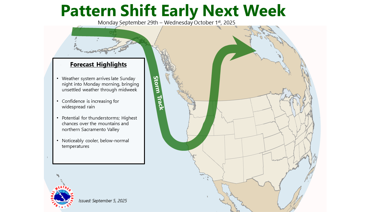
September 30, 2025 at 6:39 AM NWS update: Showers continue to move through the Sierra and foothills this morning with breezy conditions elsewhere. Further chances for showers and isolated thunderstorms this afternoon and evening. A secondary system Wednesday through Friday brings scattered showers and isolated thunderstorms to the region.

September 29, 2025 at 8:51 PM Fire on Walker has been extinguished, homeowner has been educated.
September 29, 2025 at 8:37 PM Debris check on Walker and Stephen Ave in Auburn, units dispatched.
September 29, 2025 at 4:45 PM A reportedly large stack of hay is blocking the roadway on southbound Hwy 49 at the Hwy 174 on ramp. Use caution in the area and not a good spot to go looking for that proverbial needle.
September 29, 2025 at 4:09 PM Units at scene on Lark Street have a good knockdown on the fire, one engine to continue in, all others can cancel.
September 29, 2025 at 4:06 PM First unit on Lark reports soom smoke shoeing from the engine compartment.
September 29, 2025 at 4:04 PM Reported passenger vehicle fire on Lark Street in Penn Valley, units dispatched.
September 29, 2025 at 3:36 PM Nevada City updates: Public Works is inspecting and cleaning drains after the passage of the street sweeper. The first significant rain after summer season is also called first flush – Public Works is doing their part to minimize any blockages. In other news, Joan Phillippe is back at the helm of Starship City Hall as Interim City Manager.
September 29, 2025 at 3:15 PM Pallets and other debris across the onramp lanes on southbound Hwy 49 at Gold Flat.

September 29, 2025 at 10:53 AM Smoke check in the Colfax area, Butte View Place and Retherford Rd. Smoke visible on the cameras, units dispatched.
September 29, 2025 at 10:03 AM Traffic hazard on Hwy 20 at Pleasant Valley Road. The traffic lights are out of commission, use extreme caution at the intersection.
September 29, 2025 at 8:20 AM The small refuse fire at the McCourtney Road Transfer Station under the overhang of the customer drop-off bay has been extinguished and the engines have returned to their station.
September 29, 2025 at 6:26 AM Southbound Hwy 49 at Allison Ranch Rd is transformed into a slalom course with plastic bags in the roadway.
September 28, 2025 at 5:35 PM Units are at scene on Carrie Dr, extinguishing the pile now.
September 28, 2025 at 5:21 PM Debris check on Carrie Dr in Alta Sierra. No, just because it’s a little cooler you still may not light a burn pile.
September 28, 2025 at 4:00 PM Smoke check in the Hobart Mills area, on Timber Trails Rd, reported campfire in the area. Units dispatched.
September 28, 2025 at 11:18 AM Butte IC reports burnt food only, no fire. Canceling the response.
September 28, 2025 at 11:14 AM First unit at scene reports nothing showing from the outside, they will investigate.
September 28, 2025 at 11:09 AM Reported residential structure fire on Butte View Drive off Ridge Road in Grass Valley, units dispatched. Reported as smoke in the kitchen, no flames seen.
September 28, 2025 at 11:08 AM Blue IC is requesting one water tender to continue in, all others can cancel.
September 28, 2025 at 11:04 AM Additional units arriving at the Blue incident. Helicopter 514 is continuing in for now.
September 28, 2025 at 11:01 AM First unit at scene on Blue Sage reports no extension to the wildland at this time.
September 28, 2025 at 10:47 AM Trailer on fire on Blue Sage Way off Oak Tree Road in North San Juan, flames are visible. Threat to the vegetation, full wildland dispatch on order.
September 28, 2025 at 9:58 AM NWS update: A few isolated showers or thunderstorms may develop over the Sierra Crest this afternoon south of I-80, but dry conditions will prevail elsewhere across interior northern California. Two weather systems will bring unsettled weather starting tomorrow, and will continue through Thursday. Showers, isolated thunderstorms, breezy onshore winds and below normal temperatures will accompany these systems. For the mountains/areas north of Interstate 80, rainfall could be moderate to heavy at times, especially with any thunderstorms that develop. Thunderstorm chances have trended down for Tuesday, so the best chances are on Monday. Drier weather returns Friday into the weekend.

September 27, 2025 at 7:41 PM Bike found in the off the bike path at the previously reported accident on Penn Valley Dr, medics dispatched.
September 27, 2025 at 7:06 PM Non-injury accident on the 18000 block of Penn Valley Dr, the roadway is clear.
September 27, 2025 at 4:21 PM Car vs animal on Hoyt Crossing Rd, car overturned. No injuries reported.
September 27, 2025 at 8:28 AM Support the Bear River High School music program from 10am-2pm at Bear River High School today. There will be a car wash, a bake sale and live music to help students raise funds for a trip to SeaWorld and the San Diego Symphony.

September 26, 2025 at 7:27 PM The reported fire on Hwy 20 is a propane fire at the Washington overlook, units are at scene. Propane stoves are permitted during fire restrictions. Cancelling incoming resources.
September 26, 2025 at 5:58 PM Air Attack 230, Tankers 88 and 89 are committed to the Pyramid fire on the Amador-Eldorado unit.
September 26, 2025 at 3:28 PM The reported new start was an accidental activation of an automated beacon.
September 26, 2025 at 3:19 PM Possible new start in the Downieville area near Wild Plum campground.
September 26, 2025 at 1:50 PM Updates on the Oregon Fire will be posted here.
September 26, 2025 at 1:46 PM Difficult access for firefighters, resources are staging on Allegheny Rd.
September 26, 2025 at 1:41 PM Air Attack 17 requesting three helicopter total to the Oregon Fire. Oregon IC is requesting one additional crew and two water tenders.
September 26, 2025 at 1:34 PM Air Attack 17 requesting one Type 1 helicopter and two additional tankers to the Oregon incident, reporting 2-3 acres burning at a moderate to high rate of spread.
September 26, 2025 at 1:31 PM Tankers and Air Attack are arriving over the Oregon incident.
September 26, 2025 at 1:28 PM Firefighters are attempting to make access to the fire from Allegheny Rd. Air Attack 17 is lifting from Grass Valley.
September 26, 2025 at 1:25 PM The fire is on Alleghany Rd, just past the Oregon Creek day use area. Helicopter 514 has lifted from White Cloud.
September 26, 2025 at 1:22 PM This will be the Oregon incident per Tahoe National Forest.
September 26, 2025 at 1:18 PM Now reported as a camper on fire with extension to the vegetation on Ridge Rd and Hwy 49 south of Downieville.

September 26, 2025 at 1:14 PM Reported vegetation fire on Alleghany Ridge Rd between Allegheny Ridge Rd and Allegheny Rd. Full wildland dispatch on order.
September 26, 2025 at 12:56 PM Nice shot from the AlertCalifonia camera on Duncan Peak of a dust devil, first reported by the lookout. Tahoe National Forest resources confirmed it was a dust devil only, not a column from a fire.

September 26, 2025 at 12:55 PM Reader Maggie sent this photo of a lost dog on Solar Drive off Dorsey Dr. Is your pup safe?

September 26, 2025 at 12:31 PM Field report from Sheila: No left turn on Ridge Road to get to Sierra College. The road is closed.
September 26, 2025 at 10:47 AM Small 0.7 acre burn on Auburn Rd in Grass Valley. Ignition began at 10:00 AM, lasting approximately 2 hours. Permits in place, adequate persons, water, equipment and safe prescription for burning at that time. This small burn is conducted to ascertain the effects of burning grassland at this time of year (before wetting rains, but late enough to come into a reasonable fire prescription window). They want to provide lethality to invasive species (barbed goatgrass) while enhancing growth of native plants.


September 26, 2025 at 10:46 AM Nevada County Connect update: Fowler Center and Tractor Supply Stops Closed on Nevada City Hwy Due to Construction. Please be advised that all bus stops on Nevada City Hwy between Brunswick Rd. and Banner Lava Cap Rd. are Closed due to street resurfacing. We apologize for this inconvenience.
September 26, 2025 at 8:55 AM Traffic alert (also, poor timing alert) one way traffic on the downhill side of Nevada City Hwy just past Banner Lava Cap. No traffic control at the Brunswick intersection. Definitely use an alternate route or settle in for long wait times. Thanks to Greg for the photo.

September 26, 2025 at 8:02 AM Two pups are running in the roadway on Hwy 49 at Old Downieville Hwy. If you’re driving in the area, watch out for them because they’re too busy having fun to notice you.
September 26, 2025 at 6:44 AM NWS update: Low humidity and breezy north winds will bring critical fire weather conditions to the northern Sacramento Valley today and tonight. Showers and isolated thunderstorms are possible for the Sierra south of I-80 over the weekend. A cool, wet system early to mid-next week with widespread rain showers and an increasing potential for thunderstorms. Temperatures will cool to well below normal from early to mid next week.

September 25, 2025 at 8:09 PM We have received multiple reports from readers about possible shooting stars visible in the sky around 7:45 pm. We are in the process of confirming that is was likely the re-entry of a satellite. Please stand by, we want to give you accurate info. [confirmed as satellite re-entry.]
September 25, 2025 at 6:12 PM Solo vehicle accident, car into the center divide on Hwy 49 at the Idaho-Maryland off ramp.
September 25, 2025 at 5:13 PM Reader report of massive backup on Hwy 49 from Bell Road in Auburn to the construction zone at Lorenson (roundabout.) Use an alternate route if possible.
September 25, 2025 at 2:38 PM Units are at scene of the two-car accident on Hwy 49 in North San Juan. Both vehicles need to be towed.
September 25, 2025 at 2:27 PM Accident on Hwy 49 in North San Juan at Heesche Ave, units dispatched.
September 25, 2025 at 12:50 PM Thanks to reader Jeff for sharing this photo, taken by his wife Gale, confirming that Fall is here.

September 25, 2025 at 11:48 AM Traffic hazard on the northbound Hwy 49 Gold Flat off ramp. Use caution, it’s more than just the usual distracted drivers swerving.
September 25, 2025 at 8:24 AM The National Weather Service in Sacramento has issued a Red Flag Warning from 5 AM Friday to 5 AM Saturday for the far Northern Sacramento Valley.

September 25, 2025 at 7:57 AM The Plumas National Forest is dropping from Stage II to Stage I Fire Restrictions on Thursday, September 25, due to somewhat reduced fire danger. Recent thunderstorms have been wet and the long-term forecast includes cooler temperatures and chances for rain. While daytime temperatures are remaining warm to hot, humidity recovery is improving overnight, helping reduce the risk of fire. In Stage I Fire Restrictions, campfires are only allowed in specific designated recreation sites in established campfire rings.
September 25, 2025 at 7:26 AM A large brown dog is running in the roadway on eastbound Hwy 20 at Rough & Ready Hwy. Use caution, the pup is running against traffic flow.
September 24, 2025 at 6:01 PM The City of Nevada City and City Manager Sean Grayson have mutually agreed to part ways, effective Sunday, September 28, 2025.
September 24, 2025 at 5:24 PM Reported accident in the vicinity of the 12800 block of Garden Bar Rd, units dispatched.
September 24, 2025 at 4:42 PM The first job of local government is public health & safety, and fiscal responsibility. Our job is to ask questions to report the news and provide context. Being in public service is not an easy job, granted. Stonewalling media for no apparent reason results only in more questions. Commentary: Nevada City, you have a communications problem.
September 24, 2025 at 1:18 PM Traffic hazard on southbound Hwy 49 at Combie. A pile of drywall is causing motorists to swerve. Also, no instructions on what the completed project is supposed to look like.
September 24, 2025 at 10:23 AM First unit at scene on Meadow Court requests one more engine to continue in, all others can cancel.
September 24, 2025 at 10:17 AM Residential structure fire, water heater on fire, on Meadow Court in Placer County. Units dispatched.
September 24, 2025 at 8:55 AM Accident on Hwy 49 near Reader Ranch Rd. Units at scene report the roadway is partially blocked. No injuries reported.
September 23, 2025 at 1:45 PM Solo vehicle accident on Hwy 49 at the Bear River.
September 23, 2025 at 1:21 PM First Rain is conducting a 2.5 acres prescribed burn until 3pm at the junction of Rock Creek Rd x Rector Rd two miles outside of Nevada City, CA. Smoke may be widely visible for a short duration, and may linger into the evening. This burn is approved by CalFire, according to First Rain.

September 23, 2025 at 1:17 PM Firefighters have knockdown on the trailer fire and the vegetation portion, the spot fire is contained. Releasing the incoming crews and the aircraft.

September 23, 2025 at 1:08 PM Air Attack and Tankers 88 and 89 have lifted from Grass Valley, Helicopter 514 is off White Cloud.
September 23, 2025 at 1:05 PM Units at scene of the Spring incident report about 1/4 acre of vegetation now involved, one small spot across Marysville Rd.
September 23, 2025 at 1:01 PM Units at scene on Marysville Rd confirm sparse spread to the vegetation, about a 20 by 20 spot. The travel trailer is fully involved. This will be the Spring incident.

September 23, 2025 at 12:57 PM Aircraft now dispatched to the fully engulfed travel trailer on Marysville Rd.

September 23, 2025 at 12:54 PM Reported vehicle fire on Marysville Rd at Spring valley. Some spread to the wildland reported, units dispatched.
September 23, 2025 at 11:06 AM Reader Megan reports: These two black lab puppies without collars or leashes were roaming and running through the Grocery Outlet parking lot in Brunswick. Another Good Samaritan will be taking them over to Sammy’s Friends when they open up in an hour.

September 23, 2025 at 9:30 AM Power has been restored in the Nevada City area fo the unplanned outage.
September 23, 2025 at 8:24 AM Power outage affecting 3,360 customers in Nevada City and surrounding area. Estimated time of restoration is 12:15 pm.

September 23, 2025 at 7:29 AM Reader Michael reminded us of the Dog Bar bridge closure. Here you go: The Dog Bar Bridge Replacement Project on Dog Bar Road at the Bear River will have a full road closure from 4 a.m. to 12 p.m. on Tuesday, Sept. 23.
September 23, 2025 at 6:38 AM NWS update: Above normal temperatures are expected today with widespread Moderate HeatRisk across the Valley, Delta, and foothills. Periodically breezy north to east winds are expected into Wednesday morning with lowering humidity. The strongest winds are anticipated across portions of the Sacramento Valley along and west of Interstate 5 and in the Sierra, especially through canyons and over ridges. A system arrives by Wednesday, bringing the potential for isolated showers and thunderstorms, highest chances from I-80 southward, including the Valley. Lingering afternoon/evening thunderstorm chances continue Thursday and Friday over the Sierra I-80 southward.


September 23, 2025 at 6:30 AM As a reminder, one-way traffic control is starting and a planned power outage in the Banner Lava Cap area at 8:00 am.
September 22, 2025 at 11:55 PM Star IC reports the firefighters found a faulty powerstrip. No fire, the strip has been removed, all units are available.
September 22, 2025 at 11:35 PM Units are at scene on Star Dr, they’re investigating.
September 22, 2025 at 11:29 PM Smell of electrical burning, no flames seen, in a house on Star Dr off Greenhorn Rd. The house has been evacuated, units dispatched.
September 22, 2025 at 5:10 PM Traffic hazard on Hwy 174 at You Bet Rd, a truck is stuck with the ramp down. Use caution and no, it’s not an invite to hitch a ride.
September 22, 2025 at 4:37 PM Non-injury accident on Magnolia Rd at East Hacienda Dr, the roadway is reportedly clear.
September 22, 2025 at 1:45 PM Firefighters have contained the small fire on Lightning Tree, canceling the incoming resources.
September 22, 2025 at 1:25 PM TNF resources to assist with the small burn pile on Lightning Tree Rd. Air Attack and both tankers are being dispatched out of unit to the Mosswood and Uphill incidents in the Amador-El Dorado unit.
September 22, 2025 at 1:18 PM The fire is about 1/4 mile down from Washington Ridge Camp. Small spot only. Tanker 88 is leaving the incident.
September 22, 2025 at 1:13 PM Tanker 88 is over the area.
September 22, 2025 at 1:11 PM Full wildland dispatch for reported smoke on Cooper Rd between Cooper and Lightning Tree Rd just outside of Nevada City. Haze visible on the cameras.
September 22, 2025 at 1:10 PM In case you want to watch the interviews for the Clerk Recorder/Registrar of Voters position.

September 22, 2025 at 9:59 AM Non-injury accident on Lower Colfax Rd at Laws Ranch Cross Rd, the roadway is clear.
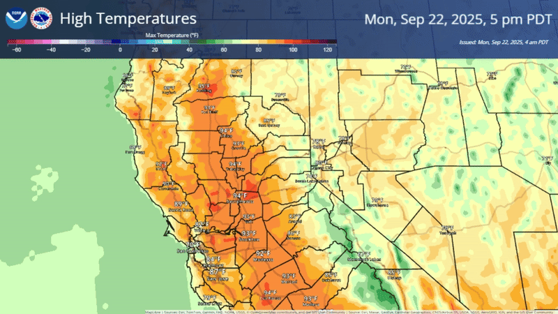
September 22, 2025 at 6:53 AM NWS update: Dry weather with well above normal temperatures is expected today and Tuesday, with widespread Moderate HeatRisk across the Valley, Delta, and foothills. The high temperature in Stockton on Tuesday may come close to the record of 101, set in 2002.
Periods of breezy north to east winds are expected to continue through Tuesday morning with lowering humidity. The strongest winds are anticipated across portions of the northern/central Sacramento Valley along and west of Interstate 5 and in the Sierra, especially through canyons and over ridges.
September 22, 2025 at 6:19 AM Traffic hazard on Bitney Springs Rd at Newtown, stranded pickup in the westbound lane (with hazard lights on.)
September 21, 2025 at 5:35 PM Per units at scene on Kneebone, medic can handle. All incoming resources can cancel.
September 21, 2025 at 5:20 PM Better location for the medical rescue is Kneebone beach.
September 21, 2025 at 5:17 PM Units dispatched for a medical rescue in the vicinity of the covered bridge at Bridgeport.
September 21, 2025 at 1:14 PM The Constitution Day Parade is about to start in Nevada City.
September 21, 2025 at 12:37 PM Units at scene on Hwy 20 near Omega report the westbound lane is blocked.
September 21, 2025 at 12:28 PM Two-car accident on eastbound Hwy 20 near Washington Rd, units dispatched.
September 21, 2025 at 12:02 PM Lower IC reports the fire was contained to the deck as a 2 by 5 spot, no extension to the structure or the vegetation.
September 21, 2025 at 11:34 AM First unit at scene on Lower Colfax reports this is not a vegetation fire. It was a fire on the deck of a residence, already extinguished. They cam handle, canceling all resources.
September 21, 2025 at 11:30 AM Now a full wildland dispatch for the reported fire in a front yard on Lower Colfax Rd. This will be the Lower incident.
September 21, 2025 at 11:28 AM Reported vegetation fire on Lower Colfax Rd just past Powerline Rd, units dispatched.
September 21, 2025 at 8:07 AM NWS update: Above normal temperatures are expected early this week with widespread Moderate HeatRisk across the Valley, Delta, and foothills Monday-Tuesday. Dry conditions prevail across the area early this week, although there is a slight chance (10-20%) for isolated thunderstorms along the southern Cascades and Sierra crest south of Highway 50 this afternoon and evening. Periodically breezy north to east winds are expected late tonight through Tuesday morning with lowering humidity. The strongest winds are anticipated across portions of the northern/central Sacramento Valley along and west of Interstate 5 and along the Sierra. The next system arrives by mid-week, bringing the potential for isolated showers and thunderstorms. At this point, the best potential looks to be along and south of I-80, especially over the Sierra. Lingering afternoon/evening thunderstorm chances continue Thursday and Friday over the Sierra I-80 southward. Confidence is low with this system so please stay tuned to updates.

September 20, 2025 at 10:35 PM Firefighters have removed the tree and Dog Bar Rd is fully open.
September 20, 2025 at 9:56 PM Tree down on Dog Bar Rd near Magnolia Rd, one-way traffic control in place for now.
September 20, 2025 at 8:48 PM So far, multiple engines have been unable to locate the source of the reported smell of gas.
September 20, 2025 at 8:30 PM Reported gas hazard in the Glenbrook Basin. Units are in the area attempting to locate.
September 20, 2025 at 4:20 PM From a reader: A lost looking brown and white border collie seen on Whiting St. in Grass Valley. Is your pup safe?
September 20, 2025 at 2:16 PM Units in the area of the roundabout in Grass Valley are unable to locate any accident.
September 20, 2025 at 2:14 PM Car vs bike on East Main at Idaho-Maryland Rd, units dispatched.
September 20, 2025 at 1:53 PM Motorcycle down on Hwy 49 at Depot Hill just north of the Sierra County line, units dispatched.
September 20, 2025 at 11:17 AM Possible illegal campfire at the Bear River recreation area, units dispatched.
September 20, 2025 at 7:47 AM NWS update: Slight chances (10-25%) for isolated showers and thunderstorms over the mountains this afternoon and evening. Highest chances for thunderstorms will be over the Coast Range and Shasta County mountains. There is a slight chance (10-15%) for isolated thunderstorms over the Sierra crest and southern Cascades on Sunday. Drier and warmer conditions return early next week, with some areas of Moderate HeatRisk in the Valley. Locally breezy northerly winds develop late Sunday night through midday Monday, mainly across portions of the northern Sacramento Valley along and west of Interstate 5.

September 19, 2025 at 8:22 PM Utility power has been restored to all customers affected by the large outage in Penn Valley and Rough & Ready. Three separate outages, affecting one customers each remain in the area.
September 19, 2025 at 8:06 PM The PV outage has been reduced to 1,082 customers. Trouble crew found an object making contact with the power line and will make repairs.
September 19, 2025 at 7:48 PM The reported burn pile on Rough & Ready Hwy was someone burning old mail, the pile is being extinguished.
September 19, 2025 at 7:44 PM Now 3,025 customers out of power from the one outage. Automatic estimate of restoration is 1:15 am.
September 19, 2025 at 7:36 PM Debris check on 13300 block of Rough & Ready Hwy, possible burn/trash pile.
September 19, 2025 at 7:30 PM Smoke in the Tack Room in Penn Valley after the power outage, building will be ventilated by firefighters.
September 19, 2025 at 7:19 PM Units at scene on Hwy 49 report this is not garbage burning, it’s an unattended BBQ.
September 19, 2025 at 7:18 PM A total of 2,912 customers are out of power in Penn Valley and Rough & Ready.

September 19, 2025 at 7:14 PM Report of power lines arcing on Sierra Circle off Spenceville Rd. Units dispatched and might well be the cause of the outage.
September 19, 2025 at 7:12 PM Reader Greg reports a power outage in Rough & Ready. PG&E appears unaware…
September 19, 2025 at 7:07 PM Debris check on Hwy 49 in North San Juan, i front of the Senior Center. Reported as burning trash, not spreading into the vegetation. Uist dispatched.
September 19, 2025 at 6:33 PM Most entries for the day were logged on my local machine only (cache issue) – apologies for the lack of visible updates. Restarted, all is well again.
September 19, 2025 at 11:13 AM Smoke check on La Porte Rd in the Brownsville area, possible burn pile. Units dispatched.
September 19, 2025 at 9:00 AM As a reminder, the burn suspension remains in effect. No burn piles allowed.
September 19, 2025 at 7:42 AM Units at scene on Hwy 174 report minor injuries only, the roadway is clear.
September 19, 2025 at 7:08 AM Head-on collision on Hwy 174 at White Oak Dr. units dispatched.
September 19, 2025 at 6:45 AM NWS update: Isolated to scattered showers and thunderstorms are expected today. Showers in the Valley diminish through the day, but continue in the mountains. Highest chances for thunderstorms will be over the Sierra this afternoon, especially south of I-80. Shower and thunderstorm activity end overnight.

September 18, 2025 at 3:13 PM The Skyview incident has been contained at 6 acres, per the IC. All resources will be committed for 3-4 hours.
September 18, 2025 at 2:53 PM All aircraft is released from the Skyview incident.
September 18, 2025 at 2:47 PM Tankers 88 and 89 are being released from the Skyview incident, they are at the Grass Valley Air Attack Base.
September 18, 2025 at 2:41 PM Skyview IC reports they have a hoseline around the fire, calling it shaky containment. There are evacuation warnings in place for zones YUB-E008, YUB-E094-A and YUB-E017.
September 18, 2025 at 2:33 PM Skyview IC reports approximately 4-5 acres and they have retardant on both shoulders. Ground resources are making good progress. Air Attack 230 is returning to Grass Valley, Air Attack 658 is assuming Skyview Air Attack.
September 18, 2025 at 2:30 PM Tanker 100 has lifted from Chico and Air Attack 658 from Chico is over the fire as well.
September 18, 2025 at 2:26 PM Tankers are working the flank of the fire closest to the structure. Ground resources have started the hoselay. Helicopter from White Cloud is dipping into Collins Lake for bucket work.

September 18, 2025 at 2:20 PM Aircraft are overhead the Skyview incident, AIr Attack is ordering one additional tanker and one additional helicopter. The fire is close to structures. Tankers are taking action now.
September 18, 2025 at 2:17 PM First unit at scene on Skyview reports slow to moderate rate of spread, all resources dispatched to continue in.
September 18, 2025 at 2:15 PM Aircraft have lifted from Grass Valley to the Skyview incident.
September 18, 2025 at 2:05 PM Full wildland dispatch for a reported vegetation fire on Skyview Ct above Collins Lake.

September 18, 2025 at 12:34 PM Showers and thunderstorms today through Saturday with elevated fire weather conditions. Remnants from former Tropical Storm Mario will bring periods of showers and thunderstorms today through Saturday. There will be a short period with the potential for new fire starts tonight with isolated dry thunderstorms before the atmosphere moistens up and the risk shifts to a heavy rain threat. Currently, heavy rain potential is highest over the Sierra.

September 18, 2025 at 9:53 AM This sweet little guy was found roaming in a yard on Banner Lava Cap. He has a blue Fi collar on, but no name or contact information. He will be at Sammie’s Friends.

September 18, 2025 at 7:39 AM Units at scene on Hwy 49 report this is not an accident, pickup ran out of gas.
September 18, 2025 at 7:35 AM Accident on southbound Hwy 49 at La Barr Meadows, units dispatched.
September 18, 2025 at 6:37 AM How much horsepower does it take to go see the Draft Horses? No idea, but you can ride any Nevada County bus for free today through Saturday 😉
September 17, 2025 at 7:42 PM The smoke in the river canyon and along Lake Vera/Purdon is from the prescribed burn on Rector. There is no other fire at this time.
September 17, 2025 at 7:35 PM One way traffic control on Hwy 49 at Shoshoni Trail Ct until the vehicles are towed.
September 17, 2025 at 6:46 PM Accident on Hwy 49 near Shoshoni Trail Ct, two cars involved. Emergency services at scene, the roadway is blocked.
September 17, 2025 at 4:22 PM Firefighters have located an active leak and will shut down the gas supply to the Holiday Complex, per Combie IC.
September 17, 2025 at 4:16 PM Units are at scene on Higgins and are investigating.
September 17, 2025 at 4:11 PM Reported leak from a propane gas line at the Holiday Market on Higgins Rd. Units dispatched.
September 17, 2025 at 12:10 PM One lane of Hwy 20 near Omega is blocked by a semi with trailer that ran out of gas. Emergency services are at scene. Use caution and reduce your speed.
September 17, 2025 at 9:55 AM The 20-acre prescribed burn on Rector Rd outside of Nevada City is underway. Smoke may be visible.
September 17, 2025 at 9:26 AM Emergency services are responding to a medical emergency, not a fire, on Clay St in Nevada City.
September 17, 2025 at 8:26 AM A box is sprawling in the off ramp of southbound Hwy 49 at Dorsey Dr.
September 17, 2025 at 8:22 AM Firefighters have checked the Allison Ranch area, nothing showing. All engines returning to their stations.
September 17, 2025 at 8:18 AM Units at the given address on Allison Ranch Rd report no vehicle in the area. They will investigate.
September 17, 2025 at 8:13 AM Passenger vehicle fire on Allison Ranch Rd, units dispatched.
September 17, 2025 at 6:52 AM First Rain Land Stewardship Services will be conducting a Rx burn today.
Location: 19832 Rector Road Nevada City, CA
Acres: 20.5
This is a reburn of an area previously burned under Rx burn conditions in 2023. This is a forest maintenance burn aimed at further reducing fuels accumulation to support an increase in herbaceous understory vegetation.
September 17, 2025 at 6:34 AM NWS update: Above normal temperatures and Moderate HeatRisk continue today before temperatures cool closer to normal through the rest of the week. A pattern shift toward more active weather is still on track Thursday-Saturday as subtropical moisture from the remnants of Tropical Storm Mario stream northward. Lightning from isolated thunderstorms is expected to result in some periods of elevated fire weather concerns. Thursday: Lingering uncertainty on timing of precipitation onset, but some potential for scattered showers/embedded thunderstorms across the Valley/foothills throughout the day. Higher potential for isolated thunderstorm development late Thursday into early Friday. Friday: Thunderstorm chances around 15-25% shift to the Sierra/southern Cascades by Friday afternoon/evening. Saturday: Slight chances (10-15%) for isolated thunderstorms expand to include the Shasta County mountains.

September 16, 2025 at 4:08 PM Power has been restored to the customers along the Hwy 20 corridor.
September 16, 2025 at 4:01 PM Now possible vegetation involved at the structure fire on Pear Valley Ln off Clipper Gap in the Auburn area.
September 16, 2025 at 3:59 PM Reported structure fire off Clipper Gap Rd, units dispatched.
September 16, 2025 at 3:46 PM Vehicle vs motorcycle on Empire Street near the off ramp. Units dispatched.
September 16, 2025 at 2:20 PM 463 customers remain out of power along Hwy 20 due to an emergency repair.
September 16, 2025 at 1:16 PM A car is going down the wrong way on Commercial St in Nevada City.

September 16, 2025 at 1:15 PM Semi truck fire on westbound I-80 at Penryn, numerous units dispatched.
September 16, 2025 at 9:52 AM Power outage affecting 194 customers in the Hwy 174 at Bear River area now has a restoration time of 2:00 pm.

September 16, 2025 at 6:55 AM NWS update: Above normal temperatures and dry weather continues today and Wednesday with Moderate HeatRisk expected for much of the Delta and portions of the Valley and foothills. A shift toward near normal temperatures and more active weather is still expected from Thursday onward with shower and thunderstorm chances looking to increase as subtropical moisture streams northward. There is still notably high uncertainty at this time with respect to the timing and location of any initial thunderstorm development, particularly Thursday into early Friday. Best potential for Valley/foothills thunderstorms currently looks to be overnight Thursday into Friday morning. Highest thunderstorm chances are anticipated on Friday afternoon/evening along the Sierra/southern Cascades with still slight chances of lingering mountain thunderstorms expanding to include the Coast Range/Shasta County mountains Saturday afternoon/evening. A slight warming trend is then expected through the weekend with at least a brief period of drier weather late weekend into early next week.

September 15, 2025 at 7:12 PM Hwy 49 at McKnight is reopening in both directions.
September 15, 2025 at 7:01 PM Hwy 49 at McKnight is being shut down for a law enforcement operation. There is no danger to the public.
September 15, 2025 at 4:01 PM Final size for the Hedges incident is 4.81 acres per the IC. The evacuation warnings for zones YUB-E092 and YUB-E096 have been lifted.
September 15, 2025 at 3:48 PM Air Attack is releasing both tankers back to Grass Valley.
September 15, 2025 at 3:35 PM Firefighters have knockdown on the structure fire and forward progress of the vegetation portion has been stopped.

September 15, 2025 at 3:00 PM Retardant is lining 75% of the fire. The correct location of the fire is Forsythe Rd. Crews are making access to the vegetation portion now, helicopters are working the hotspots.
September 15, 2025 at 2:57 PM Tankers are dropping on the head of the fire to slow progression. Firefighters on the ground are working the structure fire and the wildland fire.

September 15, 2025 at 2:51 PM Air Attack reports the fire is bordered by a canal on one side, some structures in the area potentially threatened. The fire is burning in a previous burn, light fuels only.

September 15, 2025 at 2:47 PM Air Attack is overhead, assuming Hedges Air Attack. Hedges IC reports a fully involved structure, with extension to the wildland. The vegetation fire is burning at a moderate rate of spread in brush and timber.
September 15, 2025 at 2:44 PM Additional units are arriving at the Hedges incident, aircraft are arriving over the incident now.
September 15, 2025 at 2:42 PM Additional resources from the Plumas National Forest dispatched to the structure fire. Air Attack 230 and tankers have lifted from Grass Valley. Helicopter 514 has lifted from White Cloud.
September 15, 2025 at 2:39 PM Units have arrived at scene on Forsythe Rd, they are taking action now.
September 15, 2025 at 2:37 PM Access to the fire is on Indiana Ranch. Location is Indiana Ranch Rd and Forsythe Rd.
September 15, 2025 at 2:32 PM Residential structure possibly into the vegetation, full wildland dispatch on order, on Frenchtown Rd near Hedges Wy south of Brownsville.

September 15, 2025 at 12:12 PM Smoke visible from a semi truck on Hwy 49 at the Broad Street off ramp, units dispatched.
September 15, 2025 at 10:19 AM Health Alert: Illegal (unpermitted) Food Vendors. Nevada County Environmental Health Department urges the public to exercise caution when considering consuming food from vendors operating without proper health permits. There have been complaints from people who got sick after eating at these stands and the county is required to take action. Permitted food vendors display their county permits – meaning they are inspected and paid their license fees. Now you know.
September 15, 2025 at 6:57 AM Breezy north winds to continue through midday, with strongest gusts up to 20 mph in the northern/central Sacramento Valley. Warm and dry weather expected Today-Wednesday with areas of Moderate HeatRisk across the Delta, Valley, and foothills. Confidence is increasing in a trend toward more active weather from Thursday into the weekend as moisture from the eventual remnants of current Tropical Storm Mario is expected to stream northward later this week. Shower and thunderstorm chances (including nocturnal thunderstorm potential) look to accompany this push of moisture, but exact details regarding timing and location of thunderstorms remain uncertain at this time.

September 14, 2025 at 7:53 PM Car into a ditch on Norlene Way at Lawrence Way in Alta Sierra.
September 14, 2025 at 5:34 PM The Farad incident, a roadside spot on I-80, has been contained. Canceling all incoming resources.
September 14, 2025 at 5:18 PM Helicopter 514 from White Cloud, Air Attack 230 and tankers 88 and 89 from Grass Valley are inbound to the Farad incident.
September 14, 2025 at 5:07 PM Full wildland dispatch for a reported wildland fire on eastbound I-80 just west of Floriston. Roadside spot right of the roadway.
September 14, 2025 at 9:44 AM All resources will be committed for approximately one hour on the Red incident.
September 14, 2025 at 9:22 AM Red IC reports they have a line around the 1/4-acre fire. Forward progress has been stopped. Three engines and a crew to continue in, all others can cancel.
September 14, 2025 at 9:19 AM Access to the fire will be off Red Dog Rd. It will be the Red incident.
September 14, 2025 at 9:13 AM The fire is likely located in the Buckeye Ridge/Chalk Bluff area, according to reports.
September 14, 2025 at 9:08 AM Firefighters are in the area attempting to locate the origin of the fire. Air Attack 17 is available and will lift from Grass Valley. Helicopter 514 from White Cloud is also being dispatched. Additional engines also dispatched.

September 14, 2025 at 9:04 AM Another report puts the potential fire in the Red Dog/Buckeye area.
September 14, 2025 at 8:58 AM Report of smoke possibly in the You Bet area. Units dispatched.
September 14, 2025 at 12:16 AM All resources will be committed for 2-3 hours, extensive overhaul and mop-up. Fire was confined to the attic, no extension to the vegetation.
September 14, 2025 at 12:04 AM Hillcrest IC is canceling the dozer ad the incoming crew, they can handle with resources at scene.
September 13, 2025 at 11:56 PM Hillcrest IC requesting Red Cross to respond to the fire. Firefighters have established good waterflow and are making progress.
September 13, 2025 at 11:45 PM Hillcrest IC reports crews are working the attic fire, they have the all clear on the structure.
September 13, 2025 at 11:42 PM Firefighters will ventilate the roof of the structure.
September 13, 2025 at 11:38 PM Hillcrest IC reports the two-story structure is about 25% involved, no immediate threat to the vegetation. Dozer to stage at their present location.
September 13, 2025 at 11:35 PM First unit at scene reports a working roof fire on Hillcrest Drive, all resources to continue in.
September 13, 2025 at 11:32 PM Reported structure fire with threat to the vegetation on Hillcrest Drive off Banner Lava Cap, numerous resources dispatched.
September 13, 2025 at 6:39 PM Vehicle accident on Morning Sun Ln near Dog Bar Rd, no injuries reported.
September 13, 2025 at 6:14 PM Accident near the 16000 block of Rattlesnake Rd, units dispatched.
September 13, 2025 at 5:01 PM Report of a possible RV fire on Auburn Rd at McCourtney Rd, units dispatched.
September 13, 2025 at 3:41 PM Edwards IC reports one patient with moderate injuries, one medic to continue in, cancelling all other resources.
September 13, 2025 at 3:39 PM Firefighters have made contact with the patient at Edwards. Precautionary air ambulance dispatched.
September 13, 2025 at 3:36 PM No fire on Willow Valley Rd, training.
September 13, 2025 at 3:25 PM Water rescue at Edwards Crossing dispatched.
September 13, 2025 at 1:43 PM Firefighters made contact with the patient, no need for a rescue helicopter.
September 13, 2025 at 1:31 PM Units are at Bridgeport hiking in to make contact with the patient.
September 13, 2025 at 1:27 PM Medical rescue at Bridgeport, units dispatched. Patient is out of the water.
September 13, 2025 at 12:29 PM Thanks for checking in folks. It is really an uneventful day so far. Enjoy the lovely weather!
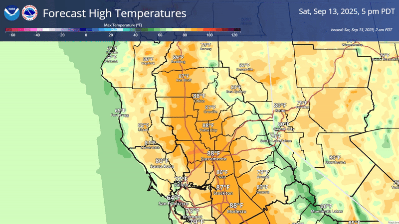
September 13, 2025 at 8:35 AM NWS update: North winds for Monday have trended down slightly, generally gusts will be 20 mph or less now. Temperatures for Thursday have trended down slightly as well, with larger areas in the Valley of Moderate HeatRisk only expected Tuesday and Wednesday now. Hottest day is still expected on Wednesday.
September 12, 2025 at 8:52 PM Units have searched the area, nothing located.
September 12, 2025 at 8:31 PM Units in the area of Brighton Street are attempting to locate a reported smell of sulphur aka a possible gas leak.
September 12, 2025 at 7:57 PM Units have located a smoldering pile in a fire ring on Hwy 49, extinguishing now.
September 12, 2025 at 7:42 PM Debris check, possible burn pile, in the Hwy 20/Conservation Rd area, units dispatched.
September 12, 2025 at 4:56 PM We talked to United Way of Nevada County’s Executive Director Louise Reed about the launch of their new emergency fund. Full story here.

September 12, 2025 at 10:51 AM Hanging out in the sun, what a way to start the weekend.

September 12, 2025 at 6:46 AM The NWS update: On Monday there will be some breezy northerly winds, mostly in the northern Sacramento Valley. Forecasted gusts remain below 25 mph with the latest forecast, and little impact is expected from these winds at this time. A warming trend begins today, briefly punctuated by a single day cool down on Sunday, before warming continues early next week. We’ll see some above normal temperatures and areas of Moderate HeatRisk on Tuesday through Thursday.

September 11, 2025 at 8:56 PM Auburn IC reports they cleared the whole building, no hazards found. All units are being released.
September 11, 2025 at 8:52 PM Units at scene on Cattail report the battery fire is out, canceling incoming resources.
September 11, 2025 at 8:47 PM Reported other type fire on Hwy 174 and Cattail Ln, a charging battery on an Ebike smoking heavily. Units dispatched.
September 11, 2025 at 8:35 PM Firefighters have searched the Vets Hall and surrounding areas, so far nothing showing. Auburn IC is releasing some of the units staged in the area.
September 11, 2025 at 8:25 PM GVPD is at scene for traffic control.
September 11, 2025 at 8:24 PM Auburn IC is requesting South Auburn near the Vets Hall to be shut down while they investigate.
September 11, 2025 at 8:23 PM Report of a possible fire at the Grass Valley Vets building. Units are at scene, investigating.
September 11, 2025 at 8:01 PM Heads up: Caltrans is alerting motorists about an upcoming extended lane reduction along State Route 49 (SR 49) at Lone Star Road this weekend as construction continues on a $38 million safety barrier and roundabout project. Crews will reduce northbound and southbound SR 49 to one lane in each direction starting at 6 a.m. Friday. Northbound SR 49 is scheduled to reopen to two lanes by 3 p.m. Monday, September 15. Southbound SR 49 is scheduled to reopen to two lanes by 6 a.m. Tuesday, September 16.
September 11, 2025 at 4:47 PM Power outage in Placer Hills is affecting 596 customers. Trouble crews are patrolling the circuit before reenergizing.

September 11, 2025 at 4:16 PM Units at scene on Sunset have knockdown on the three separate fires. They can handle with resources at scene and one additional water tender.
September 11, 2025 at 3:57 PM Multiple roadside spots along Sunset West near Fiddyment in the Roseville area, numerous units dispatched.
September 11, 2025 at 3:20 PM Accident on Highway 49 near Freeman Lane, units dispatched.
September 11, 2025 at 2:55 PM A dresser in the roadway on McCourtney Rd at Wolf Mountain rd. Decluttering has a different meaning than littering, look it up.
September 11, 2025 at 2:45 PM Shirland IC reports they can handle with resources at scene, they have knockdown on the fire. Air Attack 230, tankers 88 and 89 are returning to Grass Valley.
September 11, 2025 at 2:39 PM First unit at sceen on Shirland reports flames visible from the car, all resources to continue for now.
September 11, 2025 at 2:35 PM Full wildland dispatch for a reported passenger vehicle fire on Shirland Tract in south Auburn.
September 11, 2025 at 2:30 PM Two-car accident on Magnolia Road at Combie Road, the roadway is clear.
September 11, 2025 at 2:26 PM Nevada County has recently reported its first human case of West Nile virus for 2025. As of Sept. 5, the California Department of Public Health had received reports of 31 human cases this season, with most cases being reported from the southern Central Valley.
September 11, 2025 at 11:22 AM Two-car accident on Torrey Pines Dr at Lakeshore North in Lake of the Pines, units dispatched.
September 11, 2025 at 10:39 AM Firefighters have been busy this morning, chasing and extinguishing reported burn piles. As a reminder, the burn suspension is still in effect.
September 11, 2025 at 8:28 AM Non-injury accident on McCourtney Rd at Retrac, no further details available.
September 11, 2025 at 7:24 AM Equine stroll alert: Two horses are wandering in the roadway on Dog Bar Rd near Feather Way.
September 11, 2025 at 7:23 AM Thunderstorm chances for today have increased slightly, now around 15-30%. Thunderstorm chances for Sunday have dissipated further, now generally near 0% everywhere. Still expecting a slight warm up into the weekend, a very brief cool down on Sunday, followed by a bigger warm up going into mid next week. Mostly Minor HeatRisk is expected through Wednesday, though areas of Moderate HeatRisk appear in the Delta, southern Sacramento Valley, and Northern San Joaquin Valley by Wednesday. North winds will arrive Monday, and forecasted gusts have increased slightly in the northern Sacramento Valley, though still remain below 25 mph.

September 10, 2025 at 2:42 PM Accident on Dog Bar Rd at Wheeler Acres, one lane is blocked. Emergency services are at scene.
September 10, 2025 at 1:26 PM Thunderstorms are starting to pop up to the north and east of our area.

September 10, 2025 at 8:01 AM Vehicle accident on Ridge Rd at Rough & Ready Hwy, units dispatched. The roadway is blocked.
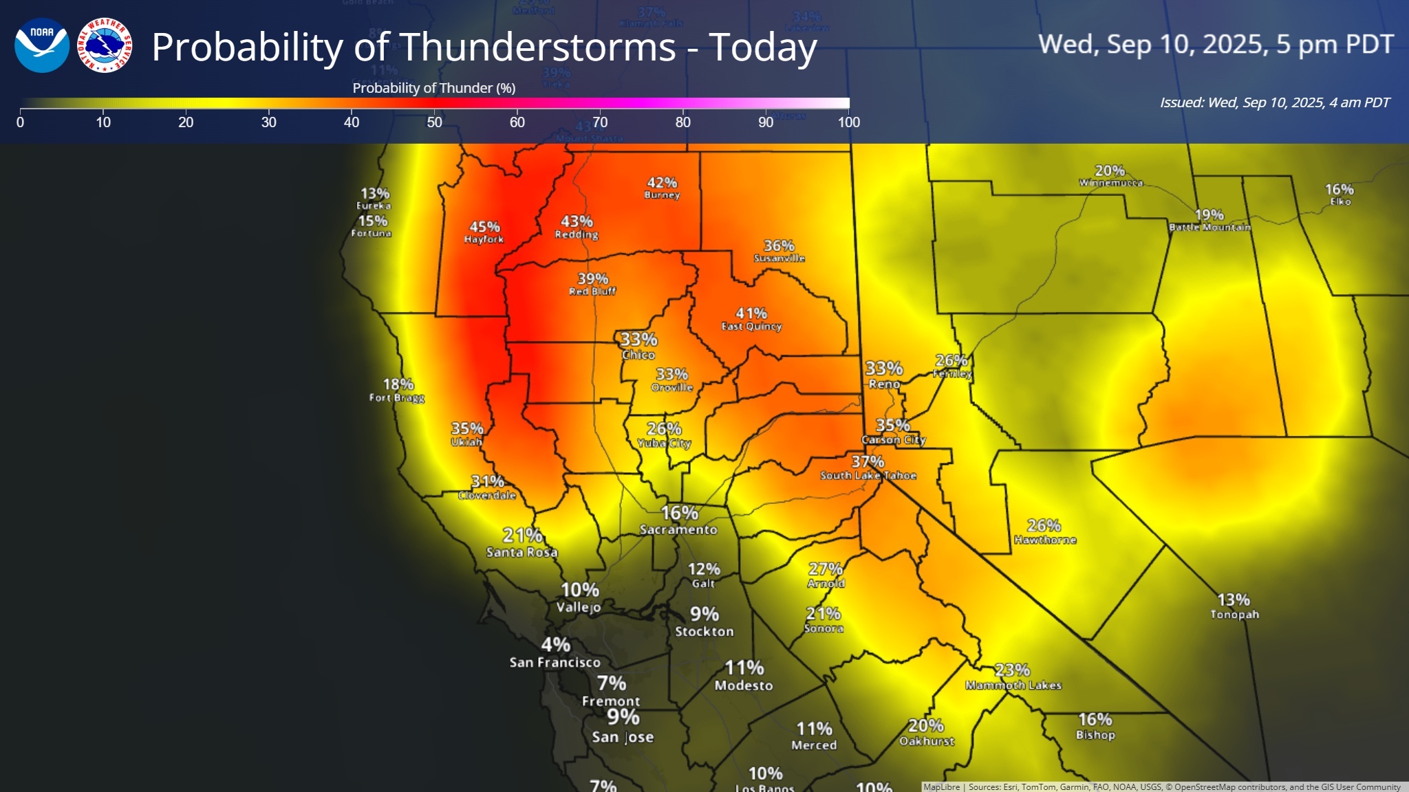
September 10, 2025 at 6:36 AM NWS update: A weather system over the area continues to bring showers and thunderstorm chances today and tomorrow. Best chances for precipitation over the northern Sacramento Valley, Coastal Range, and Sierra. Our thunderstorm chances for today are around 25-45%, highest in the northern Sacramento Valley where a low pressure is stalled, enhancing instability. Central Sacramento Valley showers and thunderstorms also possible today, best chances north of Sacramento.
September 9, 2025 at 7:11 PM Nancy IC reports they secured the propane tank, canceling incoming units.
September 9, 2025 at 7:04 PM Tree into a propane tank on Nancy Way near Brewer Rd in Alta Sierra, units dispatched for a safety check.
September 9, 2025 at 6:50 PM McKeon IC requests one engine an one prevention officer to continue, all others can cancel. Units at scene have knockdown on the fire.
September 9, 2025 at 6:46 PM Reported vehicle fire on Ponderosa Way at McKeon south of Todd Valley/Foresthill. First unit at scene reports no extension to the vegetation.

September 9, 2025 at 4:04 PM Non-injury accident on Rough & Ready Hwy and Ridge Rd, the roadway is clear.
September 9, 2025 at 1:55 PM Engine compartment has been contained, they can handle with resources at scene on Brunswick Rd.
September 9, 2025 at 1:53 PM Units at scene on Brunswick report one vehicle in the middle of the intersection, fire appears to be in the engine compartment.
September 9, 2025 at 1:50 PM Reported passenger vehicle fire on northbound Hwy 49 at the Brunswick Rd/Maltman Dr on ramp. Units dispatched.
September 9, 2025 at 1:26 PM No really, it’s quiet out there 🙂
September 9, 2025 at 9:38 AM Non-injury accident, vehicle off the embankment on Hwy 49 at the South Yuba, units dispatched.
September 9, 2025 at 8:30 AM Non-injury accident on Hwy 174 at East Empire St. the roadway is clear.
September 9, 2025 at 7:31 AM A weather system is moving through the area, bringing chances of showers and thunderstorms to the area today through Thursday.
- Today: Best chances of precipitation/thunderstorms in the northern Sacramento Valley and in the Sierra (mainly south of I-80), with chances around 20-35%. Around a 15-25% chance of nocturnal thunderstorms tonight/early tomorrow in the northern Sacramento Valley; confidence low on exact location of storm development.
- Wednesday: Storm chances slightly increased to 30-40% tomorrow, more widespread coverage expected in the northern Sacramento Valley and mountains.
- Thursday: 10-20% chance of thunderstorms, mainly in the Sierra south of I-80 and in the northern Sacramento Valley

September 8, 2025 at 9:30 PM Thanks to readers Matthew and Adrienne for the spectacular moonrise photos.


September 8, 2025 at 4:37 PM A reminder, NC Media’s Open House is happening now until 7:00 pm.


September 8, 2025 at 4:15 PM Reported fire start, units at scene with investigator on Torrey Pines Drive in Lake of the Pines. Fire is extinguished.
September 8, 2025 at 2:55 PM Joy IC reports they have extinguished the structure fire. Resources at scene will remain committed for an hour to mop up.
September 8, 2025 at 2:42 PM Joy IC requests two engines to continue in, and the Foothill resources,all others can cancel.
September 8, 2025 at 2:41 PM Canceling the dozers and all aircraft to the Joy incident.
September 8, 2025 at 2:36 PM Joy IC reports they have knockdown on the vegetation portion of the incident. Air Attack 230 and tankers have lifted from Grass Valley.
September 8, 2025 at 2:33 PM First unit at scene on Joy Circle reports a partially involved trailer, flames and smoke showing. All units to continue in.
September 8, 2025 at 2:31 PM Reported trailer fire with black smoke in the trailer park on Joy Circle, column not visible on the cameras.
September 8, 2025 at 2:27 PM Reported structure fire with threat to the vegetation on Joy Circle in Challenge, full wildland dispatch on order.
September 8, 2025 at 11:56 AM Local firefighters and resources committed to large wildfires throughout the state. All stations remain fully staffed.
September 8, 2025 at 10:19 AM Never too young to learn. A baby deer is exploring the field at Deer Creek School in Nevada City.
September 8, 2025 at 8:18 AM Power outage in Sierra County affecting 607 customers in Sierra City and the Downieville area. Estimated time of restoration is 2:45 pm.

September 7, 2025 at 3:43 PM No structure fire, smoke alarm due to burnt food. Canceling the response.
September 7, 2025 at 3:39 PM Reported structure fire on Sidehill Circle off Idaho-Maryland Rd. Units dispatched.
September 7, 2025 at 2:42 PM Tankers 88 and 89 have lifted from Grass Valley for a fire near Jackson Meadows. Air Attack 17 is over the Milton incident.
September 7, 2025 at 1:47 PM All aircraft has been released from the Dead incident, returning to their respective bases.
September 7, 2025 at 1:44 PM Dead IC reports forward progress stopped. One crew, two engines to continue in, all others can cancel.
September 7, 2025 at 1:41 PM Two helicopters dispatched to the Dead incident in addition to the two tankers and Air Attack.
September 7, 2025 at 1:39 PM Reported vegetation fire on Dead Horse Road near Woodacre Road at Sierra Knolls Estate. Units at scene report 1/4 acre, this will be the Dead incident.

September 7, 2025 at 1:01 PM Close, but no cigar. A WM bin in the roadway on westbound Hwy 20 just west of McCourtney.
September 7, 2025 at 7:51 AM Morning visitor at YubaNet HQ, a Cooper’s Hawk (or is it a Sharp-Shinned hawk?) Either way, those talons are impressive.

September 6, 2025 at 7:35 PM Power has been restored in Grass Valley, with the exception of 85 customers along East Bennett.
September 6, 2025 at 7:20 PM Now 2,754 customers out of power in Grass Grass Valley from Ridge Road to East Empire Street, per PG&E.

September 6, 2025 at 7:15 PM Reader reported power outage on Bennett St in Grass Valley.
September 6, 2025 at 10:12 AM Firefighters have located a small smoldering debris pile in a fire pit, extinguishing it now.
September 6, 2025 at 10:01 AM Power has been restored in Lake Wildwood, according to the PG&E map.
September 6, 2025 at 9:59 AM Smoke check on Auburn Ravine and Oak Tree Drive. Possible burn pile, units dispatched.
September 6, 2025 at 9:39 AM Power outage affecting 905 customers in Lake Wildwood. Must be Saturday…

September 6, 2025 at 9:31 AM Engines in the area on Banner Lava Cap are unable to locate a burn pile. Good.
September 6, 2025 at 9:10 AM Debris check on Banner Lava Cap Road, units dispatched. Neighbors in the area report a burn pile in a yard.
September 6, 2025 at 7:16 AM NWS update: Cooler weather is favored for interior NorCal over the next several days. A weather system will move through early next week bringing precipitation back to the forecast in shower and thunderstorm chances. Below normal temperatures and periodically breezy onshore winds can also be anticipated.

September 6, 2025 at 6:23 AM Thanks to reader Adrienne for the almost full moon photo.

September 5, 2025 at 4:57 PM Convict IC reports they have a hoseline around the fire.
September 5, 2025 at 2:44 PM Two tankers are over the Convict incident, with Air Attack 230 reporting 1/4 acre, slow rate of spread.
September 5, 2025 at 2:32 PM New vegetation fire, northeast of Convict Flat, units dispatched.
September 5, 2025 at 2:24 PM Vehicle accident on Magnolia Rd, extrication required. Units are at scene.
September 5, 2025 at 2:19 PM Firefighters at the Christian incident report still heavy fire in the structure, threat to the wildland remains.
September 5, 2025 at 2:11 PM Firefighters are making good progress on the Christian incident.

September 5, 2025 at 2:02 PM Vegetation fire on Christian Valley Road in Auburn, started as a structure fire, now into the vegetation. Units dispatched.

September 5, 2025 at 1:36 PM Wait and follow the Pilot Car on McCourtney Road. Nevada County is asking for drivers’ patience as crews continue rehabilitation work on McCourtney Road between Larkspur Lane and Indian Springs Road. Construction runs through early October from 7 a.m. to 7 p.m. Expect up to 20-minute delays.

September 5, 2025 at 1:20 PM Air Attack over the Keystone incident south of Sierra City is requesting two tankers to respond. Difficult access for ground resources, they’ll have to go in via the Pliocene Ridge access.

September 5, 2025 at 1:01 PM Reported vegetation fire south of Sierra Buttes, units dispatched.
September 5, 2025 at 11:09 AM Air Attack is flying a reconnaissance flight over the Tahoe National Forest to check for any additional lighting starts.
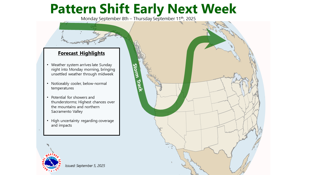
September 5, 2025 at 9:59 AM NWS update: A weather system will enter into our area next week bringing chances for showers and thunderstorms through the middle of next week, with the highest probabilities over the northern Sacramento Valley and mountains. Forecast confidence is low regarding precipitation coverage and attendant impacts. Temperatures will be noticeably cooler with Valley highs potentially in the upper 70s to low 80s.


September 5, 2025 at 8:10 AM Large power outage along I-80 from Meadow Vista up to Gold Run. 7,329 customers out of power in Placer County, including the Foresthill area. 920 customers out in Nevada County in the Rollins Lake and Bear River area.

September 5, 2025 at 7:07 AM Morning stretch on a power line.

September 5, 2025 at 6:23 AM The estimated time of restoration for the remaining 463 customers out of power along Rough & Ready Rd and Rough & Ready Hwy is now noon.

September 4, 2025 at 9:48 PM Readers report power is back on in Rough & Ready. However, 779 customers are still reported out by PG&E.
September 4, 2025 at 7:45 PM According to PG&E, 1,038 customers are out of power.

September 4, 2025 at 7:36 PM Reader reported power outage in Rough & Ready. No, we’re not simply recycling news, this is new – for today.
September 4, 2025 at 7:08 PM Only 41 customers on Keenan Way in alta Sierra remain without power. Estimated restoration time is 9:30 pm. Blame the tree that made contact with the power lines.
September 4, 2025 at 5:52 PM The power outage has been somewhat reduced. Now 1,432 customers remain out of utility power in the Alta Sierra area.
September 4, 2025 at 5:22 PM Power outage affecting 1,878 customers in the Alta Sierra area.

September 4, 2025 at 4:02 PM Reported vehicle accident on Zion Street, units dispatched.
September 4, 2025 at 1:12 PM Report made to law enforcement in the Seven Hills area was unfounded.
September 4, 2025 at 1:08 PM Law enforcement operation underway in the Seven Hills area.
September 4, 2025 at 10:19 AM Nevada County Connects update: Please be advised that Route 5 may run up to 30 minutes late due to significant road construction on Hwy 49 at Lone Star. Please be patient.
September 4, 2025 at 9:25 AM Low-hanging electrical lines at the corner of Sacramento St and Searls in Nevada City, units dispatched. No arcing reported.
September 4, 2025 at 6:14 AM NWS update: We will continue to trend cooler with temperatures as we approach the weekend and into next week. Seasonal highs today but ending up below normal as we head into the weekend and into next week. Shower and thunderstorm chances (10 – 20%) this afternoon and evening along the crest in the Sierra and southern Cascades.


September 3, 2025 at 5:18 PM A strong thunderstorm will impact Placer and Nevada counties through 5:45 pm. At 5:16 PM, Doppler radar was tracking a strong thunderstorm over Northstar, or near Prosser Creek Reservoir, moving northeast at 10 mph.

September 3, 2025 at 3:55 PM Reader Chris reports: A duck was found by Alta, white duck with clipped wings. Very sweet, looks like it was part of someone’s flock and looking for Mommy and Daddy. The duck is in a pond now, check your flock is complete.

September 3, 2025 at 2:08 PM The truck on South Auburn shows no signs of fire.
September 3, 2025 at 2:06 PM Reported accident, pickup near a structure and vehicle possibly on fire, on South Auburn St. Units dispatched.
September 3, 2025 at 1:38 PM Currently, Tahoe National Forest firefighters have located and (mostly) contained 15 new fires since midnight. The majority of these fires are less than 1/10th of an acre, however the remote locations make for difficult access. On the Cal Fire side, the 10-acre 16-4 Fire near Collins Lake, three separate fires on Sicard Flat, the 14-2 incident on Nomad Way in the Bridgeport area, the Bitney Fire, the Sierra Fire near Kilaga Springs, the Mine incident off Sweetwater Trail in the Middle Fork of the American River and numerous smaller incidents are keeping firefighters extremely busy.
September 3, 2025 at 11:25 AM Firefighters are making progress on the lightning fires throughout the area. The Verjeles incident in the Bangor area has a full wildland response with aircraft overhead. All Air Attack planes are conducting recon flights and identify additional lightning-caused fires.
September 3, 2025 at 9:48 AM The power outage along McCourtney has been reduced to 89 customers.
September 3, 2025 at 8:33 AM Expect smoky conditions from numerous lightning fires in Tuolumne and Calaveras counties to impact air quality today.
September 3, 2025 at 8:27 AM Air Attack 17 is over the Cornish incident below Downieville, they will continue to patrol all the recorded fires and check for new lightning ignitions.
September 3, 2025 at 6:53 AM No school today 9/3 at Clear Creek Elementary due to no power and water.
September 3, 2025 at 6:12 AM Update on power outages: 539 customers still out due to seven outages in western Nevada County. Sierra County is still mostly without power – 1,239 customers affected by two outages.

September 3, 2025 at 12:04 AM A new lightning fire on Gary Drive off Sicard Flat Road. Units at scene of the 16-1 fire are making progress, IC requesting one additional crew, one water tender and three engines.
September 2, 2025 at 10:59 PM Still no estimated time of restoration for the 524 customers out of utility power along McCourtney Rd in the Wolf Mountain area.
September 2, 2025 at 9:56 PM Lightning over the Bitney Fire. Photo by Zoe Skoog, a SAEL student. Thank you Zoe!

September 2, 2025 at 9:43 PM Reader report of power restored on Red Dog Road.
September 2, 2025 at 9:38 PM To give you an idea of the new fire starts today. The yellow circles with red flames are new fires from today.

September 2, 2025 at 9:26 PM The 13-1 incident in Colfax is contained. Firefighters are moping up.
September 2, 2025 at 9:06 PM The 13-1 incident on Sherwood Court in Colfax is 1/4 acre, firefighters are making progress. Slow rate of spread.
September 2, 2025 at 8:54 PM Power outage in the Peardale Chicago Park area. 3,196 customers are out of power due to seven separate outages in western Nevada County.

September 2, 2025 at 8:31 PM Reported vegetation fire on the area of Sherwood Ct, units dispatched.
September 2, 2025 at 8:24 PM Updates on the Bitney Fire will be posted here.
September 2, 2025 at 8:21 PM A strong thunderstorm will impact northeastern Yuba, southwestern Sierra and northwestern Nevada counties through 9:00 pm.
At 8:19 PM, Doppler radar was tracking a strong thunderstorm over Cedar Ridge, or near Grass Valley, moving north at 30 mph.
Locations impacted include Grass Valley, Scotts Flat, Cherokee, Sweetland, Delevan National Wildlife Refuge, Cedar Ridge, Pike, Bald Mountain Summit, Camptonville, and Nevada City.
September 2, 2025 at 8:16 PM The Bitney Fire is estimated at 10 acres, additional water tenders requested.
September 2, 2025 at 8:09 PM Dobbins area, New York House Rd, report of a backyard on fire, units dispatched.
September 2, 2025 at 8:04 PM One additional water tender to the Bitney incident, per Bitney IC.

September 2, 2025 at 8:02 PM Power outages: 524 customers in the Wolf Mountain area. 895 customers in the Rough&Ready area and above Lake Wildwood in the Bitney Fire area.
September 2, 2025 at 7:58 PM Units at scene of the Bitney Fire are making access. One structure in the area of Rapp Rd is threatened. The fire is burning in grass at a moderate rate of spread.
September 2, 2025 at 7:52 PM Tanker 90 will divert from the Porter incident to the Bitney fire.
September 2, 2025 at 7:50 PM Air Attack 230 and one tanker have 15 minutes of flight time left. They are over the Porter incident for now.
September 2, 2025 at 7:49 PM Additional resources dispatched to the Bitney incident.

September 2, 2025 at 7:41 PM The progress of the Porter fire has been stopped at approximately 8 acres.
September 2, 2025 at 7:39 PM Reported vegetation fire on Bitney Springs Rd in the Penn Valley area.

September 2, 2025 at 7:35 PM Full wildland dispatch, minus aircraft, for a lightning strike into a pine tree 50 ft from a house on Jessica Way across from Leeanne Way in the Dobbins area.
September 2, 2025 at 7:29 PM Air Attack is over the Porter incident in the Camp Far West area, 4-5 acres, backing into the wind. Burning in grass, at a moderate rate of spread.
September 2, 2025 at 7:24 PM Units in the area of Porter Rd are attempting to locate the reported fire, it appears to be closer to Camp Far West.
September 2, 2025 at 7:12 PM New possible lightning strike fire reported on Frontier Trail in the Sicard Flat area, units dispatched. Also 507 customers out of power in the Smartsville/Browns Valley area.
September 2, 2025 at 7:04 PM Reader reports that power has been restored in French Coral. PG&E outage affecting North San Juan has been restored. No such luck for Pike and Camptonville.
September 2, 2025 at 6:31 PM Pike lookout reports multiple downstrikes in the Downieville area.
September 2, 2025 at 6:28 PM TNF firefighters are responding to multiple new starts, Lavezzola Creek above Downieville, Glacier Lake area in the 5 Lakes Basin (Faucherie) and Goodyears Bar.
September 2, 2025 at 6:19 PM Smoke check in the vicinity of Torrey Pines Dr and Lakeshore North in Lake of the Pines. Units dispatched.
September 2, 2025 at 6:13 PM A strong thunderstorm will impact southwestern Plumas, northern Placer, southeastern Butte, northeastern Yuba, southwestern Sierra and north central Nevada counties through 7:00 pm. At 6:11 PM PDT, Doppler radar was tracking a strong thunderstorm over White Cloud Campground, or 7 miles northwest of Baxter, moving north at 35 mph. Locations impacted include: Downieville, Blue Canyon, Emigrant Gap, Cherokee, Bald Mountain Summit, Scotts Flat, Alleghany, White Cloud Campground, Lake Spaulding, Pike, Camptonville, Skillman Campground, and Graniteville.

September 2, 2025 at 5:58 PM A strong thunderstorm will impact north central Placer and central Nevada counties through 6:30 pm. Locations impacted include Baxter, Blue Canyon, Scotts Flat, Emigrant Gap, White Cloud Campground, Lake Spaulding, Sugar Pine, and Skillman Campground.
September 2, 2025 at 5:33 PM Power outage affecting 1,173 customers from French Corral to North Columbia and up to Camptonville. PG&E crews dispatched, estimated time of restoration is 11:00 pm. 1,246 customers are out from the town of Washington and throughout Sierra County. Estimated time of restoration is 10:30 pm.

September 2, 2025 at 5:26 PM All units dispatched to the brake fire on I-80 are being canceled, hot brakes only, no fire.
September 2, 2025 at 5:23 PM Reported semi truck with brakes on fire on westbound I-80 west of Alta. Numerous units dispatched.
September 2, 2025 at 4:23 PM Severe Thunderstorm Warning for:
South central Plumas County in northern California
East central Butte County in northern California
Northeastern Yuba County in central California
Western Sierra County in northern California
Northwestern Nevada County in northern California
Until 445 PM PDT.
At 421 PM PDT, a severe thunderstorm was located near Alleghany, or near Downieville, moving northwest at 30 mph.
HAZARD Quarter size hail.
SOURCE Radar indicated.
IMPACT Damage to vehicles is expected.
- Locations impacted include: Alleghany, American House, La Porte, and Little Grass Valley.

September 2, 2025 at 3:57 PM The severe thunderstorm warning will expire at 4:00 pm.
September 2, 2025 at 3:34 PM A strong thunderstorm will impact northeastern Placer, northeastern Yuba, southwestern Sierra and northeastern Nevada counties through 345 pm.
At 318 PM PDT, Doppler radar was tracking a strong thunderstorm near Cisco, moving northwest at 35 mph.
HAZARD: Wind gusts up to 40 mph and half inch hail.
SOURCE: Radar indicated.
IMPACT: Gusty winds could knock down tree limbs and blow around unsecured objects. Minor hail damage to vegetation is possible.
Locations impacted include: Sierra City, Baxter, Blue Canyon, Cisco, Emigrant Gap, Bowman Lake, Alleghany, White Cloud Campground, Lake Spaulding, Pike, Sugarbowl Ski Resort, Meadow Lake, Skillman Campground, Rattlesnake Mountain, and Graniteville.
September 2, 2025 at 3:06 PM Some amazing news: Nevada County Fair Celebrates Record-Breaking Auction Totals Over $1.29 Million Raised for Youth Exhibitors at 2025 Fair. Well done, one and all.
September 2, 2025 at 2:58 PM Nova, the pup listed below, has been reunited with her humans. All is well.
September 2, 2025 at 2:01 PM This old girl was found wandering around Ridge Road and Alta. She would love to go home! No collar, no tags. Call 530-613-9296 if she’s your pup.

September 2, 2025 at 1:51 PM Tankers 88 and 89 are assigned to lightning fires in Tuolumne County.

September 2, 2025 at 12:26 PM Units at scene on Cruzon Grade report it is a warming fire contained in a fire pit. Homeowner is extinguishing it now.
September 2, 2025 at 12:15 PM Three pairs of tickets are gone – but we’ll have more giveaways, thanks to the Center for the Arts.
September 2, 2025 at 12:09 PM Smoke check for a reported burn pile on Cruzon Grade, units dispatched. Seriously, a burn pile?
September 2, 2025 at 12:00 PM So, now that you’re settled into this short week, how about a pair of free concert tickets? The Center for the Arts welcomes Moonlight Benjamin on September 12 at 8pm. Called “The Caribbean Patti Smith” by The Guardian, Moonlight Benjamin fuses voodoo melodies with fiery blues rock. Her voice is a force of nature — rebellious, mystical, and raw — soaring over wild guitars and pulsing rhythms. If you like the grit of Alabama Shakes or the soul of Dr. John, this is a show not to miss. We will give a pair of free tickets to the first person to email us at news@yubanet.com with the subject line Moonlight Benjamin.
September 2, 2025 at 11:43 AM Equine stroll alert on Loma Rica Road, several horses are running up and down the road, units are at scene, providing traffic control.
September 2, 2025 at 11:08 AM An update from Nevada County Consolidated Fire Chief Jason Robitaille: With the anticipated lightning activity, Cal OES has approved our request to preposition a task force consisting of 5 engines and 1 water tender. Effective from 0800 this morning through 0800 on Thursday (72 hours). With this addition, we will have a total of 20 staffed local government engines and one water tender available.
September 2, 2025 at 8:29 AM Thanks to reader Betsy for her photo of Figge, obviously waiting to go on that promised walk.

September 2, 2025 at 7:43 AM Per the National Weather Service: Things in the Valley [and Foothills] should begin tapering off through the next hour or two. We’ll see a break until this afternoon, when chances for isolated thunderstorms return, though primarily to the foothills and mountains.
September 2, 2025 at 7:10 AM Are you doing a rain dance? It’s been a while since we had water falling from the sky!

September 2, 2025 at 6:29 AM There is the chance for isolated showers/virga early this morning over portions of the Valley and Foothills. Isolated lightning is also possible.
September 1, 2025 at 6:27 PM Lawton IC reports the crews have a line around the fire, one engine to continue in, all others are released to their respective stations.
September 1, 2025 at 6:21 PM First unit at scene on Lawton reports a 30 by 30 spot, canceling the aircraft, stage the dozer at their present location. Slow rate of spread, low potential. Three engines to continue in, all others to stage at their present location.
September 1, 2025 at 6:20 PM Air Attack, two tankers and a helicopter are arriving on the Lawton incident.
September 1, 2025 at 6:10 PM Full wildland dispatch for a reported vegetation fire on Lawton Way off Red Dog Rd. Reported to be the size of a house, being worked on by locals.
September 1, 2025 at 2:32 PM Tankers 88 and 89 are dispatched to the Valley fire, a vegetation fire on Sweet Valley Rd outside of El Dorado Hills.
September 1, 2025 at 2:00 PM Thanks to reader Felicia for the photos of the medical rescue at Emerald Pools.


September 1, 2025 at 1:49 PM Vehicle accident on northbound Hwy 49 near the Dorsey Dr off ramp, units at scene. The roadway is blocked with debris and a broken highway sign. IC is requesting a full roadway closure.
September 1, 2025 at 1:00 PM Medical rescue, fall with a head injury, at Emerald Pools. Units dispatched.
September 1, 2025 at 12:11 PM Medical call on Sutton Way and an air ambulance arriving for a logging accident at Brunswick and Hwy 174.
September 1, 2025 at 12:06 PM Final size of the Flat incident is 0.5 acres.
September 1, 2025 at 11:32 AM Air Attack is releasing Helicopter 2HP back to Auburn.
September 1, 2025 at 11:30 AM Flat IC reports forward forward progress has been stopped, resources will be committed for another hour.
September 1, 2025 at 11:29 AM Helicopter has run out of targets on the Flat incident, tankers are kept in orbit for a little while longer.
September 1, 2025 at 11:18 AM Flat IC requests one hand crew, one water tender and two wildland engines to continue in. All others can return to their respective stations.
September 1, 2025 at 11:14 AM Flat IC reports the fire is burning in timber understory, they are making good progress.
September 1, 2025 at 11:11 AM Tankers 88 and 89 have been released back to Grass Valley.
September 1, 2025 at 11:08 AM The Flat fire has low potential for growth, according to Air Attack. Retardant drops on both sides of the fire are further limiting spread potential.

September 1, 2025 at 11:03 AM Air Attack 658 reports the fire is less than 1/4 acre, in the power line right of way, burning at a slow rate of spread.

September 1, 2025 at 10:56 AM Best access to the Flat incident will be from the Dutch Flat Powerhouse Rd and Lowell Hill Rd. Helicopter 2HP has lifted from Auburn to the incident. Tankers have lifted from Grass Valley.
September 1, 2025 at 10:51 AM Full wildland dispatch on order for a reported fire under power lines in the Dutch Flat area.

September 1, 2025 at 10:50 AM Tree down on Bowman Lake Rd near Grouse Ridge Rd, the roadway is blocked.
September 1, 2025 at 9:42 AM Power outage affecting 44 customers on Northstar Pl in Grass Valley. PG&E states: Our crew shut off power to make an urgent repair safely. Estimated time of restoration is noon.
September 1, 2025 at 7:47 AM Widespread Moderate HeatRisk is expected today, with areas of Major HeatRisk in the Valley and foothills. A Heat Advisory remains in effect for the southern Sacramento Valley, northern San Joaquin Valley and adjacent foothills from noon until 11 PM tonight. A gradual cooling trend begins Tuesday through the end of the week with periodically breezy onshore winds. Mountain thunderstorm chances (15-30%) return Tuesday and Wednesday, highest chances over the southern Cascades and Sierra. Hot and dry conditions along with mountain thunderstorm chances will bring elevated fire weather conditions Tuesday and Wednesday.

September 1, 2025 at 7:42 AM You can find last month’s log here.