December 20, 2019 – Light precipitation today for Shasta County, otherwise dry conditions most areas through Saturday. A wetter system is expected later Saturday into early next week bringing hazardous mountain travel. Unsettled conditions may continue into Christmas. Winter Weather Advisory from 7 AM to 10 PM PST Sunday for West Slope Northern Sierra Nevada.

Discussion
Other than some lingering light precipitation over northern Shasta County this morning, dry conditions are expected to continue today as ridging gradually shifts east. High clouds are already moving inland across the area, and this is helping to inhibit widespread fog development through the Central Valley, though a few spots are seeing some locally dense fog.
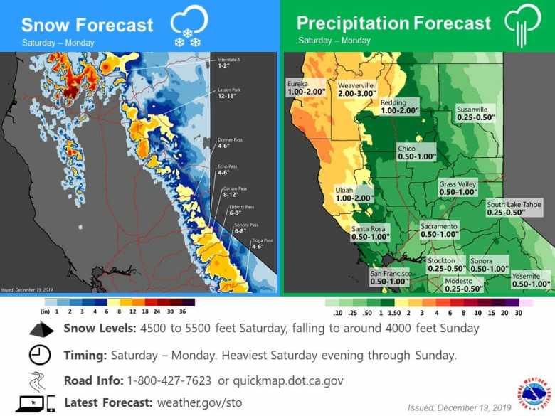
The dry weather is expected to hold across much of the area into Saturday as the offshore trough digs, slowing the eastward progression of the cold front as it becomes more north to south oriented with time. Precipitation will likely spread into the western zones by late Saturday before spreading east across the remainder of interior NorCal on Saturday night and Sunday.
Accumulating snowfall will develop across the northern Sierra Sunday morning leading to an increasing risk of travel impacts by the afternoon. Snow levels will be around 4500 to 5500 feet. A winter weather advisory is in effect. Precipitation becomes more showery Sunday as the upper trough shifts overhead.
Extended Discussion (Tuesday through Friday)
With the slow moving weekend system near the vicinity of Baja California early Tuesday, a progressive shortwave ridge races through favoring a brief period of dry weather. Precipitation returns to the picture by late Tuesday as another system is primed to sweep through as shown by deterministic/ensemble models. With a myriad of solutions portrayed by ensemble members, forecast uncertainty is on the higher end regarding rain/snow amounts. Snow levels for Christmas Day will likely be on the lower side given cool temperatures aloft (-10 to -12C at 700 mb), roughly in the 2,500 to 3,500 foot range. 24-hour probabilities for a variety of QPF thresholds are not the most enthusiastic about this system. The heaviest amounts are expected along the coast and down toward southern California. However, this system does bear watching given the low snow levels and impacts on any holiday travel.
Looking further ahead, the wave train of systems to affect the West Coast continues for late in the week. The guidance continues to bounce around with the position of the next upper trough, particularly the more unstable deterministic runs. Snow levels do remain low like the preceding system. Overall, this wet pattern is consistent with what is advertised by the Climate Prediction Center Day 6-10 (December 25-29) precipitation outlook.