October 15, 2016 – Additional Pacific storms will bring periods of rain (heavy at times), gusty wind, and high mountain snow into early next week. Drier with warming temperatures expected midweek.
Discussion
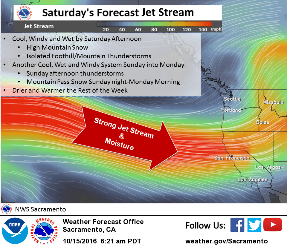
First wave in a series of Pacific storms is exiting the area with 88D showing a few lingering light showers over the mountains. Next developing Pacific frontal system is approaching the forecast area. Models show strong cyclogenesis offshore today as 983 MB surface low deepens to around 971 MB this afternoon as it nears the Washington Coast. Associated frontal system spreads another round of widespread precipitation and gusty wind across interior NorCal this afternoon into tonight. Precipitation amounts however look somewhat limited in the Central Valley due to rain shadowing off the Coastal mountains in cross barrier flow. Main bulk of precipitation is expected over the foothills and mountains. Low level strong southerly flow will provide orographic enhancement into the Shasta mountains and moist mid level orographic flow will increase precipitation amounts over the Western Plumas mountains and Sierra Nevada. Precipitation amounts of 1 to 3 inches are possible for portions of these mountains through Sunday morning. Snow levels are expected to remain above pass levels through early Sunday.
Some afternoon to early evening instability today depicted over the northern and northwest foothills and mountains and in the Northern and Central Sacramento Valley to support isolated thunderstorms. Bufkit showing limited CAPE, below 300 J/KG in the Northern Sac Valley, while HRRR indicating higher values over Shasta county early evening. Bufkit shear profiles are strong for both 0-1 KM and 0-6 KM with helicity values exceeding 400 to support rotating updrafts.
Pressure gradients are tightening this morning ahead of approaching baroclinic zone. KRDD-KSAC surface pressure gradient currently over 4 MB and rising. Southerly winds of 20 to 35 mph with gust to 50 mph or more are expected in the portions of the Sacramento Valley, foothills and mountains. Strongest winds are expected this afternoon into early evening. GFS MOS guidance showing stronger wind than NAM and suggests potential for advisory speeds farther south in the Central Valley. Will continue to monitor this.
Precipitation turns showers Sunday behind front with bulk of precip expected in the foothills and mountains. Snow levels will be fairly high above pass levels during the day Sunday but could drop to around 7000-7500 feet in heavier showers tomorrow with light snow accumulation possible at the major pass levels, including Donner Pass on I80 and Echo Summit on Highway 50. Lassen Park and higher elevations passes such as Carson Pass, Ebbetts Pass and Sonora Pass could receive more significant amounts of snow impacting travel, especially later Sunday. If significant precipitation continues Sunday night into early Monday, dropping snow levels (~6500 feet) could bring the possibility of travel impacts to the major passes. Will watch future model runs to see if a Winter Weather Advisory for early season snow may be warranted. Instability Sunday afternoon looks significant to support isolated thunderstorms, with highest CAPE values depicted over the Northern and Central Sacramento Valley extended east into the foothills and mountains.
GEFS/GFS showing integrated water vapor transport decreasing over Interior NorCal Monday with models indicating main threat of light showers confined to the foothills and mountains. Heights increase offshore Tuesday and build inland decreasing threat of precip to just a slight chance over the Shasta mountains. AMS begins to warm Tuesday under increasing subsidence.
Extended discussion (Wednesday through Saturday)
High pressure builds over the west coast on Wednesday bringing dry conditions, light northerly winds, and warmer temperatures although still a few degrees below normal for this time of year. The upper ridge axis moves across the state Thursday and Friday bringing warmest days of the week with highs right around normal for mid October. Upper ridge shifts east of the state by next weekend bringing a turn to southwest flow aloft and a slight cooling trend. High pressure will however continue to hold any precipitation north of the forecast area so extended forecast remains dry.