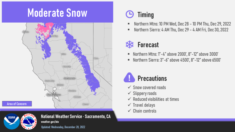
Mostly dry conditions expected today, then the active storm pattern returns with multiple rounds of precipitation expected through the rest of the week and into next week. Prolonged series of wet storms with fluctuating snow levels into next week.

Discussion
Skies have cleared out in the wake of yesterday’s storm allowing the development of fog and low clouds in some areas. Current temperatures are running around 5-10 degrees cooler compared to 24 hours ago and most valley areas are at or near saturation. Modesto, Mather and Red Bluff are all reporting 1/4 mile visibility or less and IR difference imagery is showing fog/low cloud areas slowly expanding, so a Dense Fog Advisory has been posted for the Central Valley until 11 AM.
Besides a few lingering snow showers over the high Sierra early this morning, interior NorCal will see a break from precipitation today allowing creeks and streams a chance to recede. The break won’t be long as the next system will spread precipitation back into the region overnight tonight beginning an extended stretch of wet weather that will last into the weekend.

Initially, precipitation won’t be as much as what we saw early in the week with lighter amounts expected through Thursday (0.5 to 1.5 inches in the valley and 1.5 to 3 inches in the foothills and mountains).

Snow levels will be lower resulting in impacts to travel across the northern mountains and northern Sierra where Winter Weather Advisories have been posted.

Precipitation is forecast to increase across the area Friday and Saturday as a couple waves move across the region with increasing IVT (periods of moderate to high). Heavier QPF is forecast with 2-3 inches in the valley and 3-6 inches in the foothills and mountains, and a large area of 7-9 inches in the orographically favored west slopes of the northern Sierra.

Snow levels will be above the pass levels through much of the event, but will lower Saturday as stronger short-wave trough moves in. Mountain travel impacts will likely be less heading into the weekend, but will deteriorate Saturday.

However, the widespread moderate to heavy precipitation will result in increased flows in creeks and small rivers, and minor flooding will be possible.
Southerly wind will pick up again beginning Thursday, but at this point looks to be considerably less than Monday night and Tuesday’s wind event.
Extended Discussion (Sunday through Wednesday)
A brief lull in the wet pattern is expected Sunday with an upper level ridge bringing dry weather with some breezy north winds. Cluster analysis shows a shift to a moist southwest pattern, though, for next week.
A series of systems bring the potential for more rain and mountain snow next week, with the unsettled pattern continuing. Exact timing remains uncertain, but confidence is high in a generally wet pattern continuing. While these storms don’t look as wet or as strong as the recent event, cold air should bring lower snow levels next week and winter travel problems could be an issue at times.
