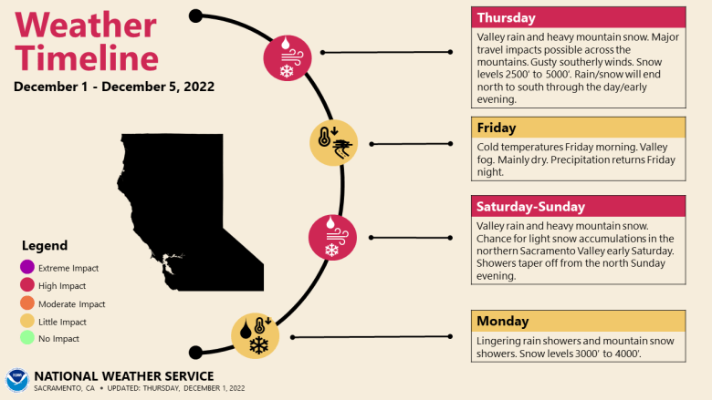
A strong winter storm today with heavy mountain snow followed by a second winter storm and more heavy snow over the weekend. Cold and dry weather returns next week.

Discussion
Storm system is moving into the region this morning. Snow levels are expected to drop first over Shasta County early this morning then for the western slopes late this morning through early this evening as the storm transitions south. The bulk of the storm will pass Shasta county this morning with only some residual showers possible later during the day. For Plumas County the heaviest snow is expected this morning into early afternoon while further south late this morning through early evening.


Rainfall amounts for the valley look to be between a half inch to an inch of rain while the mountains and foothills should mostly range between one and three inches of rainfall.

Gusty winds this morning as the front moves through with gusts up to 45 mph over the north end of the valley early. As the storm moves south winds will increase after around 4 am for the Sacramento region with gusts potentially between 35 and 45 mph for 1 to 2 hours as the storm moves through later in the morning. By afternoon the winds will be decreasing.
The storm will push south and east tonight and set up for a cold morning on Friday with temperatures lowering into the upper 20s to lower 30s in the valley and teens and 20s for the mountains with some of the colder mountain valley lowering into the single digits.
There will also be the potential for some fog developing Friday morning from around the Sacramento region southward.
The next system looks to start to move into the region on Saturday and Sunday. A storm system dropping south from the Gulf of Alaska currently looks like it may absorb some moisture from the southwest into the region Saturday bring the potential for some precipitation.

The main part of the system will move into the region on Saturday night into Sunday. Snow levels look to be a little bit higher with this system as warmer air advects into the region during the day on Saturday ahead of the main storm but lower to 3000 to 4000 feet on Sunday. Similar amounts of rain and higher elevation snow look possible with this system as compared with the current one.

Extended Discussion (Monday through Thursday)
There is the potential for some lingering showers on Monday but generally we should be drying out. NBM is probably overstating the chances of precipitation at this point. After Monday clusters keep a trough pattern over the west but models are indicating a dry pattern Tuesday through Thursday. Cold mornings in the valley with 30s forecasted with teens and 20s for the mountains. Still a lot of uncertainty Thursday night and Friday with a potential system approaching the area. Temperatures generally look to be below normal for this time period.
