Dry weather expected through Saturday. Precipitation chances return Saturday night and Sunday with several inches of snow possible at pass levels. Another stronger storm possible next week. This will bring more Valley rain, heavy mountain snow and gusty winds.

Discussion
Short wave ridge over NorCal will remain in control of the weather through Saturday afternoon. This will provide dry weather, light winds and mild temperatures. The exception will be an isolated shower or two along the Sierra crest in Tuolumne/Alpine counties.
Temperatures will warm to near seasonal averages today and Saturday with highs in the mid and upper 60’s and lows from the low to upper 40’s.
After the much needed break the next couple days, a modest shortwave will subtly amplify the mid-level flow from the Pacific to provide a favorable overlap of moisture and ascent to spread precipitation back onshore into California.
This shortwave is progged to lift into CA Sunday morning with modest height falls and a subtle backing of 850-700mb flow to the SW. This will be accompanied by the approach of an extensive and NW to SE oriented Pacific jet streak reaching 110-130 kts, collocated with the best mid-level height falls.

This will have the dual effect of providing large scale ascent to the region, while also increasing moisture noted by modest probabilities according to CW3E of IVT exceeding 250 kg/m-s by late Sunday.

Snow levels within the most intense WAA spreading into the Sierra will rise to around 6000 ft, but will otherwise be generally be near 5000 ft, and WPC probabilities for more than 6 inches of snow are above 60% along much of the Sierra, and 20-30% in the Shasta/Trinity region.

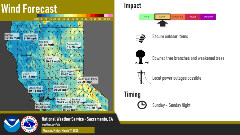
South winds will also increase to at least breezy levels with gusts 25-30 mph up the Valley Sunday and Sunday night.
System taking shape over the Gulf Alaska will push more significant moisture into the area late Monday into Tuesday.

Snow levels are likely to fall into 4500-5000 foot range Monday night with several more inches of snow possible heaviest Monday night Tuesday. Rainfall amounts Sat night-Sunday look to be 0.25-0.75 quarter of inch in the Valley and 0.50-1.50 foothills and mountains.
Additional liquid amounts could approach an inch over the foothills and mountains Monday and Monday night.
Extended Discussion (Tuesday through Friday)
Longwave wave trough continues along the West Coast Tuesday as embedded short wave taps into northern portions of a weak to moderate AR focused into Central/Southern CA.

As a result, heavier precipitation expected over southern portions of the CWA with heavy snow continuing in the Sierra Nevada. Showers continue Wednesday as trough axis progresses through.
Decreasing shower threat Wednesday night into early Thursday under short wave ridging.
Next Pacific frontal system spreads more precipitation in from the NW Thursday afternoon and over the entire CWA overnight into Friday.
