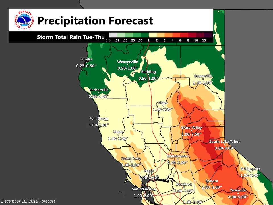
December 10, 2016 – Wet weather through this evening. Periods of wet weather likely to continue next week, with significant mountain snow possible Tuesday to Thursday. More precipitation is coming along this atmospheric river Tuesday through Thursday. This period looks more like a hybrid of warmer subtropical moisture Tuesday and colder air coming late Wednesday and Thursday.
Update discussion
A very moist plume of Pacific moisture continues to bring widespread light precipitation to the valley and more moderate to heavy precipitation over the mountains. As of 1000am PST, the mountains 2-4 inches of rain with the heaviest amounts from Nevada County up through eastern Butte and western Plumas counties. More is expected today valley precipitation winding down this afternoon up north and not until mid to late evening for the Sacramento and Modesto, respectively, as the moisture plume shifts southward and drier air moves in.
Snow levels with this warm event are quite high this morning, over 9000 feet. This will keep snow accumulation from being an issue except over high peaks today.
Models are shaping up for a very wet period from Tuesday through Thursday with moderate snow levels (4000 to 6000 ft from north to south).
Extended discussion (Wednesday through Saturday)
Moisture tap from the subtropics into northern California continues into the extended period. GFS and ECMWF both showing precipitation over the entire CWA on Wednesday. Slight ridging over the southwest U.S. should bring moderately high snow levels. Upper shortwave trough dropping into norcal on Thursday will keep precipitation going on Thursday. Moderate precipitation will be possible over the higher elevations where orographics play a role.
Models show main upper trough digging into the Great Basin on Friday bringing northerly flow aloft to the north state. This northerly flow should bring drying but norcal remains under cyclonic flow so some light precipitation may be possible in moist airmass. At this time, all extended models bring drying next Saturday. Have therefore kept end of extended period dry with clearer skies but cool northerly flow will keep daytime high temperatures below normal.