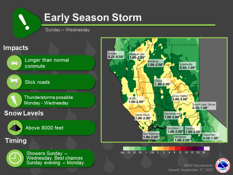
Cooling trend through this weekend with below normal temperatures continuing next week. Widespread shower chances late Saturday into early next week with possible afternoon thunderstorms. Smoke from the Mosquito Fire could bring locally low visibility Sunday morning.

Discussion
Long wave trough along the West Coast as 553 DM low over B.C. digs into it over the weekend. Low center progged off the far NorCal coast by 00z Sun. Increasing clouds and synoptic cooling from the NW today with approaching low will result in high temperatures upwards of 10 degrees cooler over Friday.

Threat of associated showers over the Coastal Range and portions of Shasta county this evening. Potential for more widespread precip over interior NorCal Sunday as upper low moves to west of KUKI and deepens. GEFS Ensemble mean IWVT progs show low tapping into higher PW plume and directing the plume into NorCal beginning tomorrow.

Models suggest precip threat spreading from NW to SE over the CWA Sunday but differ on rate of eastward extent. NAM keeps main precip from about I-5 west through Monday morning while GFS/EC spread precip to Sierra Nevada Sunday night into Monday morning. NBM showing much cooler highs expected tomorrow with 60s to low 70s for the Central Valley and upper 40s to mid 60s for the mountains and foothills.
Snow levels Sunday remain generally above 7500 to 8000 feet. Low continues to drop slowly south off the CA coast Monday, moving to west of the Bay area by the afternoon.

Potential for heavier precip Monday with diffluent flow aloft and increased instability leading to possible afternoon/evening thunderstorms. Snow levels expected generally above 8500 feet Monday.
Highs in the upper 60s to lower 70s for the Central Valley. Models differ with progression of low, but ensembles suggest it remaining quasi-stationary, west of the Bay Area, Tuesday with a continued threat of showers and afternoon thunderstorms. Slight warming expected Tuesday but continued below normal temperatures.
Extended Discussion (Wednesday through Saturday)
Clusters continue to slow down ejecting upper low eastward on Wednesday and will continue the NBM PoPs for this timeframe. Some instability remains Wednesday which may lead to isolated thunderstorms. Low should finally move out Thursday and Friday with a drying trend and temperatures warming back to near or slightly below normal.
