An extended period of dangerous heat is expected for most of this week. Well above normal temperatures are expected to continue each day through the middle of next week, with the most significant heat forecast for Sunday through Wednesday. Monsoon moisture could push into the Sierra bringing ~5-15% chance of thunderstorms south of Highway 50 Wednesday into the weekend.

Discussion
Strong ridge of high pressure is building back in over Northern California after the trough that dimmed yesterday’s temperatures has moved to the northeast. Ensembles in strong agreement that the ridge will continue to strengthen over the next few days, with temperatures rising significantly.
Daytime temperatures today are forecast to peak around 104 to 108 degrees in the Valley, 95 to 105 degrees in the foothills, and upper 70s to low 100s in the mountains. Temperatures will rise another 2 to 5 degrees Monday and again another few degrees in most locations on Tuesday.
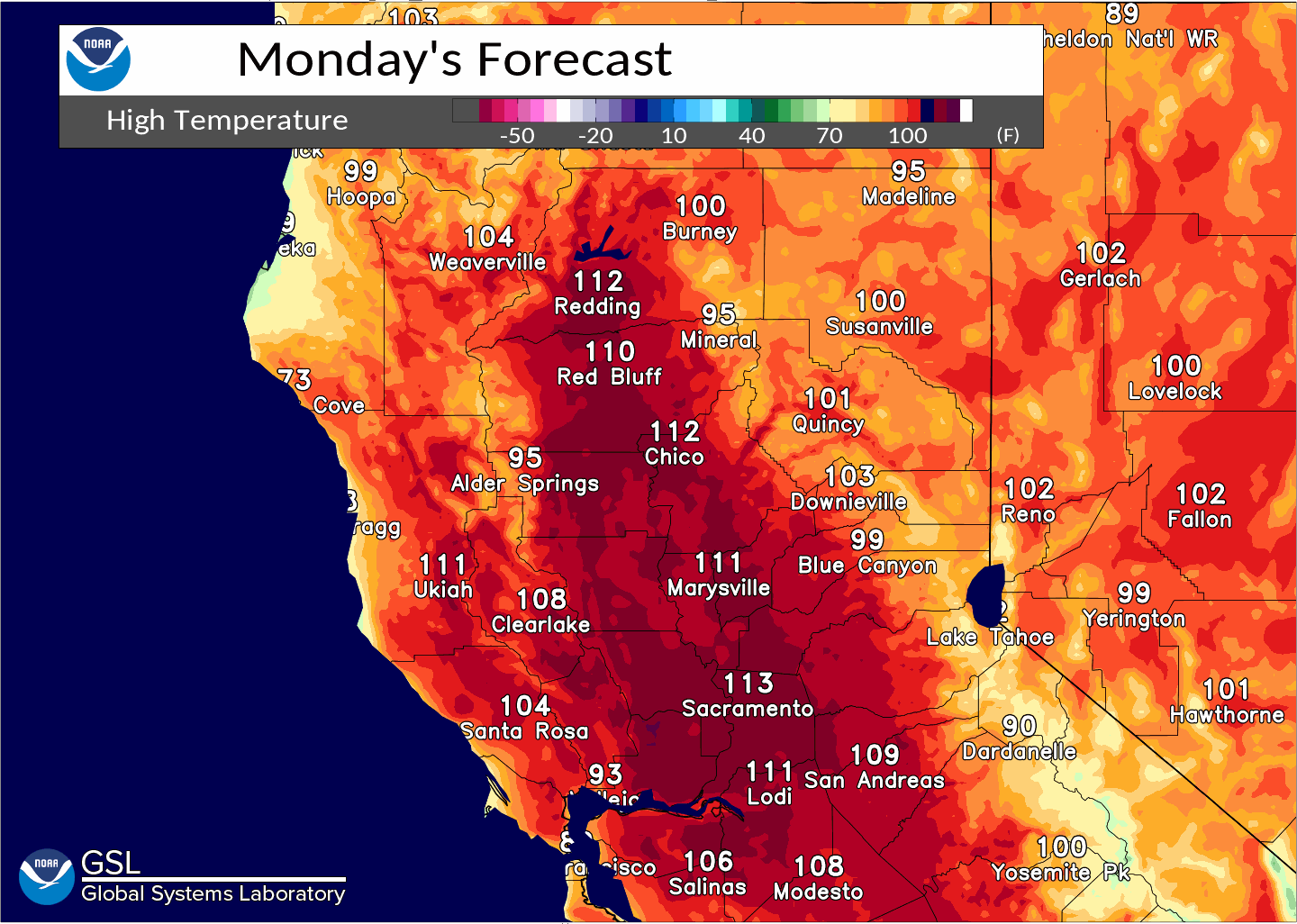
Widespread temperatures near 110 to 115 degrees are now forecast across the Valley Monday through Wednesday as ensembles keep the ridge firmly in place over the West. 850 mb temperatures are forecast to peak around 30 to 33 degrees Celsius Monday through Wednesday, and EFI has strengthen the anomalous heat to near record for this time period.
Many locations will be nearing or exceeding multiple temperature records, including daily, all- time September, and overall all- time high temperature records.
Also, consecutive 110+ degree day records could be neared or broken this week, including for Downtown Sacramento and Sacramento Executive Airport.

Overnight temperatures will provide no relief for most locations except for the higher mountain locations. Expect morning lows to not fall below the 70s with forecasts in the low 70s to mid 80s for Valley and foothill locations. This heat will be dangerous to the general public with widespread high to very high heat risk forecast.

An Excessive Heat Warning remains in effect Sunday through Wednesday. These temperatures increase the chance of heat- related illness for the general population, especially those who are sensitive to the heat, have outdoor plans, or do not have air conditioned homes. Drink plenty of water, seek air conditioning, and learn the symptoms of excessive heat exposure.

One caveat for the temperature forecast this week is potential smoke inundation from wildfires in Siskiyou County. Weak northerly winds through the forecast period could bring wildfire smoke into the forecast area. If the smoke is thick enough as it moves south, it could affect the temperatures this week. At this point, HRRR smoke is indicating it does not look like this will occur through Monday, but we will need to keep an eye on how the wildfires progress.
Monsoon moisture will make a push back into the Central Sierra beginning Wednesday. This could bring about a 5-15% chance of isolated showers and thunderstorms to the high Sierra south of Highway 50. It could also dampen temperatures slightly over this region.
Extended Discussion (Thursday through Sunday)
Ensemble guidance now indicating high pressure will remain over California through at least Thursday and likely into Friday, which is backed up by the latest cluster analysis (00z Sunday run). The incoming trough has been weakened and will likely pass north of the strong ridge, grazing the PacNW into the intermountain West. This would lower heights slightly over Northern California Thursday and a bit more on Friday.
Latest forecast keeps dangerously hot temperatures on Thursday, similar to or only a couple of degrees cooler than Wednesday. EFI has extended the period of anomalous temperatures over the area into Thursday, as well. Temperature forecast for Friday has also increased from previous forecasts, though they are expected to be cooler than previous days with Valley highs around 103 to 109 degrees.
The forecast becomes much more uncertain over the weekend. Temperatures are forecast to finally cool quite significantly back to near normal by Sunday.
Models are picking up on the possibility of tropical storm moisture being pulled into the monsoon high and advected north into Northern California this weekend. This could produce a chance of high based showers and thunderstorms across portions of interior Northern California, and NBM has introduced slight precipitation chances through most of the Sierra into the Valley on Sunday.
Confidence in this is extremely low as the tropical storm in question has not even formed yet in the Pacific.
However, we will definitely be watching this close as lightning following the significant heat event could produce fire weather concerns.