Happening Now brings community news, updates and announcements throughout the day. You are invited to participate. See a road closure? A smoke plume? Weather-related mishap? Email us at news@yubanet.com or call 530-478-9600. Or text 530-409-9888, but please don’t text or call while driving.
October 31, 2020 at 7:41 PM Units are at scene on Dorsey, reporting no fire. Construction work only, soldering a pipe. All units are being canceled.
October 31, 2020 at 7:36 PM Reported smoke in an apartment on Dorsey Drive, units are in route.
October 31, 2020 at 3:33 PM Daylight Saving Time ends tonight, chance of rain next weekend. Sunny skies and dry weather continue across interior NorCal this Halloween weekend. Don’t forget to turn your clocks back one hour before you go to bed tonight! Daylight Saving Time ends at 2 am tomorrow morning. This is also a good time to check the batteries in your smoke & carbon monoxide detectors & NOAA Weather Radio!
October 31, 2020 at 2:42 PM
October 31, 2020 at 1:00 PM Unscheduled political drive-through demonstration in Nevada City, with rapid pedestrian response. Avoid Hwy 49 and downtown Nevada City as cars are clogging up the roadway.


October 31, 2020 at 12:25 PM Vehicle into a creek on North Bloomfield Road between Wet Hill and Hwy 49, the roadway is partially blocked. Traffic control is in place.
October 31, 2020 at 12:12 PM A group of cars, associated with a political rally, are speeding up then slowing down as a group on Hwy 49 near Wolf Road. Use caution in the area.
October 31, 2020 at 10:45 AM
October 30, 2020 at 7:36 PM Nevada County COVID-19 update: 7 new cases and one additional fatality reported today for a total of 642 confirmed cases.

October 30, 2020 at 12:51 PM Accident on Mooney Flat Road near Pleasant Valley Road. Reported as a solo vehicle accident, driver is out of the car. Units are in route.
October 30, 2020 at 9:19 AM
October 30, 2020 at 8:38 AM Reported fire on hillside at Sunrise Ridge Circle south of Auburn. Units in route.
October 30, 2020 at 7:01 AM Above average highs and still very dry. A warm and dry Halloween weekend in store. Also, clocks fall back 1 hour on Sunday morning as we transition from Daylight Time to Standard Time. It’s also a good time to check and make sure the batteries in your smoke detectors & NOAA Weather Radio are functioning.
October 29, 2020 at 3:50 PM Nevada County COVID-19 update.

October 29, 2020 at 11:56 AM Accident on Hwy 174 near Greenhorn Access Road, roadway is blocked and units are at scene.
October 29, 2020 at 9:34 AM
October 29, 2020 at 8:12 AM Dry weather and above normal temperatures are on tap for today. Overnight low temperatures will cool to near normal readings in the mid and upper 40’s each night.
October 28, 2020 at 8:15 PM First unit on Chaparral reports only possible minor injuries, one medic to continue, all others can cancel.
October 28, 2020 at 8:07 PM Vehicle rollover, extrication required, Chaparral Circle in Penn Valley. Numerous units in route.
October 28, 2020 at 2:07 PM
October 28, 2020 at 1:09 PM Possible accident on Lowell Hill Road near Rd Dog. Car in the trees with hood up and windows open. Could be a previous collision.
October 28, 2020 at 8:14 AM Warming up, no rain in sight. Warm and dry weather with lighter winds is expected across the region today. Locally gusty winds will continue across the higher elevations of the northern Sierra Nevada this morning, otherwise lighter winds are expected across the region today.

October 27, 2020 at 11:19 PM Banner Quaker Hill area of Nevada City, have you seen this dog?
Charlie and his humans are visiting a friend in Nevada City. When the power came back on, Charlie escaped through the garage door out of the house.
He is wearing his collar and tags from Las Vegas.
If you see Charlie, please contact Johnny at 530-687-2324.
October 27, 2020 at 5:08 PM Nevada County COVID-19 update

October 27, 2020 at 4:57 PM Traffic lights are out in the Brunswick Basin as the switch back to utility power is in progress. Please use extreme caution and treat each non-functioning traffic light as a stop sign!
October 27, 2020 at 12:45 PM Pleasant IC reports a faulty stove, not a structure fire. One engine to remain at scene with the IC, all others can cancel.
October 27, 2020 at 12:41 PM Possible residential structure fire on Pleasant Street, numerous units responding. The home has been evacuated.
October 27, 2020 at 11:46 AM All aircraft are returning to Grass Valley, ground resources have contained the car fire.
October 27, 2020 at 11:35 AM No smoke visible on the cameras in the Smartsville area. Units are at scene, including air support.
October 27, 2020 at 11:23 AM Vehicle vs pedestrian on Lower Colfax Road near Karry’s Place. Units are at scene, air ambulance on order.
October 27, 2020 at 11:19 AM Reported vegetation fire caused by a car fire on Hammonton Road in Smartsville, full wildland response on order.
October 27, 2020 at 10:53 AM Several helicopters are inspecting power lines in Nevada County. These low-flying ships are part of the restoration process.
October 27, 2020 at 9:55 AM
October 27, 2020 at 6:52 AM Decreasing winds today, fire danger remains high. A wind advisory remains in effect for the higher elevations of the southern Cascade Range and northern Sierra Nevada until 2 PM this afternoon.
October 26, 2020 at 5:28 PM

October 26, 2020 at 5:23 PM The Dowd Fire near Sheridan is 100% contained. CAL FIRE/ Placer County Fire Department firefighters will continue to check. Cause of the 56 acre fire determined to be farm equipment. Waltz Road and North Dowd Road in rural Placer County. Assisted by Lincoln City Fire and Wheatland Fire.
October 26, 2020 at 4:34 PM With better mapping, the Dowd Fire off North Dowd Rd and Waltz Road South of Sheridan in Placer County is 56 acres and 50% contained.
October 26, 2020 at 4:16 PM Accident on Hwy 49 at the Gold Flat on ramp, units are at scene.
October 26, 2020 at 3:09 PM The Dowd Fire is now reported at 100 acres.
October 26, 2020 at 2:54 PM Reported fire in a yard on Auburn Folsom Road in south Placer. Full wildland response dispatched.
October 26, 2020 at 2:00 PM Rice field on fire on Waltz Road and Dowd Road south of Sheridan in Placer County. Units are at scene.
October 26, 2020 at 9:44 AM
October 26, 2020 at 9:18 AM From a reader: Two black and brown German Shepherds are here at our property on Indian Flat Road. One short-haired and the other long-haired. They are friendly with humans, but maybe not with other dogs. They don’t have tags except Nevada County tags. Due to other dogs on property, these dogs aren’t being confined, so they could wander off. We hope to find the owners asap. Editor’s note: Contact us via phone or text and we’ll pass the message along.
October 26, 2020 at 7:52 AM Report of a stove fire, structure is filled with smoke, in Alta Sierra on Scott Way near Norlene Way. Units in Route.
October 26, 2020 at 7:17 AM Units in the area of the fire visible from the Bald Mountain and Bunker Hill cams are requesting aircraft. Reporting some spotting. This will be the Point Fire, updates will be posted here: https://yubanet.com/regional-fires/point/

October 26, 2020 at 7:03 AM Report of dark grey smoke seen near the Foresthill Bridge in Auburn. Could be this new start seen on the Bald Mountain cam.

October 26, 2020 at 6:10 AM Red Flag Warning extended through Tuesday. Critical fire weather conditions continue across the area due to the gusty winds, very low RH, and record dry fuels. Despite these conditions, fortunately IR difference imagery is not indicating any new significant fire starts across interior NorCal overnight.
October 26, 2020 at 4:30 AM
October 25, 2020 at 9:16 PM All units on the debris check are being canceled, false alarm.
October 25, 2020 at 9:10 PM Units in the area of Peardon found one home with a briquette BBQ, but no fire. They will continue to search.
October 25, 2020 at 8:56 PM Reported debris fire, possible bon fire, on Peardon Road off Logue Lane near Mooney Flat.
October 25, 2020 at 8:44 PM Tree into power lines, lines not on the ground in the area of Amber Lane in Browns Valley. Units dispatched. No fire reported at this time.
October 25, 2020 at 7:06 PM Firefighters are have conducted several smoke checks for reported debris fires and smell of smoke all throughout western Nevada County. So far, no fires located. Let’s keep it that way!
October 25, 2020 at 3:17 PM The National Weather Service has extended the Red Flag Warning until Tuesday at 5:00 pm.
October 25, 2020 at 1:59 PM Thanks to reader Karen for sharing the photo. “Hillagains Running Group voting before our run on Sunday morning October 25, 2020. RUNNING TO VOTE EARLY!”

October 25, 2020 at 1:58 PM Air and ground ambulances are transporting patients from the accident on HWY 20 to a Roseville trauma center.
October 25, 2020 at 1:24 PM Units at scene on Hwy 20 report a total of 5 patients, requesting a second ground ambulance.
October 25, 2020 at 1:21 PM Accident on Hwy 20 near the Five Mile House, reported as a vehicle rollover. Units are almost at scene.
October 25, 2020 at 11:43 AM According to Union Hill Superintendent Andy Parsons: As of right now, due to PSPS today, Monday and Tuesday we will be closed to students. If the PSPS does not happen, Parsons will send a message to all families early in the morning.
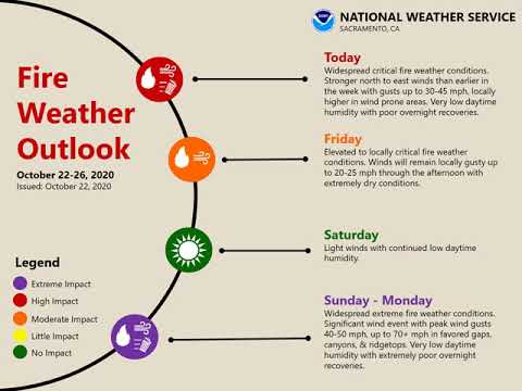
October 25, 2020 at 11:03 AM Extreme Fire Weather Conditions through Monday night, critical fire weather expected Tuesday. The Storm Prediction Center has a large portion of the region under an “extremely critical” risk, the highest possible categorical assignment for fire weather. Fuels are dry and will only further dry, winds and gusts will be very strong, and relative humidity values will be desert-dry. The meteorological synoptic setup is uncomfortably similar to recent past events in northern California such as October 27-28, 2019 (Kincade Fire rapid growth), November 8, 2018 (Camp Fire rapid growth), and October 8-9, 2017 (2017 Wind Complex and Wine Country Fires rapid growth).
October 24, 2020 at 10:29 PM
October 24, 2020 at 12:00 PM Extreme Fire Weather Conditions Sunday Through Early Tuesday Morning. Quiet weather is forecast for today; however, it will be short lived as the weather pattern changes. An area of low pressure is forecast to slide into the desert southwest Sunday into Monday, which will bring extreme fire weather conditions to most of northern California. Compared to other events, this looks to be the strongest wind event of the year so far. Winds will gradually decrease throughout the day on Tuesday as the low slides farther east. Conditions look to become more pleasant by Wednesday; however, there may still be some residual light north and east winds.
October 23, 2020 at 6:02 PM PSPS #5: 38 counties and 466,087 customers could be affected by the PSPS, according to the first, preliminary list released by PG&E.
October 23, 2020 at 3:10 PM
October 23, 2020 at 2:59 PM The National Weather Service in Sacramento has issued a Red Flag Warning, which is in effect from 8 PM Sunday to 1 PM PDT Tuesday. The Fire Weather Watch is no longer in effect.
October 23, 2020 at 1:22 PM Power has been restored in the Peardale area.
October 23, 2020 at 12:38 PM
October 23, 2020 at 11:04 AM 2,136 customers impacted by the outage – preliminary estimate of restoration is 1:45 pm. The preliminary restoration times are automatically calculated by the PG&E system.

October 23, 2020 at 10:58 AM Power outage in the Peardale area – unknown extent or cause.
October 23, 2020 at 10:53 AM PG&E Meteorology is actively tracking the potential for widespread gusty and damaging winds across California Sunday into Tuesday. Zones 1-6 and 8 are now in PSPS Watch Sunday through Tuesday and Zone 9 Monday and Tuesday. The areas with the highest probability of being affected by PSPS for next event are the adjacent terrain of the northern and western Sacramento Valley, Northern and Central Sierra, as well as higher terrain of the Bay Area, including the Santa Cruz Mountains, Central Coast Region and portions of southern Kern.

October 23, 2020 at 10:22 AM Lingering fire weather concerns today, becoming extreme Sunday through Monday. Gusty winds with low humidity and record dry fuels will continue to bring critical fire weather conditions into this afternoon. Cool temperatures expected this weekend as a cold system moves into the Great Basin, with a few light showers in the Sierra south of I-80 Sunday afternoon. This system will bring a very strong north/downslope drying wind event and critical to potentially extreme fire weather conditions across Northern and Central California Sunday into early Tuesday. This looks to be the strongest fire weather event of the year so far with extremely poor humidity recovery and powerful wind gusts over ridges and northeast oriented canyons. We will update the forecast as conditions change.

October 23, 2020 at 8:53 AM With leaves coming down, it’s easier to spot Diva, a red-shouldered hawk, patiently waiting to catch a breakfast snack.

October 22, 2020 at 5:58 PM Live Town hall: Overdoses in Nevada County

October 22, 2020 at 4:45 PM Marysville Air Attack has released the helicopter and is leaving the incident. The fire is holding at 1.5 to 2 acres, firefighters are starting mop-up operations.

October 22, 2020 at 4:43 PM Nevada County COVID-19 stats for the day.

October 22, 2020 at 4:40 PM Firefighters are making good progress, threat to structures has been mitigated.
October 22, 2020 at 4:35 PM Marysville Air Attack is releasing both tankers back to Grass Valley. A helicopter will work hotspots and assist the ground resources.
October 22, 2020 at 4:27 PM Air Attack 230 reports good progress on the heel of the fire. Still some open flame on the Marysville Road side. A dozer is working the area.
October 22, 2020 at 4:21 PM Now a full wildland dispatch for the fire on Willow Glenn and Marysville Road. Units are on scene. Reportedly, there are multiple spots caused by a vehicle with a trailer causing sparks.

October 22, 2020 at 4:16 PM Fire along Willow Glenn Road in front of Ace Hardware store in Yuba County.

October 22, 2020 at 3:44 PM The first details of a potential widespread PSPS event for Sunday through Tuesday. Per PG&E: “PG&E Meteorology is actively monitoring the current Diablo wind event as well as the potential for a significant offshore wind event to unfold later this weekend and into early next week. The PSPS potential forecast has been updated to show Elevated status for multiple Zones between Sunday and Tuesday. At this time, the event appears to be much stronger and more widespread than the current event with the highest probability of PSPS encompassing areas and adjacent terrain of the northern and western Sacramento Valley, Northern and Central Sierra as well as higher terrain of the Bay Area, including the Santa Cruz Mountains, Central Coast Region and portions of southern Kern. The start of the event is more than 3 days away so event details will likely change as forecast models evolve. We will have more clarity on potential cities and counties impacted in the next 24-48 hours.”

October 22, 2020 at 2:51 PM Ferry Fire in Oroville, off Old Ferry Road and Linden Street. The fire is holding at 10 acres, according to the latest update from Oroville FD. Evacuations and road closures are in effect. There is still a threat to structures but firefighters are making good progress.

October 22, 2020 at 2:18 PM
October 22, 2020 at 2:23 PM Sharing with you the latest video briefing by the National Weather Service in Sacramento. We will be monitoring the updated models and forecasts very closely and keep you posted. As it stands right now, this could be the strongest wind event of the year. Please prepare now.
October 22, 2020 at 1:39 PM Reported 5-10 acres of rice fields and equipment fire on Matthews Lane near Hwy 70, Yuba County. Numerous units being dispatched.

October 22, 2020 at 11:50 AM Reported burn pile on Wolf Road near Hwy 49. No Burn restrictions are in effect. Units are en route. CAL FIRE is requesting law enforcement to respond.
October 22, 2020 at 11:01 AM
October 22, 2020 at 10:40 AM Critical fire weather conditions through Friday, becoming Extreme Sunday through Monday. Gusty winds with low humidity and record dry fuels will continue to bring critical fire weather conditions through Friday afternoon. The strongest winds are expected through mid afternoon for the Valley, tonight for the mountains and foothills. Temperatures will cool to near or below normal by late this week. There is also the potential for a few light showers in the Sierra south of I-80 on Sunday as a cold system moves into the Great Basin. This system will bring a stronger, north/downslope drying wind event and critical to potentially extreme fire weather conditions across Northern and Central California Sunday into early Tuesday. This looks to be the strongest fire weather event of the year so far, and will be closely monitored. We will update the forecast as conditions change.
October 22, 2020 at 9:32 AM
October 22, 2020 at 8:29 AM
October 22, 2020 at 7:56 AM
October 22, 2020 at 7:46 AM
October 21, 2020 at 4:14 PM Yuba and Lassen counties no longer in scope for PSPS, PG&E reports.
October 21, 2020 at 1:59 PM
October 21, 2020 at 12:53 PM Accident on westbound Hwy 49 at the Dorsey Drive on ramp. Units at scene.
October 21, 2020 at 10:39 AM Critical fire weather conditions this week into early next week. A progressive pattern continues to result in multiple periods of breezy north to east drying wind events through early next week. These weather conditions combined with record dry fuels will result in periods of elevated to critical fire weather conditions. Breezy winds will continue on the west side of the Valley into the Sierra foothills north of I-80 today. However, a renewed burst of stronger winds is expected after midnight tonight through Friday, resulting in prolonged critical fire weather conditions. Temperatures will cool to near or below normal by late this week, along with the potential of some light showers in the mountains this weekend. Very cold air is forecast to move into the Great Basin Sunday into next week. This is setting up the possibility for another, potentially stronger, north/downslope drying wind event and critical fire weather conditions across Northern and Central California. This pattern will be monitored, and we will update the forecast as conditions change.
October 21, 2020 at 7:45 AM
October 21, 2020 at 6:58 AM Car vs deer on Hwy 174 at North Meadow View Drive, the roadway is partially blocked. Use caution and reduce your speed in the area.
October 20, 2020 at 6:43 PM
October 20, 2020 at 6:04 PM
October 20, 2020 at 5:35 PM The latest Nevada County COVID-19 count.

October 20, 2020 at 1:05 PM Non-injury accident on Loma Rica Drive near Grass Valley Avenue, roadway is clear.
October 20, 2020 at 12:31 PM Car fire on Hwy 20 just west of Rough&Ready Hwy, reported as a semi with brakes on fire. Units en route.
October 20, 2020 at 11:51 AM Non-injury accident on the Brunswick overpass of Hwy 49. Units are at scene.
October 20, 2020 at 11:06 AM The latest wind gust forecast:

October 20, 2020 at 7:16 AM Red Flag Warning in effect through Wednesday morning. After a brief break in the winds during the day Wednesday, stronger winds return late Wednesday – Friday. A Fire Weather Watch has been issued.
October 19, 2020 at 6:12 PM PG&E preliminary plans call for no PSPS in Placer and Nevada Counties: While there is still uncertainty regarding the strength and timing of this weather wind event, the shutoff is forecasted to affect about 50,000 customers in targeted portions of 19 counties, including Alameda, Butte, Colusa, Contra Costa, Glenn, Humboldt, Lake, Lassen, Napa, Plumas, Santa Clara, Shasta, Solano, Sonoma, Stanislaus, Tehama, Trinity, Yolo and Yuba. A small number of customers in two tribal communities may also be affected.
October 19, 2020 at 4:45 PM

October 19, 2020 at 2:38 PM
October 19, 2020 at 12:52 PM The Fire Weather Watch has been upgraded to a Red Flag Warning.
October 19, 2020 at 11:25 AM Updated PG&E PSPS Watch: The PG&E Emergency Operations Center has been activated to prepare for a potential Diablo Wind event across Northern California Wednesday night through Friday morning. The 7-Day PSPS Potential Forecast has been updated and now includes PSPS Watch for Geographic Zones 1, 2, 3, 4, and 5. Please note that PSPS is not executed across entire Zones and much more detailed maps where PSPS is being considered will be provided as the event gets closer. This is only intended to provide a high level overview.

October 19, 2020 at 9:28 AM Smoke forecast from the NWS Sacramento.
October 19, 2020 at 7:54 AM Per PG&E: The 7 Day forecast has been upgraded to Elevated in Geographic Zones 2, 3, 4, and 5 across Northern CA as forecast confidence has increased in a Diablo wind event unfolding late Wednesday night through Friday morning. Please note that PSPS is not executed across entire Zones and much more detailed maps where PSPS is being considered will be provided as the event gets closer. This is only intended to provide a high level overview. PSPS decisions are made at more granular levels based on high resolution data; thus, only a portion of a zone may experience a PSPS event. At this time, the highest probability areas for observing a PSPS are in the Northern Sacramento Valley and adjacent elevated terrain, the Northern Sierra Nevada generally north of I-80, the North Bay mountains and near Mt. Diablo in the East Bay Area. At this time, the weather event is expected to begin Wednesday night and continue through Friday morning. The start of the event is more than 3 days away so event details will likely change as forecast models evolve. We will have more clarity on potential cities and counties impacted in the next 48 hours. Please stay tuned to future updates.

October 19, 2020 at 7:10 AM Fire Weather Watch tonight through Wednesday. Combination of low humidity with gusty north to east wind and dry fuels will likely result in critical fire weather conditions. Additional period of gusty wind and low humidity possible Wednesday into early Friday.
October 18, 2020 at 7:58 PM Reported accident on southbound Hwy 49 between Milhouse and Tyler Foote. Units en route.
October 18, 2020 at 3:33 PM Firefighters will be committed for several hours for extensive overhaul and mop up operations.
October 18, 2020 at 3:27 PM Additional resources are being released, all road closures remain in effect.
October 18, 2020 at 3:22 PM Hose lines are complete, firefighters are starting overhaul. There have been some civilian injuries reported, all patients have been seen by medics and transported to the hospital if warranted.
October 18, 2020 at 3:17 PM Incident Commander is starting to release some of the engines for coverage of the fire stations.

October 18, 2020 at 3:16 PM Fire activity has diminished, threat to adjacent structures has been mitigated, two structures have been lost.
October 18, 2020 at 3:10 PM Forest IC reports good progress, they should be able to handle with the units at scene.
October 18, 2020 at 3:08 PM All water tenders dispatched to the fire have arrived. Aircraft have been canceled. Forest Glade is closed to all traffic.
October 18, 2020 at 3:04 PM Forest IC is requesting PG&E to respond. Structure protection of neighboring homes is going well, no extension to other houses reported at this time.
October 18, 2020 at 3:01 PM Neighboring streets are reporting ash fall only, no embers. GVPD and partners are doing notifications to neighboring structures. Please avoid the area, road closures are coming. With progress being made, incoming Washington Ridge crews are being canceled.

October 18, 2020 at 3:00 PM Firefighters are working structure protection to prevent the fire from spreading to adjacent houses.
October 18, 2020 at 2:57 PM Residences on Carpenter are being evacuated as a precautionary measure.
October 18, 2020 at 2:56 PM Main IC reports the structure is fully involved, some vegetation involved as well. Please avoid the area and leave access for firefighting equipment.
October 18, 2020 at 2:44 PM Reported structure fire across from West Main Street on Forest Glade Circle, units on scene. Now a full dispatch, law enforcement is conducting precautionary evacuations.

October 18, 2020 at 11:22 AM
October 17, 2020 at 4:25 PM Firefighters are making good progress, Air Attack 230 is over the incident.
October 17, 2020 at 4:20 PM Smoke forecast shows drift smoke from the Creek Fire and SQF Complex reaching the area.
October 17, 2020 at 4:16 PM Units have arrived at scene on Hammonton Road near the Goldfields.
October 17, 2020 at 4:08 PM Units en route are requesting a water tender from Beale to respond as well.
October 17, 2020 at 3:59 PM Commercial structure fire, reported as bottom floor fully involved in an abandoned building on Hammonton Road in the Smartsville area. Numerous units dispatched.

October 17, 2020 at 3:40 PM Town of Washington, Relief Hill Road and Gaston, quads and motorbikes are blocking the roadway.
October 17, 2020 at 12:04 PM Units at scene of a small fire along westbound I-80 near the Dutch Flat off ramp. Possibly caused by a semitruck that lost a tire. No visible column, Air Attack 230 is overhead and just canceled all aircraft.

October 16, 2020 at 11:00 PM Hwy 20 area has been thoroughly checked, no fire.
October 16, 2020 at 10:20 PM Reported vegetation fire on Hwy 20 near Lupine Point Road, past Scotts Flat. Possibly campers 1/4 mile off the road, units en route.
October 16, 2020 at 7:44 PM Truckee PD: Update: Pioneer Trail Rd and Coachland open. No threat to public, individual has been safely taken into custody. Law enforcement will be clearing the area shortly.
October 16, 2020 at 3:04 PM Heavy Truckee Police and Truckee Fire presence at Coachland Mobile Home Park. Avoid the area, Pioneer Trail at Donner Pass Road closed, use an alternate route.
October 16, 2020 at 1:37 PM Accident on southbound Hwy 49 near the McKnight off ramp. Three vehicles involved, units are at scene. Lines are blocked.
October 16, 2020 at 11:16 AM
October 16, 2020 at 10:45 AM Nevada County Republican Party cancels car rally scheduled for October 17, 2020.
October 16, 2020 at 8:44 AM Units in the area have talked to the reporting party, smoke has dissipated, no fire.
October 16, 2020 at 8:37 AM Reported vegetation fire on Robinson Road near Oak Tree Road in North San Juan, single report of a 20 by 5 spot. North San Juan and other resources being dispatched.
October 15, 2020 at 8:48 PM
October 15, 2020 at 8:19 PM Tree in the roadway on Lime Kiln Road and Doolittle Road, the roadway is clear now.
October 15, 2020 at 8:14 PM Fire on Simpson Lane in the Marysville area. Power outage resulting from the fire affecting 6,623 customers in Marysville and 2,072 on Hammonton-Smartsville Road from Beale Are Club to Linda. Numerous units are on scene.

October 15, 2020 at 4:15 PM Oil trails on Rough&Ready Hwy near East Drive. Use caution in the area.
October 15, 2020 at 10:27 AM Critical Fire Weather Conditions Today and Early Tomorrow. Critical fire weather conditions are occurring and will continue through early Tomorrow. This is due to very warm temperatures, very dry weather and gusty winds. Winds will reach their windiest tonight and early Friday morning in western foothills areas in favored canyons, gaps, and ridgetops gusting to around 60 mph. The strongest winds in the valley will continue to be on the western side of the valley. Conditions should improve fairly quickly by mid morning tomorrow. Still no rain in the forecast and we are keeping an eye on another possible windier system for next Thursday. More info on this possible next system tomorrow.
October 14, 2020 at 8:30 PM Units at scene on Mosquito Ridge Road can handle, canceling incoming units.
October 14, 2020 at 8:16 PM Vehicle fire, Mosquito Ridge Road, near the Circle Bridge. Numerous resources assigned.
October 14, 2020 at 6:29 PM Report of a possible fire on Gold Run School Road, in Gold Run. Reported as a railroad tie on fire, units are being dispatched.
October 14, 2020 at 6:27 PM
October 14, 2020 at 1:40 PM Accident on Old Tunnel Road, described as a hit and run with property damage only. Units assigned.
October 14, 2020 at 9:36 AM Critical Fire Weather Conditions Today through Friday. Critical fire weather conditions are expected over the area today through Friday. This is due to very dry weather and winds. The period of strongest winds is expected this afternoon through Thursday for the Valley. The strongest winds will be along the western side of the valley. Strongest winds in the foothills will be late tonight through Thursday night. Still no rain in the forecast for the next 7 days.
October 14, 2020 at 7:53 AM A flock of sheep reportedly broke through a fence and is now in the roadway on Lime Kiln Road. Please use caution in the area.
October 13, 2020 at 1:35 PM The decedent from Deerhaven Lane has been identified as Wayne Fried, 48, Nevada City.
October 13, 2020 at 10:22 AM Red Flag Warning issued Wednesday through Friday. High pressure over the West Coast will allow for a week-long drying and warming trend across northern California. Light northerly winds are forecast for today, and then increase on Wednesday and Wednesday night for many locations. These dry, northerly to easterly winds combined with low relative humidity values and dry fuels will lead to critical fire weather conditions. The strongest winds will first develop on the western side of the Sacramento Valley during the day on Wednesday and continue into Thursday. Winds in the mountains and foothills will ramp up on Wednesday evening and overnight into Thursday. A renewed bust of potentially stronger winds may develop for the mountains and foothills on Thursday night and into Friday morning. Critical fire weather conditions are expected to linger into Friday morning. No rain is expected over the next 7 days.
October 12, 2020 at 8:31 PM Accident on Elizabeth Way and Alta Sierra Drive, emergency services en route.
October 12, 2020 at 6:05 PM Vehicle into a ditch on Champion Mine Road near Newtown Road, units at scene.
October 12, 2020 at 5:31 PM The widely reported smoke in Placer County and south Nevada County is drift smoke from agricultural burns in Yuba County.
October 12, 2020 at 4:44 PM Big rig fire, black smoke seen, on westbound I-80 near Baxter.
October 12, 2020 at 4:43 PM Accident, heard only, on Hwy 49 near Reader Ranch Road. Units dispatched.
October 12, 2020 at 2:35 PM Solo vehicle vs the embankment on Hwy 49 near Alta Sierra Drive.
October 12, 2020 at 10:57 AM PSPS Watch issued for Wednesday through Friday. PG&E’s weather center has upgraded the possibility of a power shutoff to Watch status. The event is still 2 days out and outages are not confirmed at this time. Even if a zone is on the watch list now, not all of the zone may experience a PSPS. Please stay tuned for updates, but be prepared for an outage due to the forecasted wind event.
October 12, 2020 at 10:17 AM Fire Weather Watch now in effect for Wednesday Through Friday.

October 12, 2020 at 8:15 AM Non-injury accident on southbound Hwy 49 near Nishinam Gulch Road. School bus with 12 students on board, everyone is fine, no injuries.
October 12, 2020 at 7:23 AM Warm, dry, and windy weather returns this week. We are going to continue to see warming temperatures this week with them 10-15 degrees above average by mid-week. Breezy winds mid-week will also bring increased fire weather concerns.
October 11, 2020 at 10:17 PM Vehicle into a tree in Idaho-Maryland Road, one mile from Brunswick Road. Units dispatched.
October 11, 2020 at 8:19 PM PG&E has updated their forecast for a possible PSPS Wednesday through Friday.

October 11, 2020 at 6:22 PM
October 11, 2020 at 3:22 PM Updates on the Sutton Fire will be posted here: https://yubanet.com/regional-fires/sutton/
October 11, 2020 at 3:15 PM Fire appears to have started at Brunswick and spreading to wards Sutton. Units at scene report the fire is burning at a slow rate of spread.

October 11, 2020 at 3:13 PM Reported brush fire, the size f a car, on Sutton Way near Dorsey, full wildland dispatch on order.
October 11, 2020 at 12:29 PM Joeger IC reports the small fire contained, canceling all incoming units.
October 11, 2020 at 12:26 PM Vegetation fire, small spot only, reported on Hwy 49 near Joeger Road in Placer County, units are at scene.
October 11, 2020 at 11:18 AM At least they fessed up 😉
October 10, 2020 at 4:59 PM From Nevada County Sheriff’s office: Earlier this afternoon our Regional Dispatch Center received a call reporting several people were passed out and possibly deceased inside of a residence on Deerhaven Lane in Nevada City. More details here.
October 10, 2020 at 3:20 PM The large plume of white smoke in the Marysville area is an agricultural burn, not a wildfire. It is widely visible from the Penn Valley, Browns Valley area.

October 10, 2020 at 2:53 PM Multiple resources are responding to a medical call with possibly several patients in the Round Mountain area on Deerhaven.
October 10, 2020 at 1:35 PM Vehicle accident, two cars involved, on the 19000 block of McCourtney Road, units are at scene.
October 10, 2020 at 12:49 PM Updates on the Meadow Fire in Rough&Ready will be posted here: https://yubanet.com/regional-fires/meadow-2/
October 10, 2020 at 12:41 PM Fire is now reported to be in the vegetation on Meadow View Way near Prospector.
October 10, 2020 at 12:35 PM Fully involved home on Meadow View Way in Rough&Ready, units are making access.

October 10, 2020 at 12:22 PM 19 customers are out of power after the tree fell on the lines on Gleko Road, PG&E crew has been assigned.
October 10, 2020 at 11:42 AM Cool and cloudy today – warm, dry, and breezy next week. Cloudy and cool weather continues today, due to a weak weather system that has brought some rain to the CA/OR border this morning. A slight chance of light rain for portions of the northern Sacramento Valley and Cascades will continue throughout the day today with best chances confined to the mountains and areas north of Highway 20. Starting tomorrow, a warming and drying trend with breezy northerly to northeasterly winds will lead to periods of fire weather concerns thorough next week. We are also monitoring the possibility of a slightly stronger wind event occurring by late week.
October 10, 2020 at 11:41 AM Tree down, blocking the roadway on Gleko Road in Rough&Ready. Units are at scene, phone and power lines are down.
October 10, 2020 at 11:19 AM Motorcycle down on Hwy 174 and White Oak Drive, units are at scene, reporting two patients with moderate injuries.
October 9, 2020 at 10:42 PM Emergency services dispatched to a hit and run accident with injuries on Dog Bar Road.
October 9, 2020 at 2:40 PM Reported smoke and flames seen on You Bet Road near Hwy 174 again. Small fire only, extinguished by the reporting paryt. Engine and prevention officer/safety personnel on scene.
October 9, 2020 at 2:31 PM
October 9, 2020 at 11:59 AM First unit at scene reports the engine compartment fire appears to be extinguished, closest engines to continue in. All others can cancel
October 9, 2020 at 11:58 AM First unit has arrived at the car fire, holding aircraft until there is a status update.
October 9, 2020 at 11:56 AM The Bet incident is a pickup truck with an engine fire. Car is on the side of the road, parked in the vegetation.
October 9, 2020 at 11:52 AM Passenger vehicle fire, with threat to the vegetation on You Bet Road near Hwy 174, units en route.
October 9, 2020 at 10:42 AM Power outage affecting 237 customers along Indian Springs Road. PG&E crew is at scene, estimated time of restoration is 12:30 pm today.

October 9, 2020 at 10:34 AM Mainly dry and cool through Saturday – warm, dry, and breezy next week. Since this weekend’s precipitation chances have evaporated, fire season will continue largely uninterrupted with the extremely dry fuels which will bring elevated and/or possibly critical fire weather conditions to the region.
October 9, 2020 at 8:21 AM PG&E has revised its forecast, “Forecast models have decreased in strength in regards to the potential offshore winds Sunday and Monday over the past 24 hours. As a result, the PSPS potential forecast has been downgraded from elevated to not-expected for Sunday and Monday.”
October 9, 2020 at 8:12 AM Non-injury accident on Bitney Springs Road near Pleasant Valley Road.
October 9, 2020 at 7:00 AM Late yesterday, PG&E updated their PSPS potential for regions 2 and 5. The PG&E weather forecast, which will be updated this morning again, reads, in part: “Out of an abundance of caution and to account for the chance that no precipitation falls in areas that will experience breezy winds Sunday into Monday, the 7 day forecast has been upgraded to Elevated for Zones 2 and 5 Sunday and Monday. At this time, the areas with some fire weather concerns are the eastern portion of Tehama county as well as Butte, Plumas, Yuba and Sierra counties. The latest forecast models indicate this event will be weaker and ultimately smaller than the PSPS events that occurred in September. If forecast models do not increase in strength and some precipitation is observed across aforementioned counties, a PSPS would likely not occur.”

October 8, 2020 at 5:29 PM Per Grass Valley Police: One of our officers was involved in a head on collision during a pursuit on highway 49. The officer is ok and has been transported to the hospital. The suspect is in custody after a pursuit started with CHP and the suspect abandoned the vehicle and ran away on foot. He later stole another vehicle and collided with the officer. Highway 49 southbound will closed between the junction with Highway 20 and McKnight Way for awhile. Please avoid the area and find a detour.

October 8, 2020 at 5:23 PM Semi truck with trailer has a mechanical problem on eastbound Hwy 20 near Junction House.
October 8, 2020 at 5:00 PM COVID-19 death toll rises to 8 in Nevada County.

October 8, 2020 at 4:14 PM Avoid Hwy 49 near McKnight, traffic is backed up. Law enforcement operation still ongoing near Empire and McKnight.
October 8, 2020 at 3:46 PM Forest IC reports the hoselay around the fire is complete. One additional engine to continue in, all others can cancel.
October 8, 2020 at 3:44 PM Forest IC reports they have knockdown on the fire.
October 8, 2020 at 3:37 PM Units at scene report about 3/4 of an acre, caused by target shooting, this will be the Forest incident. Burning at a slow rate of spread, canceling the aircraft.
October 8, 2020 at 3:29 PM Reported vegetation fire on the 18800 block of Foresthill Road. Full wildland dispatch on order.

October 8, 2020 at 3:25 PM Per Caltrans: In Nevada County, Highway 49 @ South Yuba River has lanes blocked in both directions of travel due to a crash. There is no estimated time of clearing and a detour is not provided.
October 8, 2020 at 2:47 PM There is an ongoing law enforcement operation in the Grass Valley area near South Auburn and Osborne Road. Avoid the area if possible.
October 8, 2020 at 2:01 PM Firefighters are mopping up the Sawtooth incident.
October 8, 2020 at 1:56 PM Hwy 49 near the South Yuba River bridge is closed after a truck vs passenger vehicle accident.
October 8, 2020 at 12:31 PM Firefighters are making progress on the Sawtooth Fire, retardant drops have slowed progression.
October 8, 2020 at 12:10 PM Difficult access for firefighters to the Sawtoooth Fire, two air tankers are en route to the fire. Helicopter is on final approach, no good landing site to drop the crew.

October 8, 2020 at 11:28 AM Reported vegetation fire in the Sawtooth Ridge area south, southeast of Blue Canyon. Full wildland response on order.

October 8, 2020 at 10:18 AM Non-injury accident on Quaker Cross Hill Road, approximately 2 miles north of Red Dog. Roadway is partially blocked.
October 8, 2020 at 9:45 AM Broad IC reports the car fire is fully extinguished and all engines are leaving West Broad Street. Watch for equipment leaving and use caution in the area.
October 8, 2020 at 9:28 AM
October 8, 2020 at 8:44 AM Chance of weekend rain evaporates. Much cooler today with an abundance of high clouds. Breezy north to northeast winds expected Sunday and Monday.
October 8, 2020 at 7:49 AM
October 7, 2020 at 9:11 AM Units at scene under the Foresthill Bridge report a 20 by 20 spot, now extinguished. Canceling all incoming units.
October 7, 2020 at 9:10 AM The Bridge incident in Auburn is now reported as a 20 by 20 spot, getting in the trees.
October 7, 2020 at 9:07 AM Reported vegetation fire, a 5 by 5 spot, under the Foresthill Bridge on the Auburn side. Units are at scene.
October 7, 2020 at 6:56 AM Dry and unseasonably warm today, very light precip possible this weekend. Above normal temperatures are expected today, followed by a significant cooling trend late this week. Rain returns to NorCal this weekend, but the amount of precipitation has been scaled back significantly.
October 7, 2020 at 6:43 AM Accident on Dog Bar Road near Oak Ridge Drive, car vs deer. Deer ran off, car then collided with a tree. No injuries to the driver reported.
October 7, 2020 at 6:31 AM The Fields Fire was next to yesterday’s reported Gold Fire on Gold Field Road and Hammonton-Smartsville Road, in Smartsville. It has been fully contained at 55 acres. The cause is under investigation. Per Smartsville Fire: Last night, Smartsville firefighters responded to two different vegetation fires. Both fires were located near the Goldfields. The first fire was kept under half an acre. Not long after being released from that incident we were dispatched to a second fire. That fire was kept to 55 acres with an aggressive attack from CALFire resources, Linda Fire, Marysville Fire, Penn Valley Fire, and Beale AFB.
October 6, 2020 at 8:37 PM Gold IC reports the fire has no potential for growth, they can handle with resources at scene. Engines, water tender and dozer will be committed for an hour or two.
October 6, 2020 at 8:30 PM Firefighters have made access to the fire in the Goldfields. IC reports a 20 ft wide fire stretching for about half a mile. Slow rate of spread, no threat to structures.
October 6, 2020 at 8:10 PM Firefighters have extricated the patient from the wreck on Oscar Drive, the vehicle will be removed shortly.
October 6, 2020 at 7:54 PM Firefighters are attempting to make access to the reported fire in the Goldfields via the aggregate plant.
October 6, 2020 at 7:52 PM Additional callers reporting an SUV vs tree with someone still inside the vehicle.
October 6, 2020 at 7:51 PM Report of an accident, heard only, in the area of Oscar Drive in Alta Sierra. Units en route.
October 6, 2020 at 7:42 PM Reported fire, possibly a car on fire, in the Yuba Goldfields. Units en route.
October 6, 2020 at 6:45 PM All eastbound I-80 lanes are open again.
October 6, 2020 at 3:24 PM
October 6, 2020 at 2:12 PM
October 6, 2020 at 1:44 PM The Nevada County Public Health free flu vaccine event at Twin Cities is out of vaccine.
October 6, 2020 at 10:26 AM An update on the forecasted precip for Friday and Saturday.

October 6, 2020 at 7:58 AM Unseasonably warm weather will continue across interior NorCal today. A pattern change is expected late this week and into the weekend that will bring cooler temperatures as well as a chance of precipitation across NorCal.
October 5, 2020 at 7:47 PM Firefighters have located the fire, it was a now extinguished debris pile on private property. Firefighters have made contact with the homeowner. Incoming units can cancel.
October 5, 2020 at 7:32 PM Updated location puts the reported fire on Marysville Road in Browns Valley.
October 5, 2020 at 7:25 PM Reported possible vegetation fire, Marysville Road and Everglade Trail in Loma Rica. Passerby reports a fire behind a residence, units are en route.
October 5, 2020 at 5:58 PM
Westbound I-80 is closed east of Colfax after this accident. Units are on scene.
October 5, 2020 at 11:19 AM Overturned vehicle on Hwy 49 at Oregon Creek. Units at scene.
October 5, 2020 at 10:59 AM Firefighters have knockdown on the Colfax incident. Mop-up will take about 2 hours.
October 5, 2020 at 10:48 AM New big rig fire, westbound I-80 at Magra. Units still en route to the Colfax incident are diverting to the new fire.
October 5, 2020 at 10:46 AM Making good progress on the tractor trailer fire. Fuel is spilling from the truck, Environmental Health is being notified.

October 5, 2020 at 10:38 AM Colfax IC reports the vegetation portion of the fire has been extinguished, they are working on the big rig fire now.
October 5, 2020 at 10:34 AM Colfax IC reports I-80 is shut down, all incoming units can access the fire from the Colfax off ramp.

October 5, 2020 at 10:31 AM Westbound I-80 is being shut down at Rollins Lake.
October 5, 2020 at 10:29 AM Big rig fire has spread to the nearby trees.
October 5, 2020 at 10:28 AM First unit at scene confirms the big rig’s trailer is fully involved, this will be the Colfax incident.
October 5, 2020 at 10:23 AM Big rig fire on westbound I-80 at the Hwy 174 off ramp. Possible spread into the vegetation, units at scene.
October 5, 2020 at 7:31 AM Today’s smoke forecast.
October 5, 2020 at 7:17 AM Firefighters have thoroughly checked both directions on I-80 near Yuba Gap. No pickup truck or other vehicle found to be on fire. All engines returning to their stations.
October 5, 2020 at 7:05 AM Unseasonably warm, pattern change possible by the end of the week. A pattern change is expected late this week and into the weekend that will bring cooler temperatures as well as a chance of precipitation across NorCal.
October 5, 2020 at 7:04 AM Car fire on eastbound I-80 near Yuba Gap. Units en route.
October 4, 2020 at 1:05 PM
October 4, 2020 at 10:03 AM Report of a small roadside spot on westbound I-80 near the Secret Town off ramp. Units at scene.
October 3, 2020 at 4:37 PM Edwards IC reports all units are available, ambulance will transport one patient.
October 3, 2020 at 4:17 PM Medical call at Edwards Crossing, units are at scene.
October 3, 2020 at 12:58 PM Air Attack 230 and Helicopter 202 have been canceled from the Rucker incident. Units at scene on the ground can handle.
October 3, 2020 at 12:46 PM Aircraft en route to the Rucker incident.
October 3, 2020 at 12:30 PM New start, vegetation fire near Rucker Lake, Units are en route.

October 3, 2020 at 11:01 AM Air Attack is canceling the tankers, they are returning to Columbia.
October 3, 2020 at 10:56 AM Firefighters are making good progress on the Secret incident. Incident Commander says the first spot has been contained and forward progress on the second spot has been stopped.
October 3, 2020 at 10:49 AM Air Attack 230 is arriving over the Secret incident.
October 3, 2020 at 10:42 AM Vegetation fire, westbound I-80 at Secret Town. Units at scene, requesting the #2 lane being shut down.
October 3, 2020 at 2:58 AM Updates on the Melody Fire will be posted here.
October 3, 2020 at 2:47 AM Firefighters have located the fire, reporting multiple outbuildings involved and one structure threatened shortly. Requesting two additional engines and one water tender to respond. The fire is estimated at 1 acre. This will be the Melody incident.
October 3, 2020 at 2:32 AM Units are in the area, attempting to locate the reported fire.
October 3, 2020 at 2:19 AM Reported vegetation fire near Hwy 20 and Melody Road, off Big Oak Drive. Caller advising the fire is about 25 by 60 yards and moving rapidly, units en route.
October 2, 2020 at 11:43 PM Units at scene report vehicle rollover, checking the embankment for a possible second vehicle.
October 2, 2020 at 11:38 PM Possible accident on Hwy 49 near Shoshoni Trail, caller reports they heard and accident. Units en route.
October 2, 2020 at 6:38 PM Power outage near the Auburn Fire has been reduced to 35 customers along Auburn and Clinic Lane.

October 2, 2020 at 3:46 PM Updates on the Auburn Fire will be posted here
October 2, 2020 at 3:41 PM
Firefighters are at scene, confirming power lines and insulators in the ground. Unknown if the power lines are still energized. Aircraft is arriving over the incident.
October 2, 2020 at 3:37 PM All responding units are being made aware of the downed power lines, health and safety risk. Access to the fire is reportedly off Kiwi Road. Power outage affecting 1,367 customers in the area.

October 2, 2020 at 3:32 PM Reported vegetation fire after tree into power lines on Auburn Road near Kiwi Road, full wildland dispatch on order.

October 2, 2020 at 2:54 PM Expect more smoke tonight.
October 2, 2020 at 10:58 AM Car vs bicycle on Dog Bar Road just past Rattlesnake Road, units en route.
October 2, 2020 at 10:22 AM Updates on the Loa Fire will be posted here.
October 2, 2020 at 10:11 AM Full wildland dispatch on order for the reported structure fire on Loa Court across from Old Emigrant Trail in the Peardale/Chicago Park area. This will be the Loa incident.

October 2, 2020 at 10:08 AM Now a reported residential structure fire with vegetation involved on Old Emigrant Trail. Units en route.
October 2, 2020 at 10:04 AM Report of black smoke in the You Bet area.

October 2, 2020 at 7:41 AM Slight cooling trend for the weekend, persisting smoky conditions. Strong high pressure will continue the summer-like heat and moderate heat risk over the northern Sacramento Valley and Foothills today. Cooling over the weekend.
October 1, 2020 at 4:55 PM Vehicle vs tree on Hwy 20 near Pine Needle Lane. CHP Helicopter is overhead.
October 1, 2020 at 4:18 PM Reported 20 by 20 spot of grass on fire on Retrac Way near Dulcinea Drive. Spot is next to the road, units are en route.
October 1, 2020 at 3:34 PM Clipper Gap off ramp is open again. CHP at scene directing traffic.
October 1, 2020 at 3:00 PM A #FlexAlert is in effect from 3 p.m. to 10 p.m.
October 1, 2020 at 2:24 PM The Clipper Gap off ramp on westbound I-80 is now closed due to the fully engulfed semi trailer.
October 1, 2020 at 2:18 PM New feature from NWS Sacramento: An experimental smoke forecast model(may not be available at all times. ) It is also NOT an official air quality forecast. The official Air Quality forecast for California can be found here: AirNow Sacramento (AirNow.gov)
October 1, 2020 at 2:13 PM Walmart semi on fire on westbound I-80 at the Clipper Gap exit. Units en route, possible extension of the fire to the vegetation.
October 1, 2020 at 7:57 AM TNF BC-41 is at scene of a small fire approximately 1 mile from Robinson Flat past Foresthill. Units at scene are able to handle it.
October 1, 2020 at 7:56 AM Thanks to Cindy Elia Barnett for sharing this photo of today’s sunrise from the top of Wolf Mountain.

October 1, 2020 at 7:45 AM Hot and dry with a side of smoke. Now that the calendar has turned to Oct 1, we begin a new water year today. Happy new water year, hopefully it will be (b/w)etter than the last.
October 1, 2020 at 7:43 AM The “Harvest” moon will be at it’s peak tonight, and with clear skies and cooler night time temps conditions will be ideal for sky watching.
October 1, 2020 at 12:01 AM You can find a copy of last month’s log here.