Happening Now is a feature designed to bring updates, announcements and info on news items throughout the day. You are invited to participate. See a road closure? A business opening? A smoke plume? Storm-related mishaps like downed trees, power lines, road or other flooding? Email us at news@yubanet.com or call 530-478-9600 to let us know. You can also text us reports at 530-409-9888, but please don’t text or call while driving. Thanks!
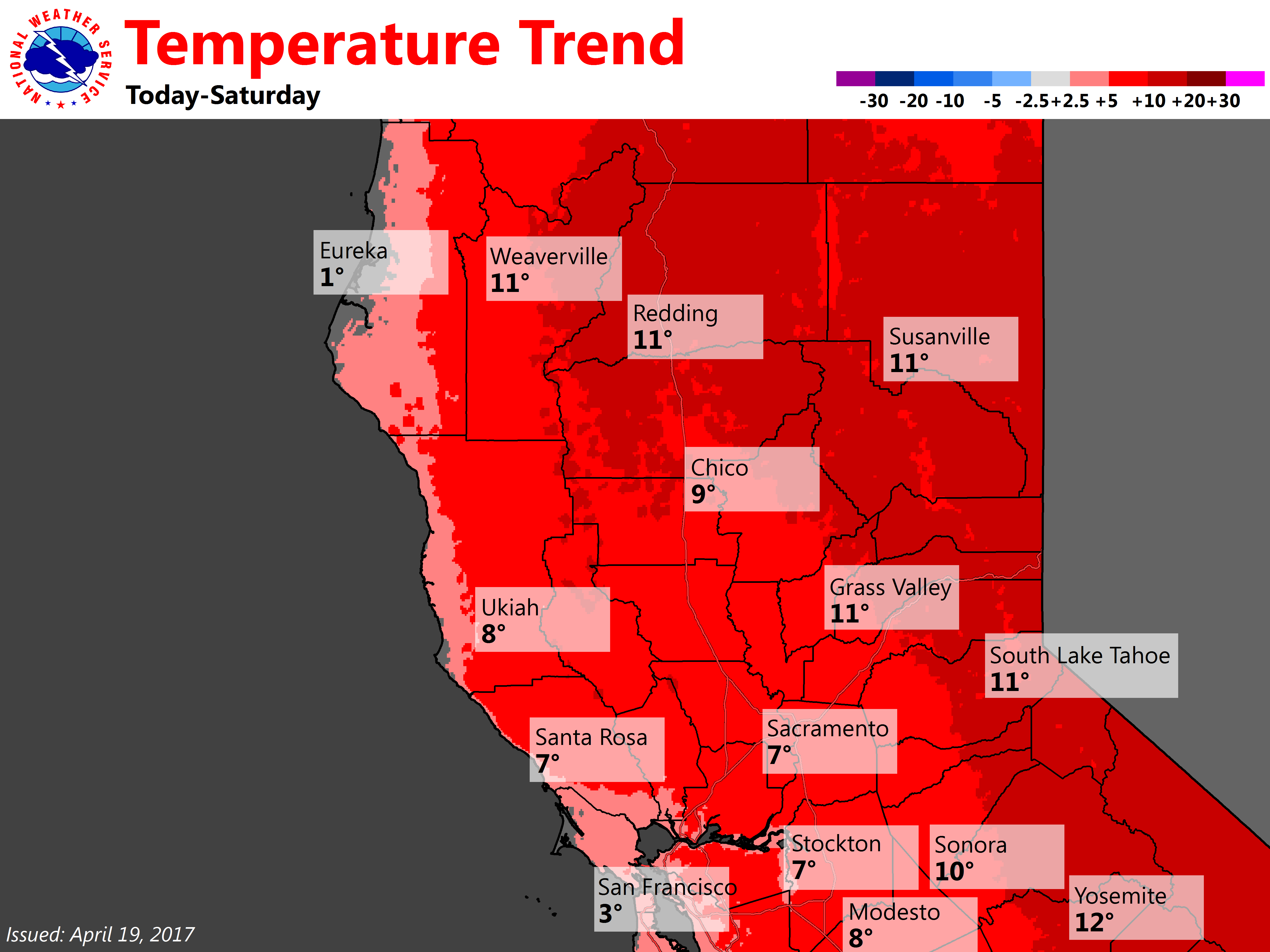
April 29, 2017 at 9:45 AM Beautiful and warm spring weekend – enjoy! A high pressure ridge over the west coast will bring fair skies and warmer than average temperatures through the weekend and beyond. The flow around this ridge will bring breezy north winds during the daytime hours.

April 29, 2017 at 9:41 AM Temperatures are heating up but area waterways are still running very cold & fast thanks to mountain snow melt. Use caution to avoid hypothermia! Even experienced swimmers can lose muscle control very quickly.
April 28, 2017 at 7:19 AM Windy today, dry and much warmer weekend. Increasing northerly winds today and continue through early this evening. The winds will peak in the afternoon in the Valley, strongest over the northern San Joaquin Valley, then diminish by early evening. Gusty winds continue across the west slope of the Sierra during the overnight and morning hours. Dry weather continues, with temperatures rising through the weekend into early next week.
April 27, 2017 at 8:16 AM Seasonally warm, breezy north winds and dry through next week. Weather systems will be deflected well to the north of the region over the next several days as ridging builds along the west coast. The result will be dry and milder weather for interior NorCal along with periods of breezy north winds for the Central Valley, especially Friday. Temperatures are expected to return to around average, or above, by the weekend.
April 26, 2017 at 9:45 PM The outage has been reduced to 1,168 customers in the Colfax to Eden Valley area along I-80. No cause yet, but crews are in the area restoring power to as many customers as possible. As always, treat any downed power lines as live lines and call 911 to report them.
April 26, 2017 at 9:42 PM No update from PG&E yet on a cause of the outage affecting 5,000+ customers in an area from Colfax to Brunswick Basin. All of Hwy 174 is affected. Estimated time of restoration is 11pm, subject to change.

April 26, 2017 at 8:42 PM PG&E now reporting 5,080 customers without power from Weimar via Colfax, Chicago Park to Brunswick Basin.
April 26, 2017 at 8:34 PM Multiple power outages affecting 2,000+ customers along Hwy 174 from Peardale to Colfax, PG&E has assigned a crew to assess the outage.
April 26, 2017 at 8:23 PM Power outage reported by a reader on Hwy 174 at Rollins Lake and Greenhorn Access Road.
April 26, 2017 at 5:45 PM Accident on Pleasant Valley Road at Blackledge Road in Penn Valley. CHP is on site. Thanks to reader Pam for the heads up
April 26, 2017 at 4:30 PM Truckee Police Advisory: Be advised that the water flow from Lake Tahoe into the Truckee River will be increased at 4:30 PM. Keep away from the edge of the river.
April 26, 2017 at 4:27 PM Non-injury traffic accident on Hwy 49 and Wolf Road next to the Bear River Market. Both cars are on the right-hand side.
April 26, 2017 at 7:48 AM A male white horse wandering the Lake Vera area is currently at Camp Augusta. If he is yours, please call Ronnie at 530-265-3702 and arrange for transport.
April 26, 2017 at 7:37 AM Light precip today, breezy north winds to bring warm up starting Thursday. A weak weather system will pass through Northern California today, bringing a few showers to the region. Warmer and drier weather is then expected starting Thursday and continuing into next week as the storm track shifts northward.
April 25, 2017 at 7:37 AM Scattered showers today and tomorrow, breezy and warmer later this week
April 24, 2017 at 8:46 AM The search for a missing plane continued over the weekend in Sierra County. At least 40 searchers, with mutual aid from Nevada County Search and Rescue, Marin County SAR, Tahoe Nordic SAR, Placer County SAR, El Dorado SAR, Monterey County SAR, Butte County SAR, Shasta County SAR, Contra Costa County SAR, San Mateo County SAR, Bay Area Mountain Rescue, CHP, Civil Air Patrol, California Office of Emergency Services, California Air National Guard, Salvation Army, and American Red Cross participated. No sighting has been reported yet.
April 24, 2017 at 7:26 AM Showers through Thursday. Several weather systems move through bringing cooler temperatures with some light precipitation through Wednesday.
April 22, 2017 at 9:26 AM Dry and warm today, weak systems bring cooler temps to start the week. Some clouds with cooler temperatures expected today. Slight chance of a shower possible over the northern mountains tonight into early Sunday. Series of storms will move through late Sunday into Thursday of next week bringing generally light precipitation to portions of Interior Northern California. Be aware! Temperatures are warming but rivers, lakes & streams are running very cold & fast due to mountain snow melt & reservoir releases!

April 21, 2017 at 12:53 PM Air Tankers are training for the 2017 fire season.
Just outside our office, over the South Yuba canyon, Tanker 96 practiced a water drop.
The Grass Valley Air Attack Base is slated to be fully staffed by June 15, or earlier if the situation warrants it.

Regular staffing includes two air tankers and one air attack (spotter) plane by Cal Fire.
In 2016, from June 13th to October 24th 255,107 gallons of retardant were pumped at the base. (10 year annual average=362,493 gallons – including the 2008 lightning event, the American Fire and the King Fire.)
The US Forest Service also has one air attack and one helicopter stationed at the airport, or White Cloud for the helicopter.

The GVAAB responds to fires in an area extending from Lake Oroville to the north to Plymouth in the south and everything east of I-5 and west to the Nevada stateline. In 2016, the largest fire in the base’s response area was the 5,646-acre Trailhead Fire. This fire started on June 28 and was fully contained on July 18, 2016.
The Emergency Command Center (ECC) is of course staffed 24/7 365 days a year.
April 21, 2017 at 12:26 PM Flood advisory due to increased waterflows starting this afternoon. Snowmelt and increased water release from Lake Tahoe.
April 21, 2017 at 9:32 AM Good advice from your Nevada County Fire agencies: We don’t want you to be the one whose debris pile escapes. Warmer conditions are expected for today, we remind you to burn responsibly!
April 21, 2017 at 7:25 AM Dry and warm weekend. High pressure will bring dry conditions and warmer weather to northern California today through this weekend. Temperatures will be near to slightly above normal. A stray shower is possible for the northern mountains Saturday night, but chances are small.
April 21, 2017 at 7:11 AM Per CAL FIRE/Fresno County Fire the Jayne Fire is 2,000+ acres and now 75% contained. The structure threat has been mitigated.
April 20, 2017 at 10:39 PM Large boulder in the roadway on Hwy 20 near Lake Spaulding Road. Eastbound lane towards the I-80 junction is blocked.
April 20, 2017 at 10:57 AM Non-injury accident on Hwy 49 near the Independence Trailhead. Two vehicles involved, accident is in the construction zone.
April 20, 2017 at 9:16 AM Two horses, one white and one brown, are running in the roadway on Jones Bar Road. Slow down and use caution! Thanks to reader Art for alerting us!
April 20, 2017 at 7:48 AM Showers begone, warmer weather moves in. Scattered showers will taper off this afternoon and sun will return to northern California. Seasonable weather is expected for Friday and the weekend.
April 19, 2017 at 10:40 PM Vehicle vs deer on northbound Hwy 49 at Combie Road. Vehicle on the right-hand side, deer is in the roadway. Use caution in the area.
April 19, 2017 at 8:53 AM Nevada County SAR, the Nordic Ski Patrol CHP and the Civil Air Patrol are searching for a downed plane that took off from the Tahoe-Truckee airport headed to Petaluma on Monday. The search has been going on since late Monday but had to be suspended
April 19, 2017 at 8:34 AM The latest from the NWS in Sacramento: A brief break in precipitation across northern California this morning with partly cloudy skies, then another weak storm brings light precipitation late this afternoon/evening into Thursday. Breezy winds anticipated this afternoon. Showers on Thursday are expected to diminish during the morning, then high pressure returns with dry and warmer weather Friday into the weekend. Although details are uncertain, another weather system could bring light precipitation to northern California for the beginning of next week.
April 19, 2017 at 7:49 AM Non-injury accident on Mount Olive Road and Lower Colfax Road. Both cars pulled over on the right-hand side, lanes are clear.
April 19, 2017 at 7:43 AM Chance of showers this afternoon into Thursday – then dry and warmer for the weekend. Another weather system will spread precipitation across NorCal this afternoon into early Thursday. Breezy southerly winds are forecast to pick up across interior NorCal this afternoon and tonight as another weather system moves into the region.
April 18, 2017 at 1:55 PM This stinks! 50-pound bags of manure have spilled onto the roadway on Brunswick Road at Burma Road in Grass Valley.
April 18, 2017 at 8:59 AM Roadway is now clear on Hwy49 at Carriage Road, traffic congestion is resorbing. Drive safe!
April 18, 2017 at 8:45 AM Scattered showers through Thursday, dry and warm weekend ahead. Decreasing threat of showers this evening with mostly dry weather expected overnight into Wednesday morning. Models spread leading edge of precip with next system across NW portions of the Interior NorCal by Wednesday afternoon. Mainly light precip spreads across most of the forecast area tomorrow night.
April 18, 2017 at 8:31 AM CHP has issued an alert, heavy congestion on Hwy 49 at Carriage Way. There is no estimated time of clearing, be prepared for long delays.
April 18, 2017 at 8:08 AM Multi-car accident on southbound Hwy 49 at Carriage Road. Traffic is backed up and moving very slowly. Emergency services are on scene.
April 17, 2017 at 2:39 PM Two car accident on Brunswick Drive on Hwy 174, roadway partially blocked. Emergency services on scene, no injuries reported.
April 17, 2017 at 12:12 PM Caltrans: Hwy 20 temporarily closed to right OT big rig at Hammonton/Smartville Rd and clean up spilled gravel. All lanes to open soon.
April 17, 2017 at 12:11 PM A vehicle is partially blocking the roadway, according to a report to CHP, on Mount Olive Road near Dog Bar Road in the Alta Sierra area. Use caution in the area.
April 17, 2017 at 11:49 AM Vehicle accident, unknown injuries, on the 14000 block of You Bet Rd in Grass Valley. Emergency services en route.
April 17, 2017 at 11:08 AM Hwy 20 near Smartsville is still closed due to the overturned big rig. Traffic is at a standstill. Thanks to a reader in the area for the update.
April 17, 2017 at 9:28 AM Hwy 174 is open in both directions now. Traffic is still backed up but should resolve shortly.

April 17, 2017 at 9:10 AM Thanks to Peardale/Chicago Park PIO Daniel Ramey for this update on the accident on Hwy 174: The roadway is being cleared now, reopening soon. Extrication using hydraulic jaws of life and spreaders was required for one patient, transported to Sutter Roseville.
April 17, 2017 at 8:52 AM Per CHP Grass Valley: SR-174 near the Bear River bridge is closed due to a multi-vehicle collision. There is no local detour in this area.

April 17, 2017 at 8:38 AM Overturned big rig on Hwy 20, one mile west of the Nevada/Yuba county line near Smartsville. Thanks to a reader for the heads up. Semi was carrying corn or rice, cleanup will take a while.
April 17, 2017 at 8:23 AM Accident on Hwy 174 at Odyssey Lane. Two cars involved, emergency services en route. Traffic is backed up on the Grass Valley side. Traffic from Colfax to Grass Valley is being held before the bridge.
April 17, 2017 at 7:13 AM Dreary, drizzly and damp through Thursday. Showers will continue across the region through Tuesday with a chance of thunderstorms Tuesday afternoon.
April 15, 2017 at 8:49 AM Dry and relatively warm today, then a series of storms through Thursday. If you are planning an Easter egg hunt on Sunday you may have to deal with some rain chances.
April 14, 2017 at 7:58 AM Drier weather Friday and Saturday, weak systems Sunday through Thursday. Today will be mostly dry with below normal temperatures. Saturday will be dry with near normal temperatures. Sunday a system moves in through the day spreading precipitation across the area. Light snow accumulations possible in the mountains. A series of systems will maintain the wet pattern through next Thursday, with periods of precipitation. Dry with above normal temperatures next Friday.

April 13, 2017 at 8:28 PM Thanks to reader Debbie for sharing this photo taken from a ridge overlooking the Bear River in the Dog Bar area.
April 13, 2017 at 3:59 PM The tornado warning for Yuba and Nevada counties has expired. Thunderstorms and heavy rains are still possible. A severe weather warning has been issued for a strong thunderstorm over Lake Of The Pines, or 9 miles north of Auburn, moving northeast at 35 mph. Half inch hail will be possible with this storm. Locations impacted include: Auburn, North Auburn, Foresthill, Cool, Newcastle, Applegate and Meadow Vista. Torrential rainfall is also occurring with this storm, and may lead to localized flooding. Do not drive your vehicle through flooded roadways.

April 13, 2017 at 2:56 PM Severe Thunderstorm Warning from 4/13/2017 2:51 PM to 3:15 PM PDT for Nevada County, Yuba County.
At 250 PM PDT, a severe thunderstorm was located over Beale AFB, or 10 miles east of Marysville, moving east.
Large hail and damaging lightning is occurring with this storm. Move indoors immediately.
April 13, 2017 at 12:17 PM Emergency services en route to an accident on eastbound Hwy 49 at McKnight Way in Grass Valley.

April 13, 2017 at 8:40 AM NWS Sacramento: RECORD BROKEN! Northern Sierra 8-station index now has wettest water year on record at 89.7″ surpassing old record of 1982-1983!
April 13, 2017 at 8:07 AM Thunderstorms today, drier on Friday and Saturday – precip returns Sunday afternoon. Hazardous mountain travel is possible today into the evening with chain controls, and delays at times. Thunderstorms are possible today, and some could be strong. Friday is expected to be mostly dry with below normal temperatures. Saturday will be dry with near normal temperatures. Sunday a system moves in through the day spreading precipitation across the area. Light snow accumulations possible in the mountains. A series of systems will maintain the wet pattern through next Thursday, with periods of precipitation.

April 12, 2017 at 5:16 PM NWS Sacramento: Strong thunderstorms are possible tomorrow throughout much of the area. Watch the skies & go indoors if thunder roars!
April 12, 2017 at 4:31 PM 75 customers without power in Alta Sierra on Maranatha P., Pekolee Dr. and Alice Way. Fire and PG&E crews are attempting to locate the cause of the outage.
April 12, 2017 at 7:50 AM Unsettled weather continues to dominate the skies above. Unsettled weather through late Thursday. Drier conditions Friday and Saturday. Another storm moves into the area on Easter Sunday and unsettled weather continues into early next week. Stay tuned for details.
April 11, 2017 at 11:07 AM Expect significant delays on Hwy 174 near You Bet Road. Tree removal operation is causing traffic to back up. Plan accordingly or use an alternate route.
April 11, 2017 at 8:22 AM Extended period of relatively cool, cloudy and wet weather. And the “march” (although we are in April) towards the wettest water year (wrt the 8 station index) continues. With less than one inch to go to break the 1982-83 record it seems that NorCal is destined to have a water year of historical proportions. But today’s system may not be wet enough to be the record breaker.
April 11, 2017 at 8:05 AM The top of a power pole has sheared off and lines are down on Slate Creek Road near Deer Park Drive in Grass Valley. Fire and emergency services en route.
April 10, 2017 at 3:03 PM Non-injury solo vehicle accident on McCourtney Road at Thoroughbred Loop.
April 10, 2017 at 11:36 AM Update from San Bernardino Chief Jarrod Burguan: Two adults are deceased in a classroom, believed to be a murder suicide. We believe the suspect is down and there’s no further threat. There are two wounded, possible students. Taken to local hospitals, condition unknown.
April 10, 2017 at 11:19 AM San Bernardino Police Chief via Twitter: There is a report of a shooting at Northpark Elementary. Large police response, please stay out of the area. We believe this to be a murder suicide. Happened in a class room. Two students have been transported to the hospital. Students at the school are be taking to Cajon high school for safety.
April 10, 2017 at 9:00 AM Heads up for a dog in the roadway on Perimeter Road near McCourtney.
April 10, 2017 at 8:40 AM The Library’s Bear River Station, located in Bear River High School, will be closed the week of April 10th for the school’s spring break. Public hours will resume on Monday, April 17th, at 4:00 p.m. All other branches of the Nevada County Community Library will be open as usual the week of April 10th.
April 10, 2017 at 8:07 AM Series of (mostly weaker) storms lining up for this week. A stormy week for interior NorCal as several storms line up over the Pacific Ocean and are expected to track toward the area.
April 8, 2017 at 3:13 PM Both lanes blocked on Purdon Road between Tyler Foote and the bridge at Purdon Crossing. Also, a large pine tree fell across River Ranch Road off Dog Bar Road. PG&E crews are on scene.
April 8, 2017 at 1:16 PM We have confirmed snow sightings at Wheeler Acres (thanks Shae), Meadow Vista (thanks Marcia) and Ridge Road in Nevada City (thank you Britta)

April 8, 2017 at 12:56 PM Snow in Foresthill at 2,500 ft elevation. Thank you Jeff Walloch for the photo!
April 8, 2017 at 12:29 PM Just got a report from reader Gina: Big fluffy snowflakes in Alta Sierra. Has anybody taken a picture?
April 8, 2017 at 10:31 AM Landslide reported on Marysville Road next to Bullards Bar Dam, just past the dam when traveling towards Moonshine Road and Camptonville. Use extreme caution n the area. Thanks to a reader for the info.
April 8, 2017 at 9:55 AM Unsettled, colder and more storms on the way. Unsettled weather pattern continues into next week. Scattered valley showers today with a few thunderstorms through the evening hours. Mountain snow will continue with chain controls and delays likely. Brief period of dry weather tonight – Sunday. A weaker system moves in for Sunday night into Monday, with showers mainly north of I-80. A third system is possible by the middle of next week with another round of widespread precipitation and breezy winds.

April 7, 2017 at 7:49 PM At 744 PM PDT, Doppler radar was tracking a strong thunderstorm over over Auburn, moving northeast at 35 mph.
Half inch hail and brief, but very heavy rains will be possible with this storm.
This strong storm was part of a line of thunderstorms that extended from Grass Valley to Roseville to Sacramento. The line will be nearly stationary while cells move to the northeast at nearly 30 mph through 830 pm.
Locations impacted include: Grass Valley, Lake Of The Pines, Colfax, Sugar Pine, Iowa Hill, Cool, Newcastle, Applegate, Weimar, Alta Sierra, Foresthill, Nevada City, Meadow Vista and Higgins Corner.
Very heavy rain may lead to localized flooding or ponding of water on roadways. Do not drive your vehicle through flooded roadways.
Frequent cloud to ground lightning is occurring with this storm. Lightning can strike 10 miles away from a thunderstorm. Seek a safe shelter inside a building or vehicle.
April 7, 2017 at 7:24 PM Roadways are flooding due to the torrential downpours. Use extreme caution, slow down or better yet, stay home.
April 7, 2017 at 6:28 PM At 620 PM PDT, Doppler radar was tracking a strong thunderstorm over Bangor, or 8 miles southeast of Palermo, moving northeast at 25 to 30 mph. Half inch hail, brief heavy rain and winds in excess of 30 mph will be possible with this storm. Doppler radar is indicating weak rotation with this storm. This storm has the potential to produce a funnel cloud. Other locations in the path of this storm include…Hurleton, Forbestown, Brownsville, and Challenge.
April 7, 2017 at 4:03 PM Power has been restored on Polaris Drive, Starbright Acres are should be restored by 4:30 pm today.
April 7, 2017 at 2:59 PM Traffic is backing up at the intersection of Hwy 20 and Penn Valley Drive due to defective traffic signals.

April 7, 2017 at 2:48 PM Torrential rain associated with a line of strong thunderstorms from Colfax to near Walnut Grove. Be aware of flooded roadways.
April 7, 2017 at 2:35 PM Chatting with local law enforcement yielded some good advice: “I have an uncontrolled urge to remind everyone that if the windshield wipers are going, the headlights should be on too! And when it’s raining folks should slow down, not tailgate and allow for longer stopping distances.” It would keep them inside their car a lot more and keep drivers a lot safer. Also, stop signs are not a suggestion and no, slowing doesn’t count. PS: Overshooting the stop line by 3/4 of a car length, because you see the police car at the last second and are going too fast as you approach the intersection to actually stop, doesn’t count as “Stopping” either…
April 7, 2017 at 1:47 PM Crews have arrived at the outage location, tree into power lines. Cascade Shores, Deer Creek Park, Hwy 20 and Blue Tent all out of power. Crews are starting repairs and rerouting power where possible.

April 7, 2017 at 1:16 PM 2,032 customers have lost power outside Nevada City. PG&E assessment crew is en route to the outage.
April 7, 2017 at 1:13 PM A large tree is blocking the northbound lane on Bitney Springs Road near Douglas Lane near Rough&Ready.

April 7, 2017 at 9:02 AM NWS Sacramento: Winter-like storm will bring moderate rain to the Valley, heavy snow for the mountains, and gusty winds. Valley thunderstorms are possible today and Saturday with some storms producing small hail and gusty winds. Dry weather returns Sunday before the wet pattern returns next week, with the most significant storm Wednesday or Thursday.
April 7, 2017 at 8:27 AM Great progress overnight by PG&E crews in reducing power outages in the area. By 4:00 pm, the 80 homes on Starbright Acres near McCourtney should be restored after the power lines are back up. Around 4:30pm, repairs are estimated to be completed for the remaining 146 homes out of power on Morning Star Lane, Slate Creek, Shannon Way, Greenwood Circle and Echo Ridge Drive. 10 customers on Gold Flat Road should have power restored by 3:30 PM. 137 customers in the Hwy 49 corridor between Cement Hill and Nishenam Gulch and 155 homes on Rock Creek and Rector Roads off Lake Vera/Purdon are still awaiting a restoration time.The same goes for the San Juan Ridge area, where 35 homes on Ivey Lane to Hyatt Way and 36 homes on Sages Road are waiting for restoration.
April 7, 2017 at 8:05 AM Brunt of storm continues through Saturday, winds lessen somewhat. Hazardous mountain travel is likely with chain controls, delays, accidents, and white-out conditions at times. Breezy southerly winds will continue today.
April 7, 2017 at 12:12 AM Roadway flooding on Hwy 174 at Law Ranch Cross Road. Reduce speed and use caution in the area.
April 7, 2017 at 12:03 AM New outages on Rattlesnake Road, Brewer Drive, Bitney Springs Road. Treat any down power lines as live lines, do not touch them, call 911.

April 6, 2017 at 11:41 PM Traffic is being held on I-80 east at Soda Springs. Chain controls are in effect between Kingvale and Donner Lake in both directions.
April 6, 2017 at 11:40 PM Both lanes on East Bennett in Grass Valley are blocked.
April 6, 2017 at 11:38 PM Tree down on Hwy 20 at Willow Valley Road. Already two accidents in the area reported. If you can avoid being on the road tonight, stay home.
April 6, 2017 at 11:30 PM McCourtney area and Starbright Acres now report a total of 411 homes without power in Grass Valley. Sages Road on the San Juan Ridge has 36 homes in the dark. 155 homes now out on Rector and Rock Creek Roads along Lake Vera/Purdon Road outside of Nevada City.
April 6, 2017 at 11:06 PM 45 homes on McCourtney, McCarter Way and W Van Tam Way outside of Grass Valley have lost power. Smaller outages on Starbright Acres and along Squirrel Creek Road.
April 6, 2017 at 10:54 PM New Outages on Rector, Rock Creek and North Bloomfield Roads outside of Nevada City.
April 6, 2017 at 10:45 PM New Mohawk, Glad Flat Road and Pinewoods in Nevada City are now out of power.
April 6, 2017 at 10:42 PM Power outage for 1,207 homes on Banner Lava Cap, Idaho-Maryland up to Red Dog Road outside of Nevada City. PG&E has assigned a crew to assess the outage.
April 6, 2017 at 10:29 PM Report of another outage on Banner Lava Cap near Idaho-Maryland Road outside of Grass Valley.
April 6, 2017 at 10:11 PM An additional 137 homes have lost power from Cement Hill/Hwy 49 down to Nishenam Gulch in the Nevada City area. PG&E has assigned a crew to assess the outage. 35 homes on Tyler Foote Crossing, Ivey Lane, Rose Hill Court and Hyayy Way on the San Juan Ridge without power. PG&E will be assessing the cause.

April 6, 2017 at 9:54 PM Power out for 505 homes in an area from Hwy 49, Newtown Road to Ridge Road in Nevada City. PG&E has assigned a crew to assess the outage.
Also, an oak tree fell on the power lanes on Jasper Lane off Allison Ranch Road south of Grass Valley, crews on scene. Thanks DS for the photo.
April 6, 2017 at 12:31 PM Vehicle vs tree at the intersection of Idaho-Maryland and Madrone Forest Drive in Grass Valley.

April 6, 2017 at 10:35 AM Traffic still flowing smoothly on I-80, wet roads only. Conditions will get progressively worse as the day goes on. Travel over the passes is not recommended on Friday and Saturday.
April 6, 2017 at 9:37 AM Nevada County Sheriff’s Office has released an update on the human remains found in Alta Sierra. Male victim died as a result of multiple gunshots to the head, autopsy reveals.
April 6, 2017 at 8:00 AM Strong gusty winds, heavy rain, heavy mountain snow and thunderstorms through Sunday. The next storm system impacts NorCal through early Sunday with the brunt of the storm expected on Friday and Saturday. Hazardous mountain travel is likely with chain controls, delays, accidents, and white-out conditions at times. Strongest winds are expected tonight and Friday with gusts over 50 mph possible in the Sacramento Valley leading to the potential for wind damage and power outages.

April 5, 2017 at 6:40 PM PCSO’s command post at Michigan Bluff Rd. concerning a male adult who shot at two law enforcement helicopters several times. Special resources are being utilized to try and safely resolve the situation. Michigan Bluff Rd. will be closed until further notice.
April 5, 2017 at 6:30 PM Law enforcement in the area of Michigan Bluff responding to an angry man shooting a gun in the direction of a law enforcement copter. Please avoid area, stay indoors. PCSO and other agencies on scene.
April 5, 2017 at 12:05 PM An abandoned black Ford pickup, no plates, was left in the roadway on Toby Trail, just off Greenhorn Road in Grass Valley.
April 5, 2017 at 11:09 AM Non-injury accident on Tyler Foote near Jackass Flats Road on the San Juan Ridge. Both vehicles are on the right-hand side.
April 5, 2017 at 9:29 AM Injured deer in the roadway on the 13600 block of Banner Lava Cap Road.
April 5, 2017 at 9:03 AM A silver Nissan has broken down on the Brunswick off ramp of eastbound Hwy 49. Use caution and reduce speed.
April 5, 2017 at 8:26 AM Beginning Wednesday, April 5, the US Forest Service will be conducting a 70 acre prescribed burn just north of Quincy near CA Hwy 70 by the Mt. Hough Ranger District Office. The burn will last 1-2 days depending on weather while the smoke may last a bit longer. The smoke is estimated to travel north/northeast and settle into valleys in the evening. Smoke could have a small impact on traffic in the Highway 70/Chandler Road area and perhaps some short duration impacts to Quincy. Firefighters will be monitoring road and smoke conditions throughout the burn.
April 5, 2017 at 8:07 AM Strong gusty winds, heavy rain, heavy mountain snow and thunderstorms starting late Thursday. The next system impacts NorCal Thursday through early Sunday with the brunt of the storm expected on Friday and Saturday. Hazardous mountain travel is likely with chain controls, delays, accidents, and white-out conditions at times. Strongest winds are expected Friday with gusts over 50 mph possible in the Sacramento Valley leading to the potential for wind damage and power outages.
April 4, 2017 at 8:04 PM Major injury accident, vehicle vs motorcycle, on Alta Sierra Road at Dog Bar Road. The roadway is now clear.
April 4, 2017 at 2:52 PM Empire IC reports a knockdown on the residential structure fire. Please avoid the area, numerous fire engines and equipment are in the area.
April 4, 2017 at 2:46 PM Nevada County Fire JOA units are on scene of a residential structure fire on East Empire Street in Grass Valley. Avoid the area, use Brunswick Basin as a detour.

April 4, 2017 at 12:13 PM NWS Sacramento: Hope you haven’t put away your warm clothes! Temperatures will drop 10-20 degrees between Wednesday & Friday in NorCal! #CAwx #CAstorm
April 4, 2017 at 12:09 PM Smoke from a 40-acre TNF control burn near Oregon Hill at Bullards Bar is visible in North San Juan, Penn Valley and Nevada City.
April 4, 2017 at 8:09 AM Partially cloudy today and tomorrow, still dry and warm. There is a significant change to a wet pattern late this week. Here’s an early projection of precipitation amounts through the weekend. The wettest system is expected Friday.

April 3, 2017 at 4:38 PM NWS Sacramento update: High pressure will bring warm and dry conditions for northern California through Wednesday. Breezy afternoon north winds today in the Valley. Wet weather returns starting Thursday, with precipitation spreading across the area and continuing through this coming weekend. Confidence continues to improve that a very wet storm system with gusty winds and heavy mountain snow will impact the region Friday into the weekend. Snow levels are uncertain at this point, but could drop to 4000 feet and possibly quite a bit lower Saturday night/Sunday as colder air pushes in. Moderate rain for the valley and foothills is expected, with possible thunderstorms.
April 3, 2017 at 9:28 AM A possibly abandoned vehicle is in the ditch on Newtown Road between Jones Bar and Empress Road. Lanes are clear.
April 3, 2017 at 9:08 AM Just to be perfectly clear, the two stories published on Saturday: NID ponders grand bargain on Centennial Dam and ERC to switch focus from VR to Cannabis were APRIL FOOLS stories, as the dateline indicated. Happy April Fools!
April 3, 2017 at 7:19 AM Breezy and warm today, brunt of storm arrives Friday. Breezy northerly winds today with dry weather continuing through mid-week. Precipitation chances return to the region beginning Thursday with the brunt of the next storm expected to affect the region on Friday. Showers continue over the weekend with lowering snow levels.
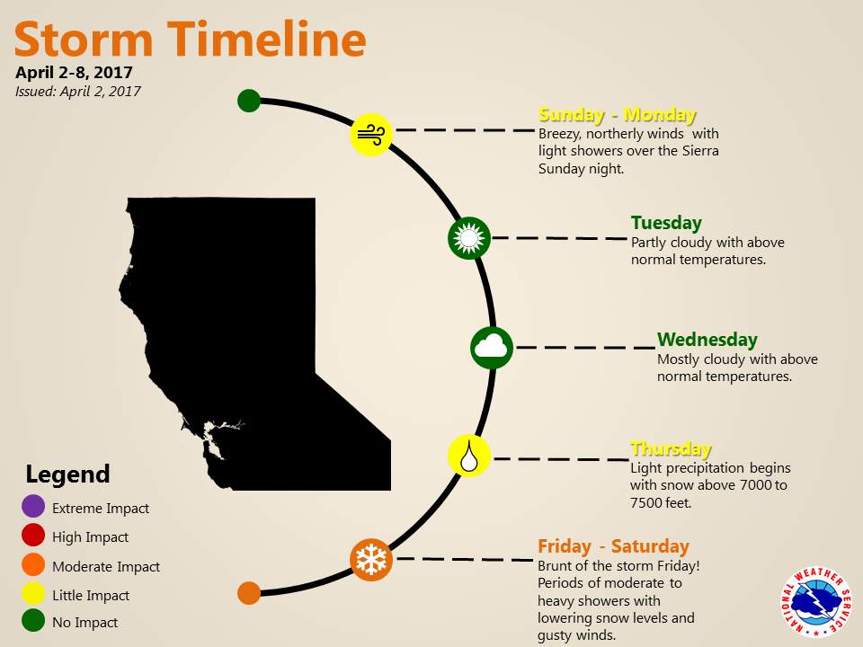
April 2, 2017 at 10:02 AM Dry and warm through Wednesday – atmospheric river makes landfall Thursday through Sunday. Here’s a look at the storm timeline for this week. Breezy winds Sunday and Monday with an Atmospheric River pattern impacting interior NorCal Thursday into the weekend with the brunt of the storm Friday into Saturday with occasionally heavy mountain snow.
April 1, 2017 at 10:10 AM 2,085 customers are without power in Auburn. PG&E assessment crew is en route to the outage, estimated time of restoration is noon today. 111 customers are also without power in the Red Dog/You Bet area outside of Grass Valley, PG&E is assessing the cause at the outage location and estimates restoration time to be 1:00 pm today.
April 1, 2017 at 9:22 AM Dry and warm continues this weekend. Generally dry weather is expected through Wednesday, except for some light Sierra showers Sunday night into early Monday. Breezy afternoon north winds are possible through Monday in the Valley. Unsettled weather is anticipated to return to northern California starting Thursday, with the potential for precipitation spreading into the area and continuing through next weekend. Confidence is improving that a wetter storm system could impact the region Friday into the weekend. Details are unclear at this point, stay tuned for updates!
April 1, 2017 at 9:00 AM If you are looking for last month’s log, you can find it here.
Power went out at 10:30 PM at Cedarsong Road and Hwy 49 on April 3rd.
Thank you Christy!
Power out at Echo Ridge near Nevada Union
Thank you Marni, stay safe.